
Craig Creek Trail
View Photos
Craig Creek Trail
Difficulty Rating:
Hike, bike, or horseback ride the Craig Creek Trail in the Pike National Forest. This picturesque, forested hike will lead adventurers through the verdant Colorado woodlands. If you are seeking a secluded hike among the highly trafficked Front Range hikes, the Craig Creek Trail is a great option. Perfect as a lengthy day-hike or an overnight excursion, this path is epic.
Getting there
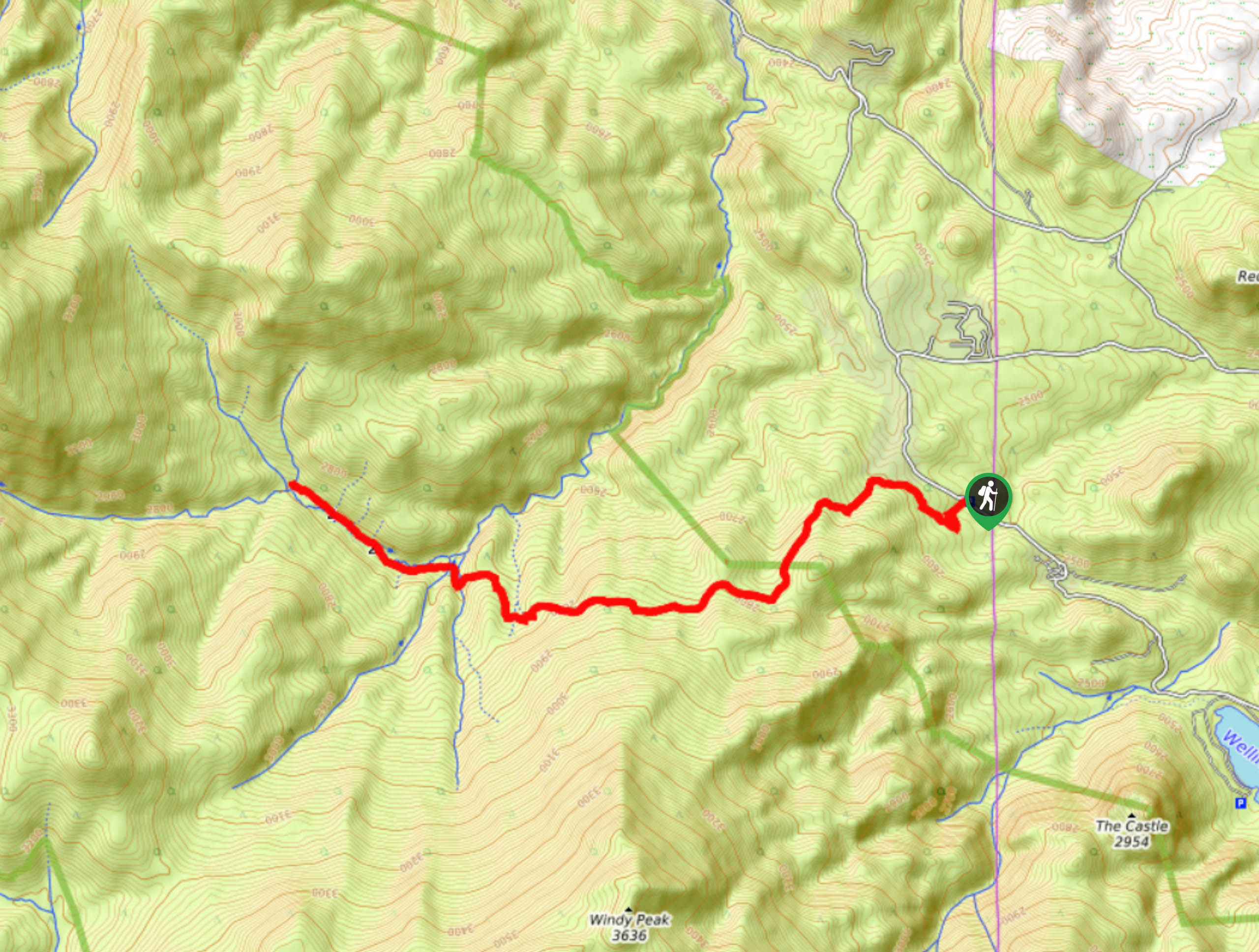
The Craig Creek Trail is off County Road 68.

About
| Backcountry Campground | Designated dispersed campsites along the trail |
| When to do | Year-round |
| Pets allowed | Yes - On Leash |
| Family friendly | Older Children only |
| Route Signage | Average |
| Crowd Levels | Moderate |
| Route Type | Out and back |
Craig Creek Trail
Elevation Graph
Weather
Craig Creek Hike Description
Disconnect from technology and the stressors of today’s world as you hike the Craig Creek Trail. What better way is there to relieve tension then to head out into the wilderness? Hike along the forest route and trek past historic mines and past dozens of babbling brooks. With the perfect ratio of elevation gain and technical terrain, this hike will get you moving without over exhausting you. Note this adventure is lengthy, so if you hope to conquer it in a day, head out in the early morning. We would also recommend bringing along the trail GPS to help you navigate the paths.
Embark on your excursion along the Craig Creek Trail from the trailhead and parking lot. From this point, you will want to track northwest on the Colorado Trail. The initial segment of this adventure has the steepest and most intense grade, but do not be discouraged. Summit the steep terrain and it will eventually plateau before guiding you down into a forested valley. Climb up the trail through the woodlands and notice some old mine remnants on the side of the path. Trek on through the forest and at the junction, veer right onto the Payne Creek Trail. Hike along the Craig Creek down the river valley as you pass several dispersed campsites.
You know you will have reached your turn around point when the valley trail begins to climb. Do not ascend the route unless you are prepared for a lengthy and strenuous backpacking excursion through the Lost Creek Wilderness. Instead, take a break, dip your tired feet in the creek and refuel before beginning your return. When you are ready, backtrack along the path all the way to the trailhead and car park.
Similar hikes to the Craig Creek Trail hike

Hankins Pass Hike
The Hankins Pass Hike is a quintessential adventure across the Lost Creek Wilderness. The hike demonstrates the diversity of the…

Miller Gulch Loop Trail
The Miller Gulch Loop Trail is a scenic meadowland adventure in the Pike National Forest. Hike through grassy meadows laden…

The Castle Hike
The Castle Hike is an exciting adventure up the steep, forested terrain to The Castle Rock. From atop the summit,…
Comments