
Storm Mountain Trail
View Photos
Storm Mountain Trail
Difficulty Rating:
Hike the Storm Mountain Trail up a forest road to the summit. The road to the peak is a bit steep, but as you stand on the summit and overlook the beautiful, forested landscape below and the Rocky Mountains that line the horizon, you will forget all about your tired feet. Shared with OTV vehicles and bikers in the summer, this path is a popular outdoor adventure.
Getting there
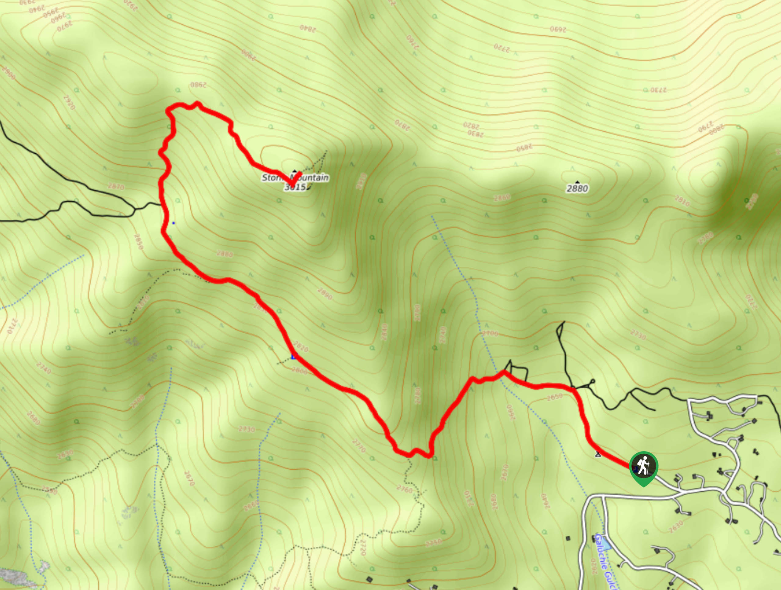
The Storm Mountain Hike is at the end of Pine Forest Way. Find parking just below the metal gate.

About
| Backcountry Campground | No |
| When to do | May-September |
| Pets allowed | Yes - On Leash |
| Family friendly | Older Children only |
| Route Signage | Average |
| Crowd Levels | Moderate |
| Route Type | Out and back |
Storm Mountain Trail
Elevation Graph
Weather
Storm Mountain Hike Description
Hike, bike or drive up to the summit of Storm Mountain. This wonderful wilderness excursion offers activities for all sorts of outdoor enthusiasts. The forest development trail, which is shared with OTV vehicles, is explicit and easy to follow. If you choose to drive up, be mindful of those hiking and biking along the road’s edge. Though the path travels through dense forests, the high altitude and sparse tree coverage at the summit warrants windy weather. Layers are always a good idea to protect against chilly winds. This route gradually ascends towards the peak, but it is worth noting that there are steep segments to navigate.
Begin your adventure up Storm Mountain Trail from the car park. Setting out from the parking area, track northwest up FDR 128. Hike up the meadowed trail and you will encounter an intersection. Here, stay left and merge onto Foggy Park Road. The trail will guide you over Galuchie Gulch and through tree shade. Continue hiking the road as it weaves you between tree shade and open meadows. Hike along the path as the elevation gains intensity. At the next junction, stay right on Foggy Park Road. At this point, the route will begin to curve as you begin ascending the Storm Mountain’s summit. Ascend the peak and you will be rewarded with views of the Rocky Mountain Range and the forested terrain below.
Enjoy the vistas that peek between the trees and notice an old mine in the north. Explore the Storm Peak’s summit and when you are ready, retrace your steps along the trail to the parking lot.
Similar hikes to the Storm Mountain Trail hike

Hankins Pass Hike
The Hankins Pass Hike is a quintessential adventure across the Lost Creek Wilderness. The hike demonstrates the diversity of the…

Miller Gulch Loop Trail
The Miller Gulch Loop Trail is a scenic meadowland adventure in the Pike National Forest. Hike through grassy meadows laden…

The Castle Hike
The Castle Hike is an exciting adventure up the steep, forested terrain to The Castle Rock. From atop the summit,…
Comments