Kelso Ridge Hike
View Photos
Kelso Ridge Hike
Difficulty Rating:
Hiking the Kelso Ridge Trail will guide you along a lollipop loop to not one, but up two summits in the Front Range. The path up to the summit of Torreys Peak and Grays Peak can be treacherous, but you will forget all about the exhausting journey when you summit a Colorado 14er and 13er.
Getting there
The Kelso Ridge Trail begins at the Grays Peak Trailhead at the end of the Stevens Gulch Road.

About
| Backcountry Campground | Dispersed Backcountry Camping, restrictions apply. |
| When to do | July-October |
| Pets allowed | Yes - On Leash |
| Family friendly | No |
| Route Signage | Average |
| Crowd Levels | High |
| Route Type | Lollipop |
Kelso Ridge Hike
Elevation Graph
Weather
Kelso Ridge Hike Description
We won’t lie to you, the Kelso Ridge Hike is challenging, but well worth the effort. The Kelso Ridge Trail will guide you through lush woodlands and up rocky ridges. Reserved for experienced hikers, this trail is not for the faint of heart. Hiking up to such high altitudes, expect cold and inclement weather. Check the forecast prior to setting out, wear layers and pack microspikes to help you navigate icy conditions at the summit. Bring plenty of water and know your limits, many have to turn around before completing this demanding journey. Note that though the trail is dog-friendly, it is not recommended due to the technical and rocky terrain.
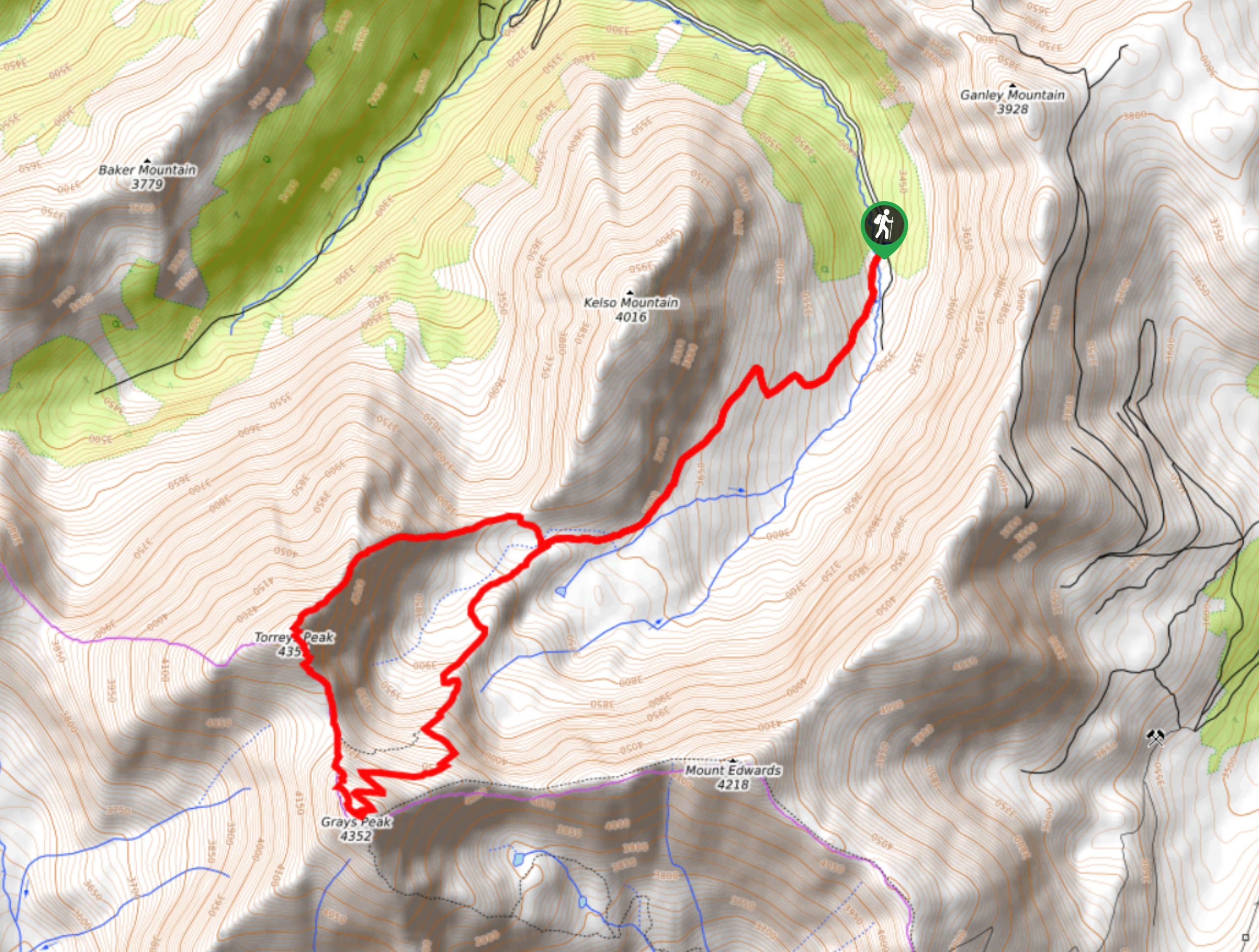
Departing from the parking lot, take the Grays Peak trail along Quayle Creek. Hike through the forested valley and the trail will eventually diverge away from the creek and up the border of Kelso Mountain. Climb up the switchbacks and tree coverage will become sparser. Climb up the trail and you will meet a fork in the road. The path can be completed in either way, but we recommend going counterclockwise. From the junction, take Kelso Ridge northwest, and hike up the steep terrain along the rocky ridge. Track along the ridge and scramble up the loose rocky scree to the summit of Torreys Peak. Enjoy the views from the summit of a Colorado 14er.
Hike down the south side of the summit and descend into the saddle. Trek along the windy ridge and up to Grays Peak. Navigate the switchbacks up the steep terrain. Revel in the vistas from atop the Continental Divide. Take a break and hike down the northeast side of the mountain. Notice the Eagles Nest Mine as you descend the Grays Peak Trail. Soon you will meet the junction at the end of the loop. Retrace your steps along the Grays Peak Trail all the way back down to the parking lot.
Similar hikes to the Kelso Ridge Hike hike

Hankins Pass Hike
The Hankins Pass Hike is a quintessential adventure across the Lost Creek Wilderness. The hike demonstrates the diversity of the…

Miller Gulch Loop Trail
The Miller Gulch Loop Trail is a scenic meadowland adventure in the Pike National Forest. Hike through grassy meadows laden…

The Castle Hike
The Castle Hike is an exciting adventure up the steep, forested terrain to The Castle Rock. From atop the summit,…
Comments