
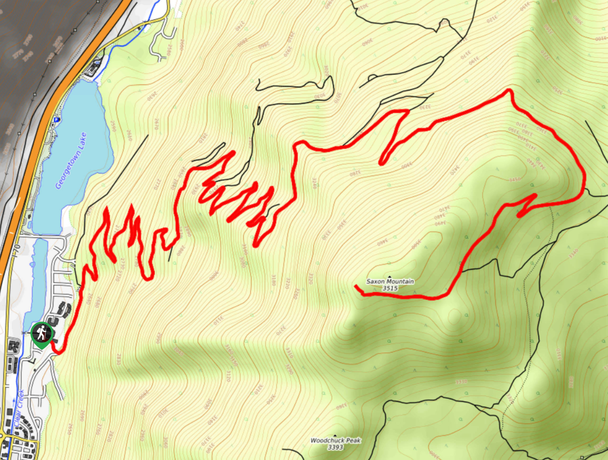
Saxon Mountain Hike
View Photos
Saxon Mountain Hike
Difficulty Rating:
Share the summit trail with mountain bikers and off-roading vehicles. The Saxon Mountain Hike is an exciting adventure up a winding dirt road to a stunning overlook at the summit. This trek is demanding, but the scenery along the path will motivate you to keep hiking.
Getting there
The Saxon Mountain Trailhead is off 19th Street in Georgetown, Colorado.

About
| Backcountry Campground | No |
| When to do | June-October |
| Pets allowed | Yes - On Leash |
| Family friendly | No |
| Route Signage | Poor |
| Crowd Levels | Moderate |
| Route Type | Out and back |
Saxon Mountain Hike
Elevation Graph
Weather
Saxon Mountain Hike Description
We love the Saxon Mountain Trail because the adventure possibilities are endless. Hike it, run it, bike it or drive it; this route offers activities that all sorts of outdoor enthusiasts will enjoy. If you choose to bike or hike this route, just note that it is lengthy and steep, so pack plenty of water and snacks to refuel. As you hike up the path, be cautious of speedy drivers and do your best to stay on the shoulder of the road for your own safety. As you travel up the path you will also notice several old log cabins that line the trail. From trailhead to summit, this hike is scenic.
Embark on your adventure up the Saxon Mountain Trail from the Georgetown Visitors Center. From the centre, travel up the well-marked Saxon Mountain Road. Hike up the route as it guides you into the woodlands. Hike through the mixed forest and notice the historic log structures that litter the path. Soon you will encounter the tightly wound switchbacks. Navigate the steep winding terrain and notice sights of Georgetown below. Hike up the seemingly never-ending switchbacks and once completed, revel in the sight of what you just completed. Take a breath before continuing up the trail. As you near the summit of Saxon Mountain, you will encounter a confusing junction—stay to the far right on the Saxon Mountain Trail.
Once you summit Saxon Mountain you will find several picnic tables overlooking the expansive vistas. Take a moment to appreciate what you completed as you look down on the hill and see the tiring switchbacks below. See sights of Georgetown in the west and Mount Evans Peak in the south. Revel in the scenery and recharge before beginning your descent. When you are ready, retrace your steps back down the trail to the Visitors Centre.
Similar hikes to the Saxon Mountain Hike hike

Hankins Pass Hike
The Hankins Pass Hike is a quintessential adventure across the Lost Creek Wilderness. The hike demonstrates the diversity of the…

Miller Gulch Loop Trail
The Miller Gulch Loop Trail is a scenic meadowland adventure in the Pike National Forest. Hike through grassy meadows laden…

The Castle Hike
The Castle Hike is an exciting adventure up the steep, forested terrain to The Castle Rock. From atop the summit,…
Comments