Ruby Gulch Trail
View Photos
Ruby Gulch Trail
Difficulty Rating:
Escape the city and head out into the Colorado wilderness. The Ruby Gulch Trail is an unforgettable hike in the Arapaho National Forest. Hike through the forested valley and intersect with several alpine creeks. If you enjoy woodland hikes, then you have found your match.
Getting there
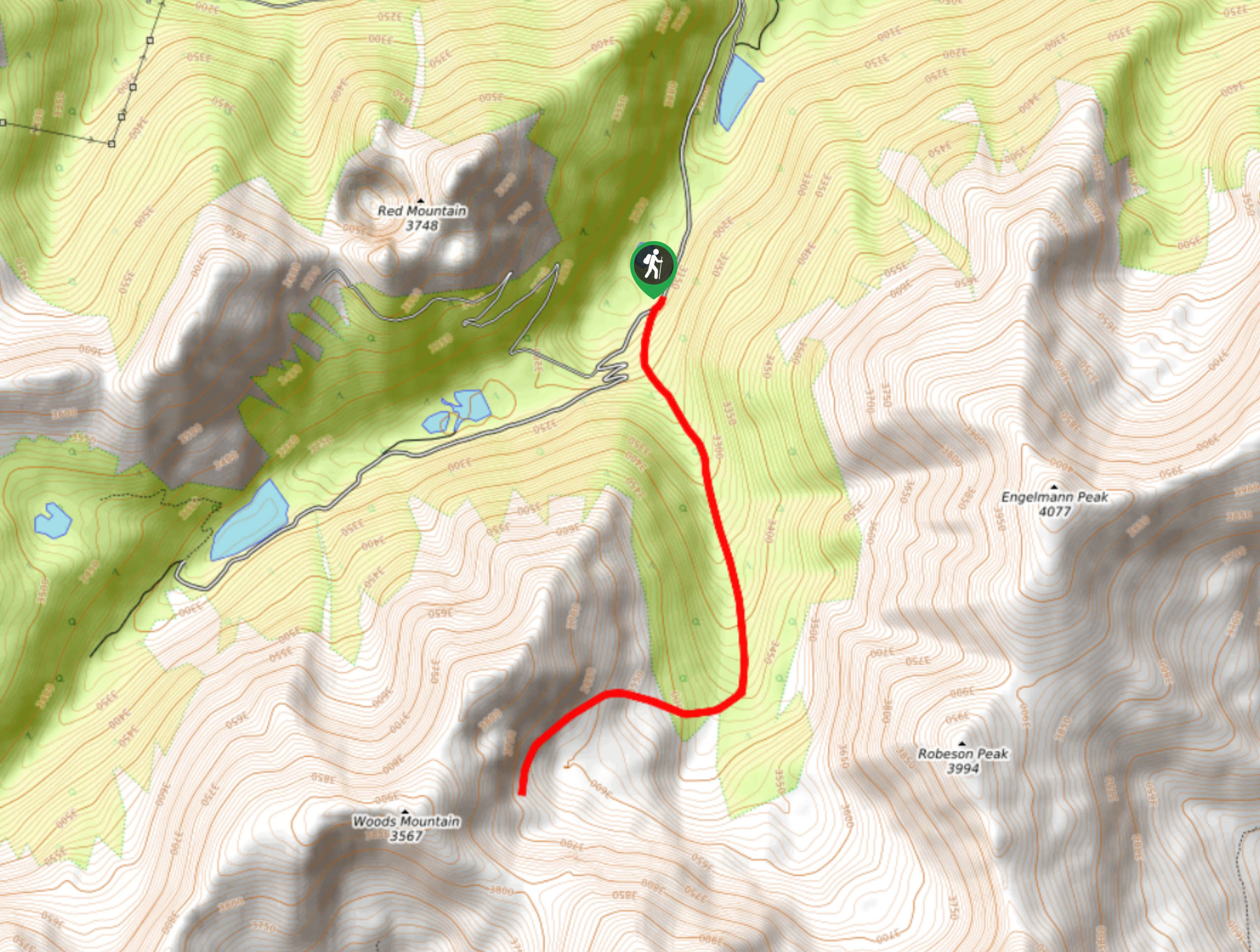
The Ruby Gulch Trail is located off Woods Creek Road.

About
| Backcountry Campground | Dispersed Backcountry Camping, restrictions apply. |
| When to do | Year-round |
| Pets allowed | Yes - On Leash |
| Family friendly | Older Children only |
| Route Signage | Poor |
| Crowd Levels | Low |
| Route Type | Out and back |
Ruby Gulch Trail
Elevation Graph
Weather
Ruby Gulch Hike Description
The Ruby Gulch Hike is a leg burner. Hike up the steep rocky terrain to a scenic overlook. Enjoy vistas of the snow-dusted peaks that line the horizon and the alpine tundra below. Get your workout in as you travel up the steep, rocky terrain. Make sure you are wearing shoes with good traction to help you navigate the slick rocks as you cross the streams. Don’t worry, the streams are shallow and there are plenty of rocks to help you cross the water without getting your feet wet. Note there are sections of this path that are difficult to navigate, we recommend bringing along the trail GPS to help you stay on track.
Begin your adventure from the Ruby Gulch Trailhead. Take the Ruby Gulch Trail southwardlyl. Trek up the rocky gulch along the babbling streams. Enjoy the secluded ambiance of the trail and the towering pine trees. Continue up the gulch, carefully navigating the several stream crossings. As you travel south, the primitive route will become increasingly challenging to follow. Use the trail GPS to help you maneuver the unmarked path. Follow the rocky path, and you will eventually be guided southwest up a rocky ridge. Ascend the ridge and you will be rewarded with striking views.
Revel in the expansive mountainous views, rest and refuel before commencing your return to the car. To get back to the trailhead, retrace your steps down the valley trail.
Similar hikes to the Ruby Gulch Trail hike

Hankins Pass Hike
The Hankins Pass Hike is a quintessential adventure across the Lost Creek Wilderness. The hike demonstrates the diversity of the…

Miller Gulch Loop Trail
The Miller Gulch Loop Trail is a scenic meadowland adventure in the Pike National Forest. Hike through grassy meadows laden…

The Castle Hike
The Castle Hike is an exciting adventure up the steep, forested terrain to The Castle Rock. From atop the summit,…
Comments