
Watrous Gulch Trail
View Photos
Watrous Gulch Trail
Difficulty Rating:
The Watrous Gulch trail is a demanding adventure through the Arapaho National Forest. With the perfect balance between strenuous and scenic, this is perfect for adventurous spirits seeking a challenge. Get a workout in as you ascend the steep rocky terrain to a stunning overlook.
Getting there
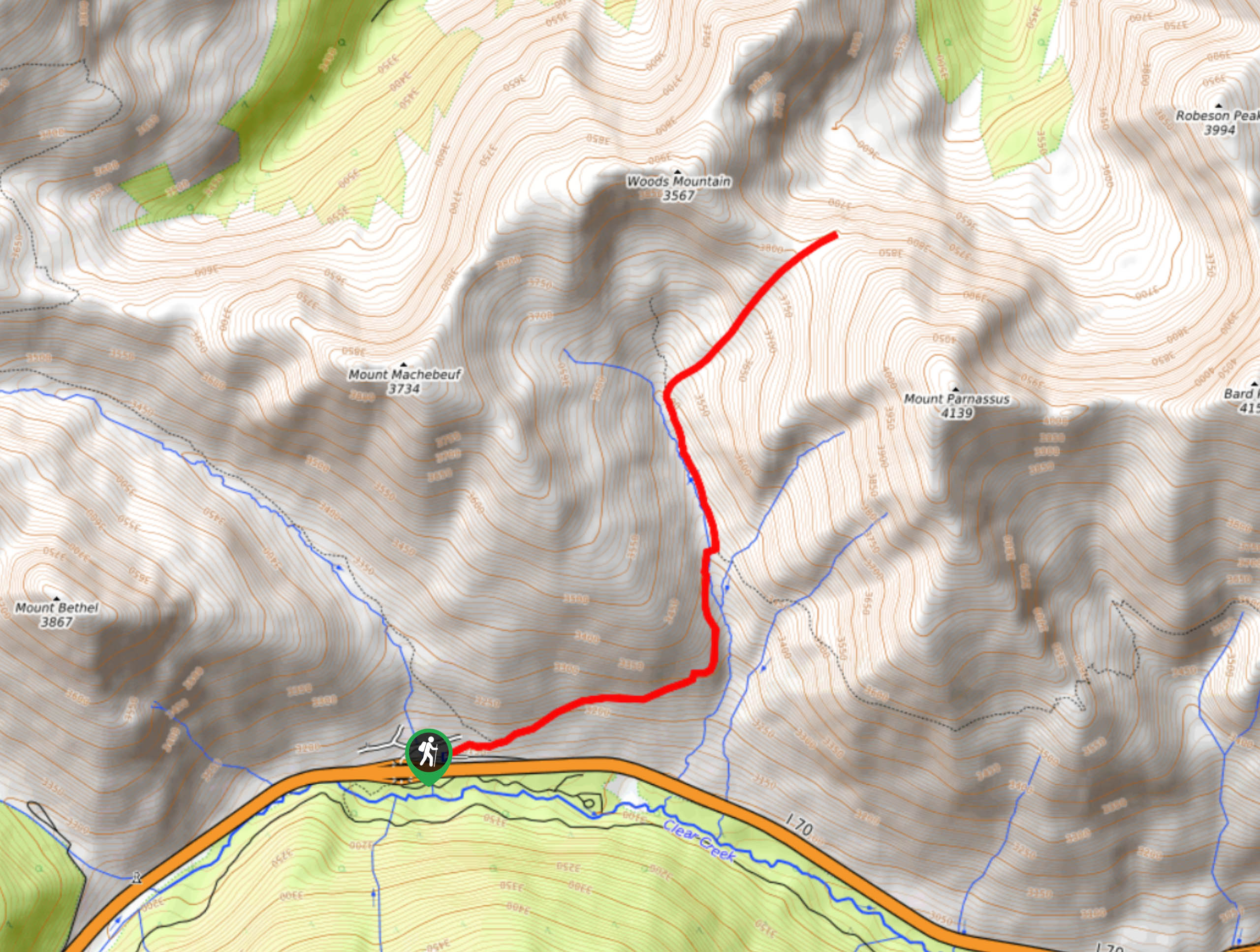
The Watrous Gulch Hike is located at the Herman Gulch Trailhead off I-70.

About
| Backcountry Campground | Dispersed Backcountry Camping, restrictions apply. |
| When to do | June-October |
| Pets allowed | Yes - On Leash |
| Family friendly | Older Children only |
| Route Signage | Average |
| Crowd Levels | High |
| Route Type | Out and back |
Watrous Gulch Trail
Elevation Graph
Weather
Watrous Gulch Hike Description
The Watrous Gulch Trail is not for the faint of heart. Travel up the steep and technical terrain to the pass overlooking the encompassing snow-capped mountains. This scenic hike is a popular nature trail in the Front Range wilderness. We would recommend arriving early to secure a spot in the small parking lot. Note this path is exposed; ensure to wear sunscreen in the summer months and wear layers to protect against windy conditions as you gain altitude.
Begin your journey up the Watrous Gulch Trail from the Herman Gulch Trailhead. Track northwest along the Herman Gulch Trail and stay right at the first intersection. Here, you will be diverted onto the Watrous Gulch Trail. Hike through the meadowlands before climbing under sparse alpine tree coverage. Continue trekking up the path as it follows the curves of the Watrous Gulch Creek. The path will become almost entirely exposed as you near the mountain cirque. See Mount Machebeuf in the west, Woods Mountain in the north and Mount Parnassus in the east.
Continue travelling up the route as it guides you northeast up to the pass. You will enjoy 360-degree views of the snow-dusted peaks and the forested landscape below from the mountain saddle. If you are feeling adventurous, hike up the summit of Mount Parnassus or Woods Mountain. Revel in the vista before retracing your steps along the path back to the trailhead.
Similar hikes to the Watrous Gulch Trail hike

Hankins Pass Hike
The Hankins Pass Hike is a quintessential adventure across the Lost Creek Wilderness. The hike demonstrates the diversity of the…

Miller Gulch Loop Trail
The Miller Gulch Loop Trail is a scenic meadowland adventure in the Pike National Forest. Hike through grassy meadows laden…

The Castle Hike
The Castle Hike is an exciting adventure up the steep, forested terrain to The Castle Rock. From atop the summit,…
Comments