
Palisade Mountain Hike
View Photos
Palisade Mountain Hike
Difficulty Rating:
Hike the Palisade Mountain Trail to an epic overlook of the surrounding mountainous landscape and Continental Divide. Guaranteed you will break a sweat on this short, but steep hike up the granite summit of Palisade Mountain. Make sure to sign the logbook to let people know you conquered the climb!
Getting there
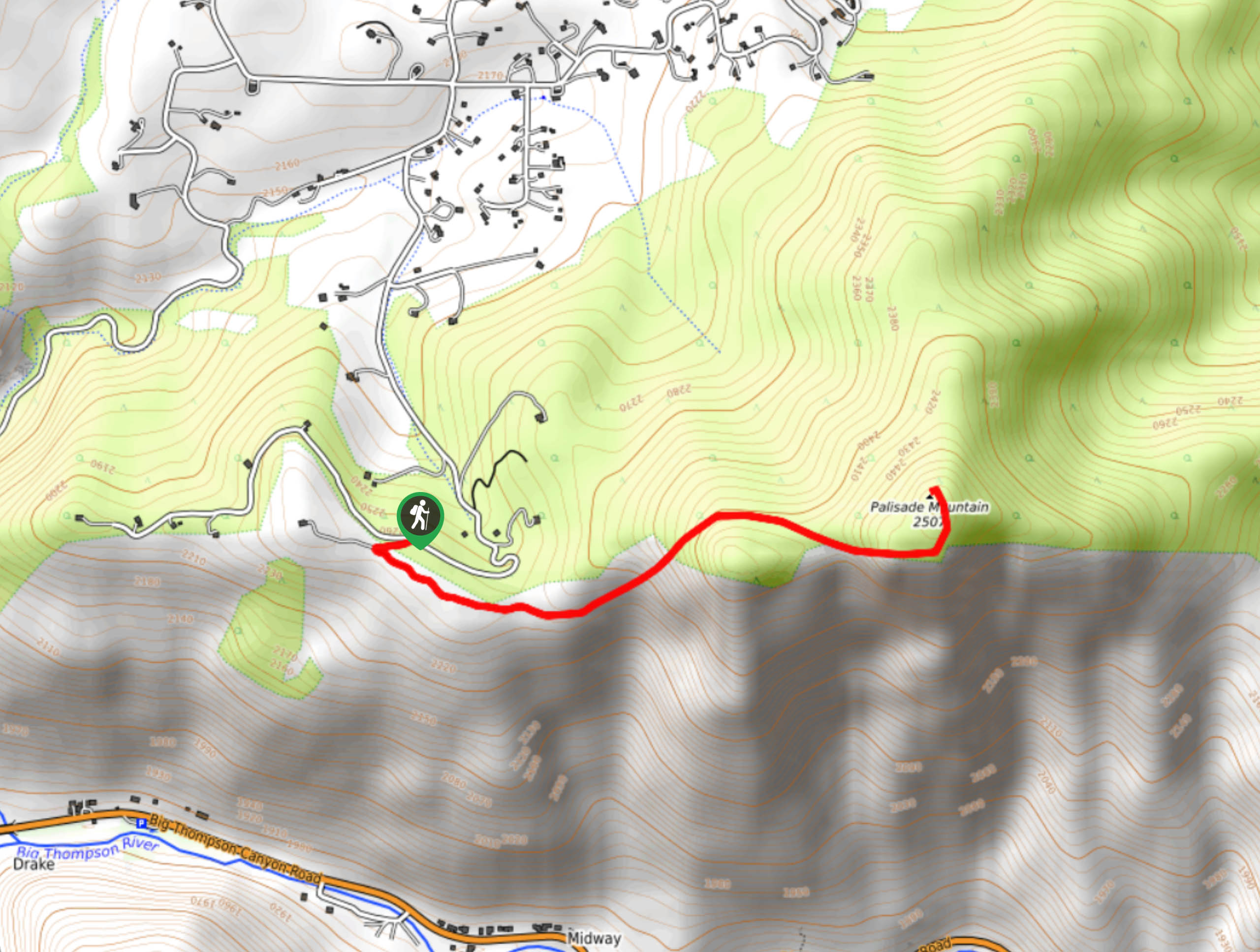
The Palisade Mountain Hike Trailhead is located off Snow Top Drive near Drake, Colorado.

About
| Backcountry Campground | No |
| When to do | April-November |
| Pets allowed | Yes - On Leash |
| Family friendly | Older Children only |
| Route Signage | Poor |
| Crowd Levels | Low |
| Route Type | Out and back |
Palisade Mountain Hike
Elevation Graph
Weather
Palisade Mountain Hike Description
Short but sweet, the Palisade Mountain Trail is one of our favorites. Hike up the isolated trail and enjoy expansive views of the mountainous horizon and the forested valleys below. If you are seeking a challenge that won’t take up the whole day, consider the Palisade Mountain Hike. This steep trail is fairly primitive, marked only by rock cairns at the summit. We suggest having the trail GPS handy in case you find yourself off course. Additionally, you will have to do some scrambling up to the summit. Ensure you are prepared to climb and note that even older children may have difficulty navigating the rocky cliff. The steep climb and high altitude will tire you, so make sure to pack plenty of water to refuel!
When you are ready to roll, depart from Palisade Mountain Trailhead and Parking Lot. The trail begins at the forest service gate off the car park. Hike along the Powerline Road through a grassy meadow while keeping your eyes peeled for grazing deer. Track up the path through the grasslands and the trail will eventually guide you beneath tree coverage. Hike amongst the towering trees and enjoy the increasingly scenic views peeping through the foliage. Ascend the woodland path and it will become more primitive and harder to follow. At this point you will want to closely follow the cairns up to the summit. The route will become rockier as you climb, and you will have to navigate two granite canyons.
Climb up the canyons and scramble up the boulder cliff to the summit. From the peak of Palisade Mountain you will enjoy panoramic vistas of the Continental Divide and its mesmerizing ridges. The mountain top is rocky so mind your footing to avoid rolling an ankle. Explore the summit and revel in the breathtaking views of the Continental Divide before beginning your descent. To get back to the trailhead, simply retrace your steps down the trail.
Similar hikes to the Palisade Mountain Hike hike

Hankins Pass Hike
The Hankins Pass Hike is a quintessential adventure across the Lost Creek Wilderness. The hike demonstrates the diversity of the…

Miller Gulch Loop Trail
The Miller Gulch Loop Trail is a scenic meadowland adventure in the Pike National Forest. Hike through grassy meadows laden…

The Castle Hike
The Castle Hike is an exciting adventure up the steep, forested terrain to The Castle Rock. From atop the summit,…
Comments