
Mount Parnassus Hike
View Photos
Mount Parnassus Hike
Difficulty Rating:
Mount Parnassus Hike is a demanding adventure, but it is well worth the effort. Reserved for experienced hikers, this primitive trail guides outdoor enthusiasts through the lush Colorado woodlands and up rocky ridges to the summit of Mount Parnassus. Featuring expansive mountain views and stunning forested scenery, this trail is a must-add to the Colorado adventure list.
Getting there
Find the Mount Parnassus Trail at the Herman Gulch Trailhead off the I-70.

About
| Backcountry Campground | Dispersed Backcountry Camping, restrictions apply. |
| When to do | June-October |
| Pets allowed | No |
| Family friendly | No |
| Route Signage | Poor |
| Crowd Levels | Low |
| Route Type | Lollipop |
Mount Parnassus Hike
Elevation Graph
Weather
Mount Parnassus Hike Description
Craving a challenge? Hike the Parnassus Trail up the technical terrain to the summit of a Colorado 13er. The Mount Parnassus Trail is an experienced hiker’s dream. Climb through the forestlands before navigating rocky talus fields to the peak. This primitive trail is not always explicitly marked, so we recommend having the trail GPS handy to help navigate the overgrown terrain. Pack plenty of water and ensure you are acclimated to high altitudes before attempting this hike. Wear layers and check the weather prior to departing on your adventure to avoid inclement weather at the summit. This hike is not for the faint of heart, so make sure you are prepared to do some scrambling and are ok to hike up steep, demanding terrain.
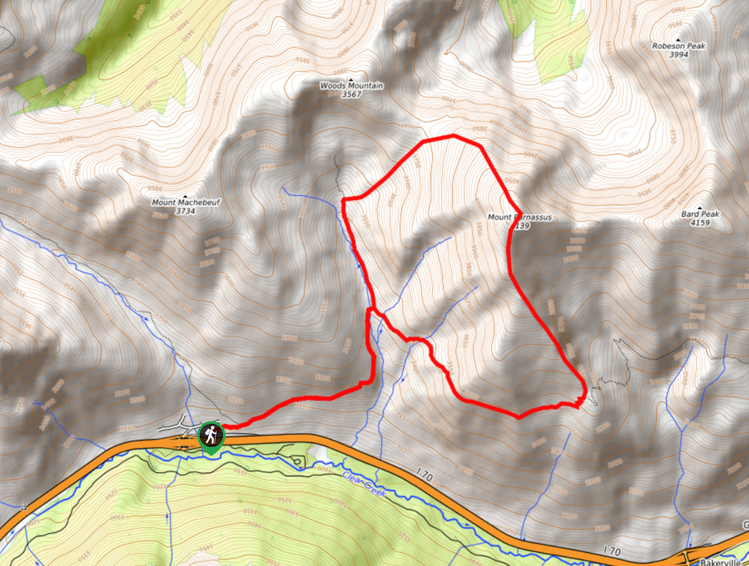
Embark on your adventure up the Mount Parnassus Trail from the Herman Gulch Trailhead. From the trailhead, track along the Herman Gulch Trail until you encounter a junction. At the intersection, stay right and you will be diverted onto the Watrous Gulch Trail. Hike up the forested gulch along the Watrous Creek until you eventually meet a fork in the road. At this point, you can choose the direction by which to complete this loop, but we recommend going counterclockwise. Veer right and take the Bard Creek Trail. You will intersect with the creek several times as you climb the path. Track southwestward along the route and you will confront another intersection. Here, take a left onto the Mount Parnassus Trail.
Scramble up the ridge’s steep rocky scree to Mount Parnassus’ summit. At the peak take a breather and enjoy the expansive vistas of the Front Range. Notice Bard peak over the ridge in the east and Woods Mountain and Mount Machebeuf in the northwest. Revel in the views before descending the rocky scree. Mind your footing as you follow the primitive route down to Watrous Gulch. Use the trail GPS to help navigate the unmarked path. Hook back onto the Watrous Gulch Trail and then at the junction, retrace your steps down gulch to the Herman Gulch Trail and back to the parking lot.
Similar hikes to the Mount Parnassus Hike hike

Hankins Pass Hike
The Hankins Pass Hike is a quintessential adventure across the Lost Creek Wilderness. The hike demonstrates the diversity of the…

Miller Gulch Loop Trail
The Miller Gulch Loop Trail is a scenic meadowland adventure in the Pike National Forest. Hike through grassy meadows laden…

The Castle Hike
The Castle Hike is an exciting adventure up the steep, forested terrain to The Castle Rock. From atop the summit,…
Comments