
Lower Dadd Gulch Trail
View Photos
Lower Dadd Gulch Trail
Difficulty Rating:
Hidden amongst the Front Range wilderness, the Lower Dadd Gulch Trail is a scenic and secluded adventure for outdoor enthusiasts. With a gradual grade and easy-to-navigate terrain, this hike is optimal for those looking for a relaxing walk or families with older children.
Getting there
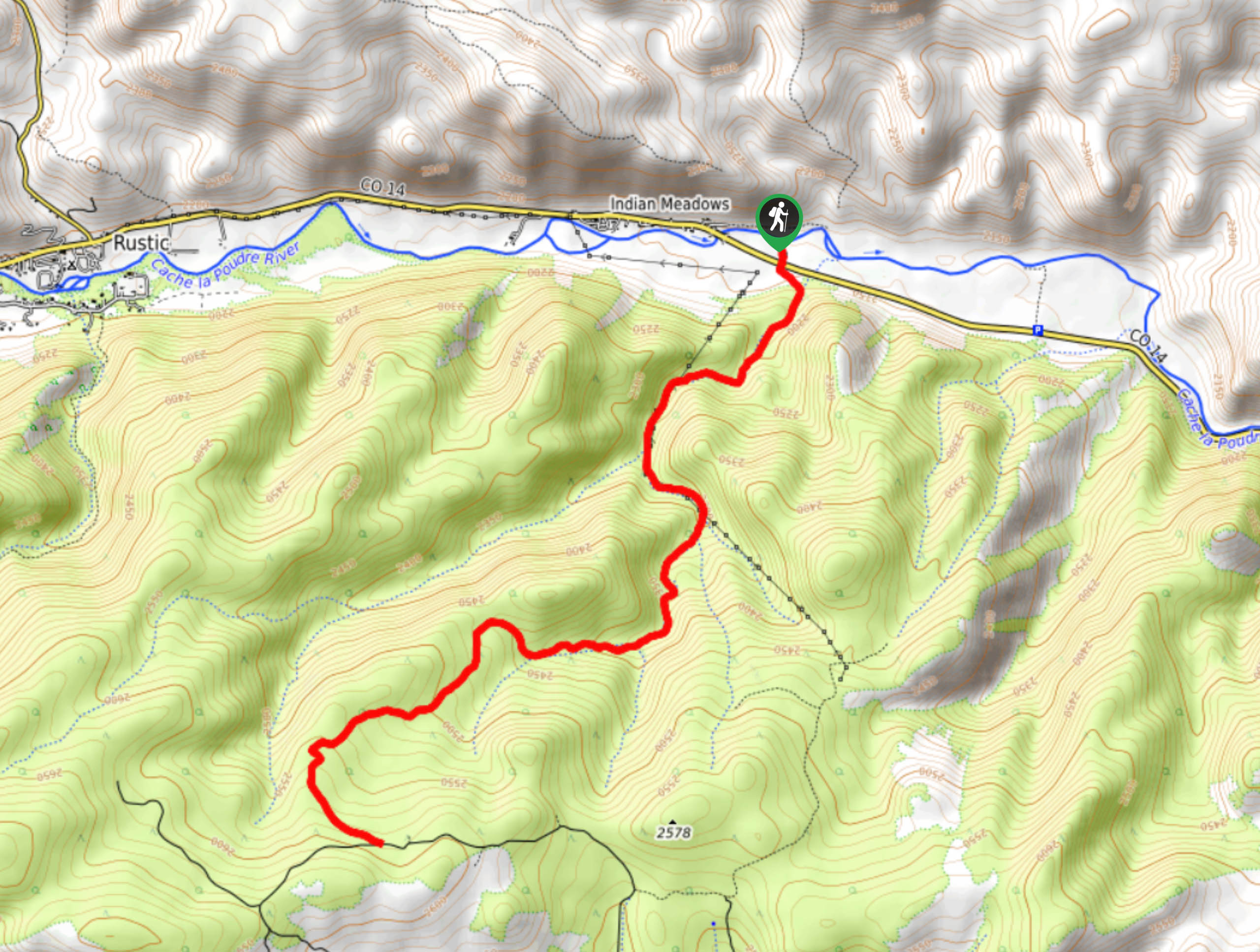
The Lower Dadd Gulch Trail is located off the Poudre Canyon Highway near Glen Echo, Colorado.

About
| Backcountry Campground | Dispersed Backcountry Camping, restrictions apply. |
| When to do | April-November |
| Pets allowed | Yes - On Leash |
| Family friendly | Older Children only |
| Route Signage | Average |
| Crowd Levels | Moderate |
| Route Type | Out and back |
Lower Dadd Gulch Trail
Elevation Graph
Weather
Lower Dadd Gulch Hike Description
Easy to navigate and well-marked, the Lower Dadd Gulch Trail is perfect for hikers of almost all skill levels. Leave the hustle and bustle of the city behind and head out into nature. Travel through lush Colorado meadows, through a mixed ponderosa pine and aspen forest, and up along an exposed path with scenic overlooks. Shared with mountain bikers and horse riders, be respectful of those also using the trail.
Cross the Poudre Canyon Highway to the trailhead from the parking lot. From the trailhead, the Lower Dadd Gulch Trail follows an old stock trail up along the creek. Hike along the meadowed trail as you gradually ascend into the forestlands. Hike the dirt path under the coverage of ponderosa pines and vibrant aspens. Trek along the trail and enjoy the meditative sounds of the babbling creek that lines the path. As you climb up the route and past the burn, you will eventually ascend the timberline and the path will open to panoramic vistas of the surrounding Front Range mountains.
Soon you will meet the Salt Cabin Park Road, this is your turnaround point. Revel in the expansive scenery before retracing your steps back to the trailhead and over the highway to the car park.
Similar hikes to the Lower Dadd Gulch Trail hike

Hankins Pass Hike
The Hankins Pass Hike is a quintessential adventure across the Lost Creek Wilderness. The hike demonstrates the diversity of the…

Miller Gulch Loop Trail
The Miller Gulch Loop Trail is a scenic meadowland adventure in the Pike National Forest. Hike through grassy meadows laden…

The Castle Hike
The Castle Hike is an exciting adventure up the steep, forested terrain to The Castle Rock. From atop the summit,…
Comments