
Lizard Rock Hike
View Photos
Lizard Rock Hike
Difficulty Rating:
The Lizard Rock Hike is a scenic adventure that borders the Lost Creek Wilderness. Hike this one-way trail through aspen groves interspersed with towering spruce, past alpine creeks and up to the Lizard Rock and overlook. Keep an eye out for wildlife as you trek this impressive wilderness excursion.
Getting there
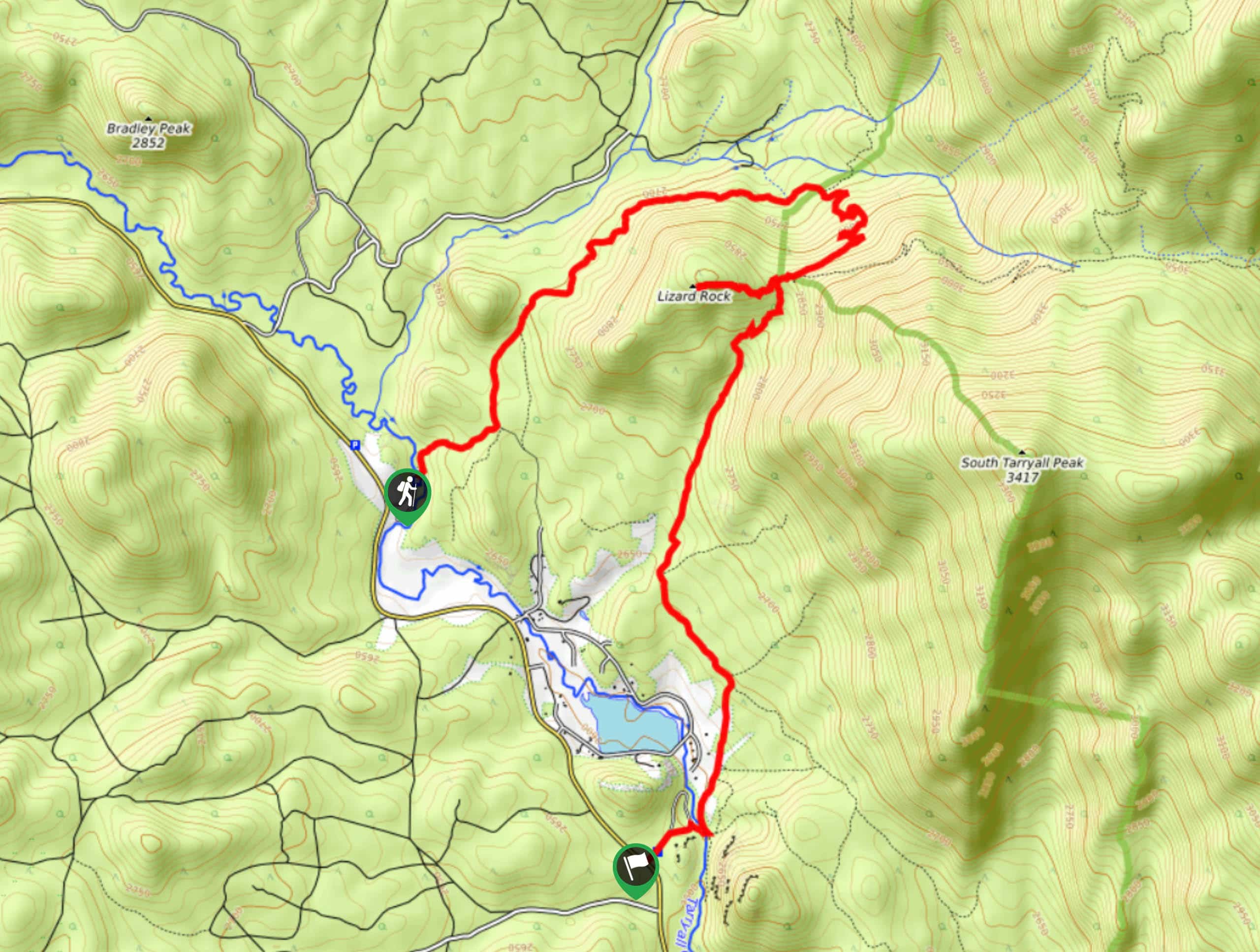
The Lizard Rock Hike departs from the Brookside McCurdy Trailhead and ends at the Spruce Grove Campground.

About
| Backcountry Campground | Dispersed Backcountry Camping Permitted, restrictions apply. |
| When to do | April-October |
| Pets allowed | Yes - On Leash |
| Family friendly | Older Children only |
| Route Signage | Average |
| Crowd Levels | Low |
| Route Type | One Way |
Lizard Rock Hike
Elevation Graph
Weather
Lizard Rock Hike Description
Embark on your adventure up to Lizard Rock from the Tarryall Creek Valley and ascend the picturesque nature trail up to the geological wonder that is the Lizard Rock. This unique trail is one-way, meaning you will be rewarded with new scenery every step of the way! What could be better? Just make sure to arrange pickup or leave a car at the Spruce Grove Campground prior to beginning your adventure, because the last thing you will want to do after a tiring hike is deal with transportation. This trail is considerably shorter than most point-to-point expeditions, but it does climb in altitude. Pack plenty of water, wear layers, and check the forecast to avoid getting caught in an afternoon storm at the summit. Additionally, self-issuing permits are mandatory for hikers. Pick these free permits up at the trailhead and keep them with you for the entirety of your journey.
Begin your Lizard Rock Hike from the Brookside McCurdy Trail. Cross the Tarryall Creek and the path will guide you beneath the timberline. Hike up the forested path, noticing the vibrant aspens and spruce trees towering above. Ignore intersecting and merging routes until you meet the Hankins Pass Trail. Veer right onto the Hankins Pass Trail and you will be guided up several sets of tightly wound switchbacks. Navigate the winding terrain up to the Lizard Rock Trail. Keep right and trek this route out to Lizard Rock.
Explore Lizard Rock and discover how the granite sculpture got its name. Take a break, meander around the lizard shaped boulders and enjoy the stunning overlook of the mountainous wilderness. When you are ready, retrace your steps along the trail back to the intersection. Here, you will want to veer right down another branch of the Lizard Rock Trail. Keep along this path until it delivers you to the Spruce Grove Campground. Be wary of rattlesnakes and barbed wire along this route. When you make it down to the campground you have met your adventure’s end.
Similar hikes to the Lizard Rock Hike hike

Hankins Pass Hike
The Hankins Pass Hike is a quintessential adventure across the Lost Creek Wilderness. The hike demonstrates the diversity of the…

Miller Gulch Loop Trail
The Miller Gulch Loop Trail is a scenic meadowland adventure in the Pike National Forest. Hike through grassy meadows laden…

The Castle Hike
The Castle Hike is an exciting adventure up the steep, forested terrain to The Castle Rock. From atop the summit,…
Comments