
Little Beaver Creek Trail
View Photos
Little Beaver Creek Trail
Difficulty Rating:
Leave the city in the rear-view mirror and head out into the Comanche Peak Wilderness. Immerse yourself in nature as you travel along the Little Beaver Creek Trail. This stunning adventure is a great path to clear your head and reconnect with yourself and the outdoors. Hike through the woodlands, through plains, and over river crossings.
Getting there
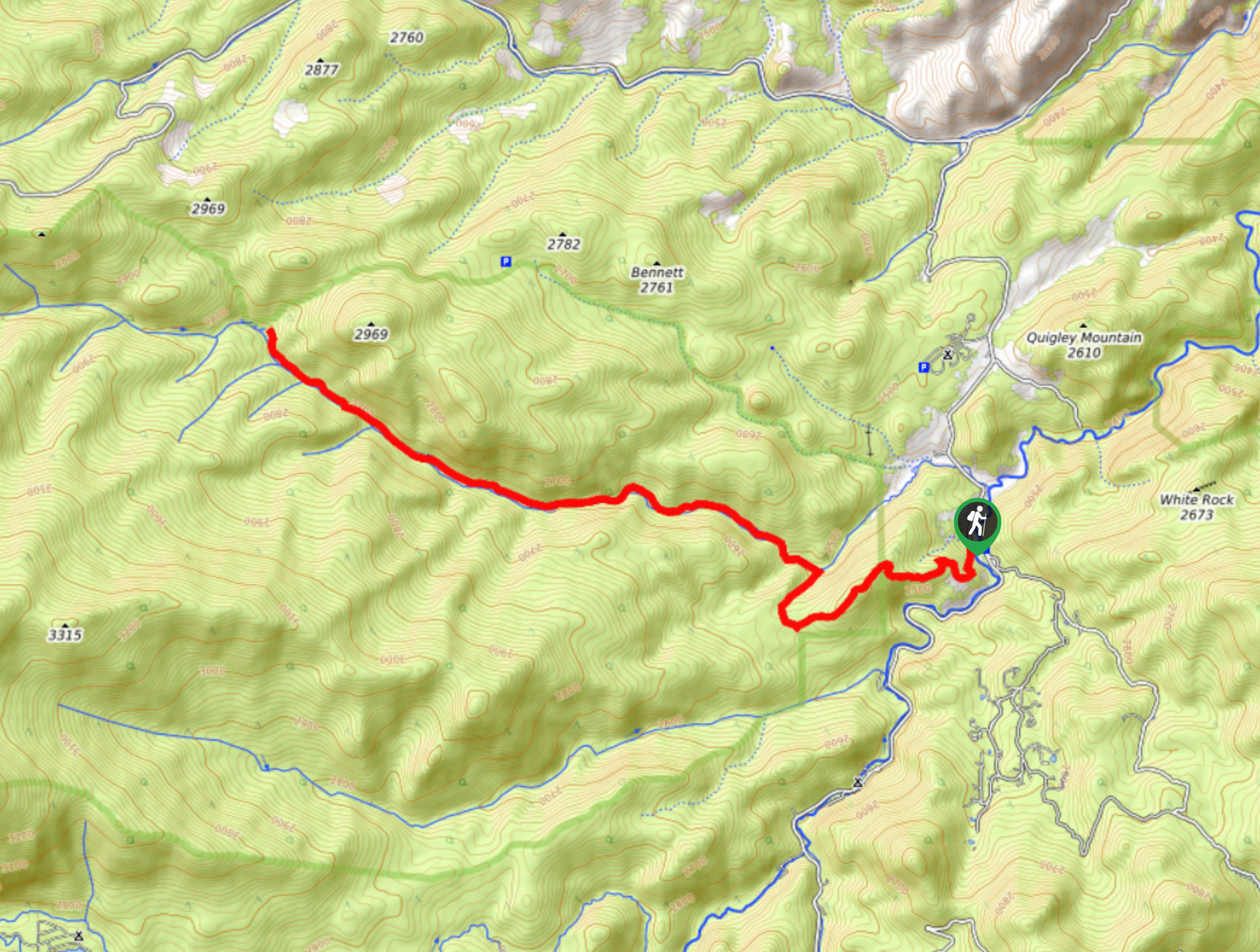
Little Beaver Creek Hike is accessed via the Fish Creek Trailhead off N County Road 63E.

About
| Backcountry Campground | Dispersed Backcountry Camping, restrictions apply. |
| When to do | March-November |
| Pets allowed | Yes - On Leash |
| Family friendly | Older Children only |
| Route Signage | Average |
| Crowd Levels | Moderate |
| Route Type | Out and back |
Little Beaver Creek Trail
Elevation Graph
Weather
Little Beaver Creek Hike Description
The Little Beaver Creek Trail is a meditative nature excursion through the Colorado wilderness. Hike along the diverse trail and disconnect yourself from technology and stressors as you navigate the path through the verdant forest land along a babbling creek. With the perfect amount of elevation gain, you will feel satisfied but not overtired after completing this lengthy hike. Make sure to bring plenty of water or a water filter to keep yourself and your four-legged friend hydrated along the trail. Enjoy all that nature has to offer along the Little Beaver Creek Trail.
From the parking lot, take the Fish Creek Trail and head southwest. This path will guide you in and out of tree coverage. Shortly after you depart from the trailhead, you will meet a junction, veer right here. Shortly after turning, you will confront another intersection. At this point, you will want to turn left onto Little Beaver Creek Trail. Hike along Little Beaver Creek through the woodlands. Following the curves of the creek, ignore any merging trails. Eventually, you will meet Beaver Pond; this is a great spot to rest and re-energize. When you are ready, hook back on the trail as it climbs northwest. Soon you will encounter an intersection.
The junction with Flowers Trail is your turnaround point. If you wish to continue up the Little Beaver Creek Trail or turn onto the Flowers Trail, you can. Bear in mind these are lengthy extensions to your trip, so ensure you have enough gas left in the tank for your return. When you are set to head back, simply retrace your steps along the Little Beaver Creek Trail down to Fish Creek Trail and back to the car park.
Similar hikes to the Little Beaver Creek Trail hike

Hankins Pass Hike
The Hankins Pass Hike is a quintessential adventure across the Lost Creek Wilderness. The hike demonstrates the diversity of the…

Miller Gulch Loop Trail
The Miller Gulch Loop Trail is a scenic meadowland adventure in the Pike National Forest. Hike through grassy meadows laden…

The Castle Hike
The Castle Hike is an exciting adventure up the steep, forested terrain to The Castle Rock. From atop the summit,…
Comments