
Jones Pass Hike
View Photos
Jones Pass Hike
Difficulty Rating:
The Jones Pass Trail is a popular route in the Arapaho National Forest. This adventure can be completed in several different ways. Drive the Jones Pass Trail, hike it, bike it, run it or snowshoe it. Whether you come in the peak of summer or in the dead of winter, we can almost guarantee that you will encounter many adventurers on this path!
Getting there
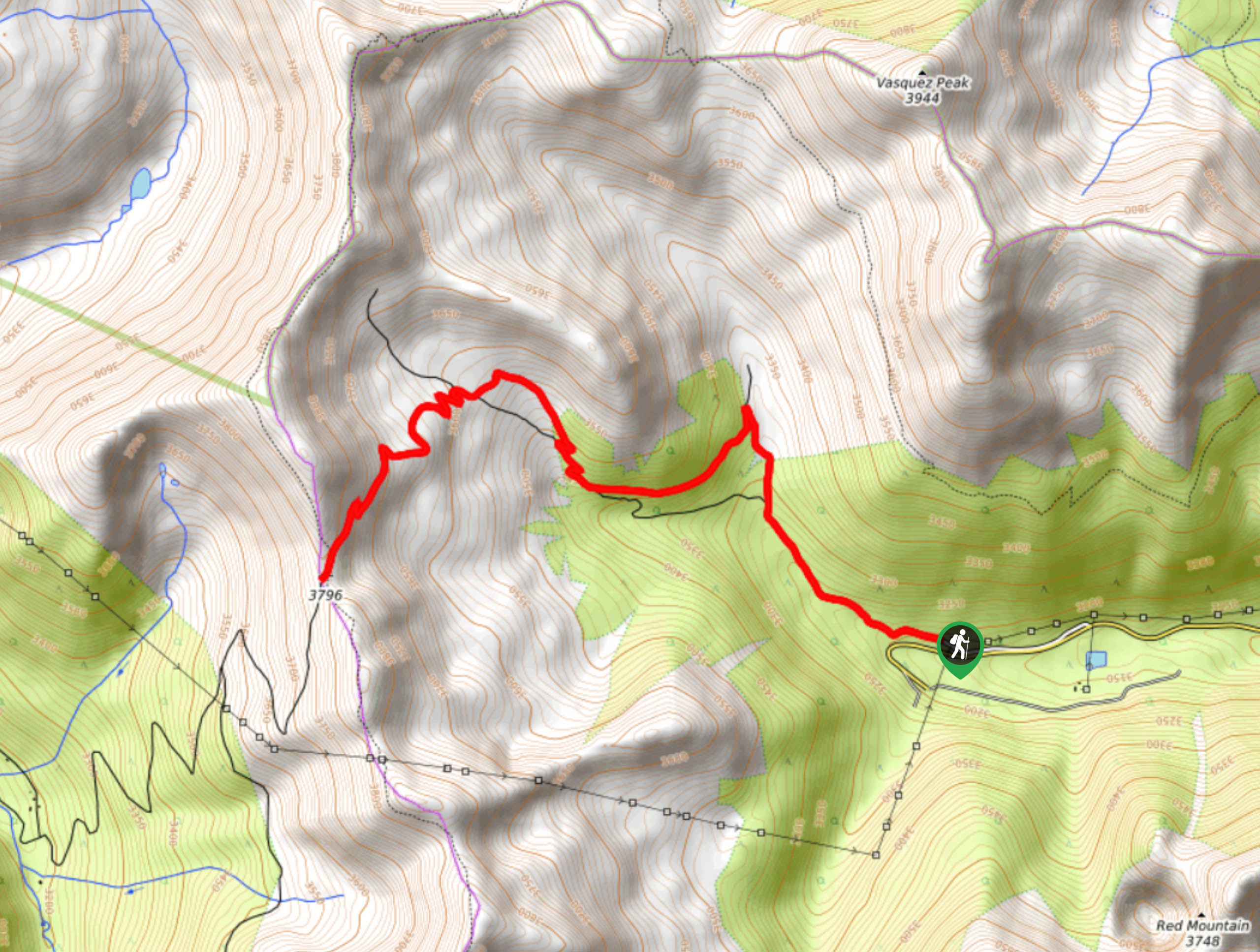
The Jones Pass Trailhead is located off the I-70.

About
| Backcountry Campground | Yes, Dispersed Campsites along Jones Pass Road |
| When to do | Year-Round |
| Pets allowed | Yes - On Leash |
| Family friendly | Yes |
| Route Signage | Average |
| Crowd Levels | High |
| Route Type | Out and back |
Jones Pass Hike
Elevation Graph
Weather
Jones Pass Hike Description
The Jones Pass Hike is awesome because it can be enjoyed year-round. Our favorite season to hike up the pass is fall, so we can admire the beauty of the vibrant foliage. The season you choose to adventure the Jones Pass is up to your description, just note that it will be extremely windy on the Continental Divide, no matter what season it is. If you choose to drive the gravel road up the pass, make sure you have a 4×4 vehicle and high ground clearance. Please also be mindful of those hiking or biking along the route.
Depart from the Jones Pass Trailhead off of the I-70. If you are walking the Divide, simply park your car here. Hike the trail northwest up the pass. Follow the gravel road and be mindful of passing vehicles. Track along the trail and the climb will become increasingly intense. If you aren’t used to the high elevation, make sure to stop for breaks and keep hydrated. Continue along the path and you will notice dispersed campsites on the edge of the trail. The ones near the trailhead are semi-shielded from the wind by the towering pines. Soon, you will encounter an intersection; stay right on the gravel trail.
Shortly after the junction you will meet another fork in the road, here stay left on the gravel route. Navigate a few switchbacks and you will ascend the treeline. Again, you will confront off-shooting trails, maintain along the rocky road. Track along the windy ridgeline as the path curves you southwest. The campsites along the exposed ridgeline have striking views of the Rocky Mountains, but the wind is extreme. Eventually, you will confront an extremely steep section of the trail. Scale the route and you will summit Jones Pass.
Enjoy the expansive mountainous views and sights of the lush woodlands below. Appreciate the grandeur of the scenery from atop the Continental Divide before retracing your steps all the way back down to the parking lot.
Similar hikes to the Jones Pass Hike hike

Hankins Pass Hike
The Hankins Pass Hike is a quintessential adventure across the Lost Creek Wilderness. The hike demonstrates the diversity of the…

Miller Gulch Loop Trail
The Miller Gulch Loop Trail is a scenic meadowland adventure in the Pike National Forest. Hike through grassy meadows laden…

The Castle Hike
The Castle Hike is an exciting adventure up the steep, forested terrain to The Castle Rock. From atop the summit,…
Comments