
Hell’s Hole Hike
View Photos
Hell’s Hole Hike
Difficulty Rating:
Hell’s Hole Hike is a demanding but stimulating hike through forested valleys. This adventure is reserved for those who don’t mind scrambling up rocky terrain and who enjoy a bit of a challenge. This woodland trail is a wonderful day hike through the mountainous landscape.
Getting there
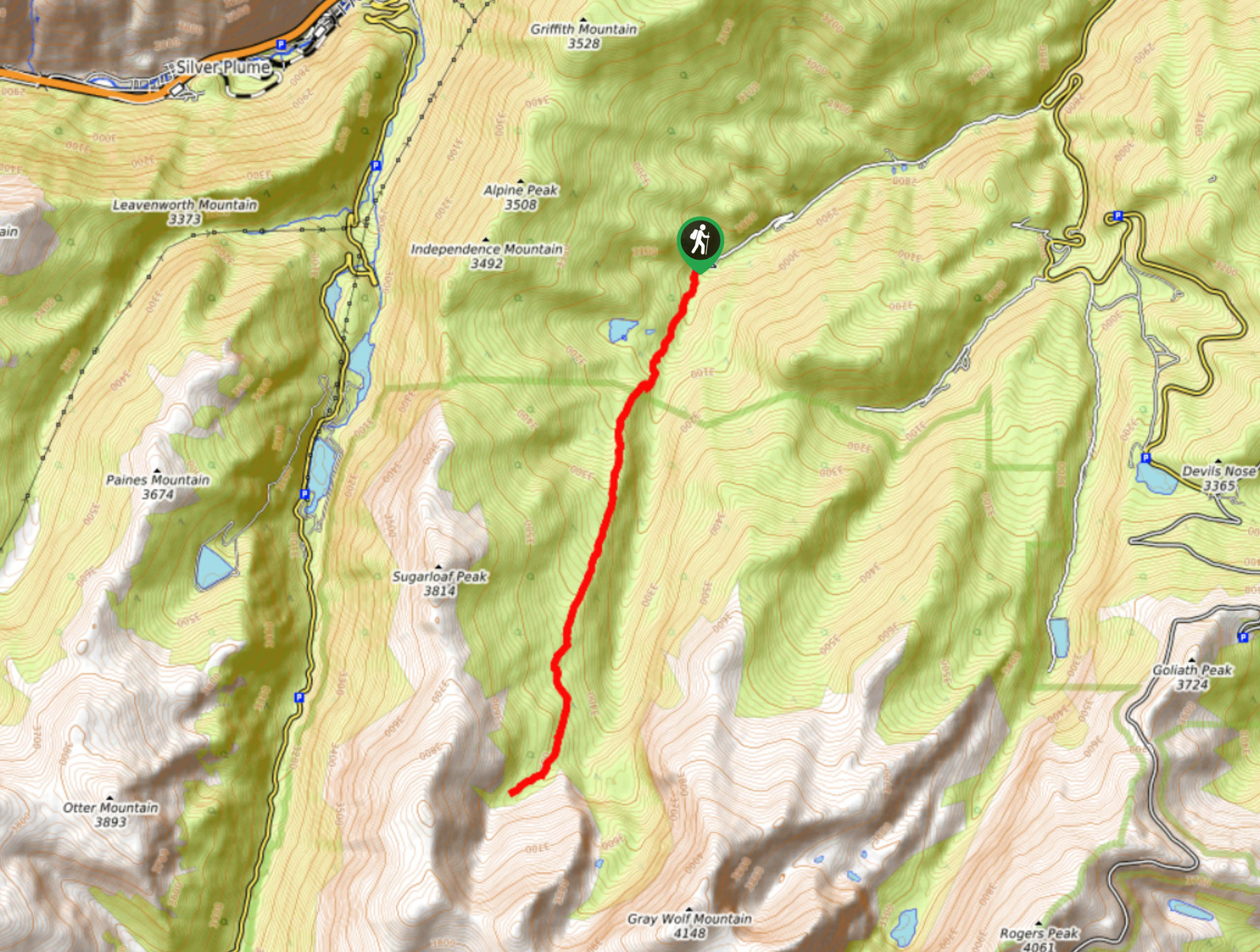
This adventure begins at the Hell’s Hole Hike Trailhead at the end of West Chicago Creek Road. Note the West Chicago Creek Road is subject to seasonal closures.

About
| Backcountry Campground | |
| When to do | March-October |
| Pets allowed | Yes - On Leash |
| Family friendly | Older Children only |
| Route Signage | Average |
| Crowd Levels | Extreme |
| Route Type | Out and back |
Hell’s Hole Hike
Elevation Graph
Weather
Hell’s Hole Hike Description
Hike along the soft forest floor, carpeted with aspen foliage, before summiting a rocky ridge at the base of one of Colorado’s 13ers. The Hell’s Hole Hike is a crowd favorite because it is the perfect balance between strenuous and scenic. The entirety of the trail gradually ascends towards the turnaround point, so pack plenty of water because you will surely break a sweat. Additionally, if you plan to hike in the autumn or winter months, microspikes and trekking poles are a must to navigate the slippery, rocky terrain. We recommend checking the weather before you embark on your adventure to avoid any afternoon storms and bring layers to withstand the hike’s windy conditions.
Start your hike along the Hell’s Hole Trail from the trailhead. From the trailhead, track south along the Hell’s Hole Trail. Hike along the trail as it guides you into a lush aspen grove. Climb up the path and you will shortly enter into the Mount Evans Wilderness. Hike along the forested aspen valley and it will eventually level out and the terrain will become increasingly rocky. As the aspens thin out you will be transferred into pine woodlands. Trek along the route until you reach the timberline.
At this point you will be rewarded with sights of alpine willow meadows and an up-close and personal view of Gray Wolf Mountain. Enjoy the grandeur of the rocky mountain and rest prior to your descent down the trail. When you are ready, simply retrace your steps along the path all the way back to the trailhead.
Similar hikes to the Hell’s Hole Hike hike

Hankins Pass Hike
The Hankins Pass Hike is a quintessential adventure across the Lost Creek Wilderness. The hike demonstrates the diversity of the…

Miller Gulch Loop Trail
The Miller Gulch Loop Trail is a scenic meadowland adventure in the Pike National Forest. Hike through grassy meadows laden…

The Castle Hike
The Castle Hike is an exciting adventure up the steep, forested terrain to The Castle Rock. From atop the summit,…
Comments