
Crown Point Trail to B-17 Crash Site
View Photos
Crown Point Trail to B-17 Crash Site
Difficulty Rating:
Hike the forestland path, up to Crown Point before descending to the remains of the B-17 crash site. History buffs and outdoor enthusiasts alike will enjoy this adventure along the Crown Point Trail to the B-17 Crash Site.
Getting there
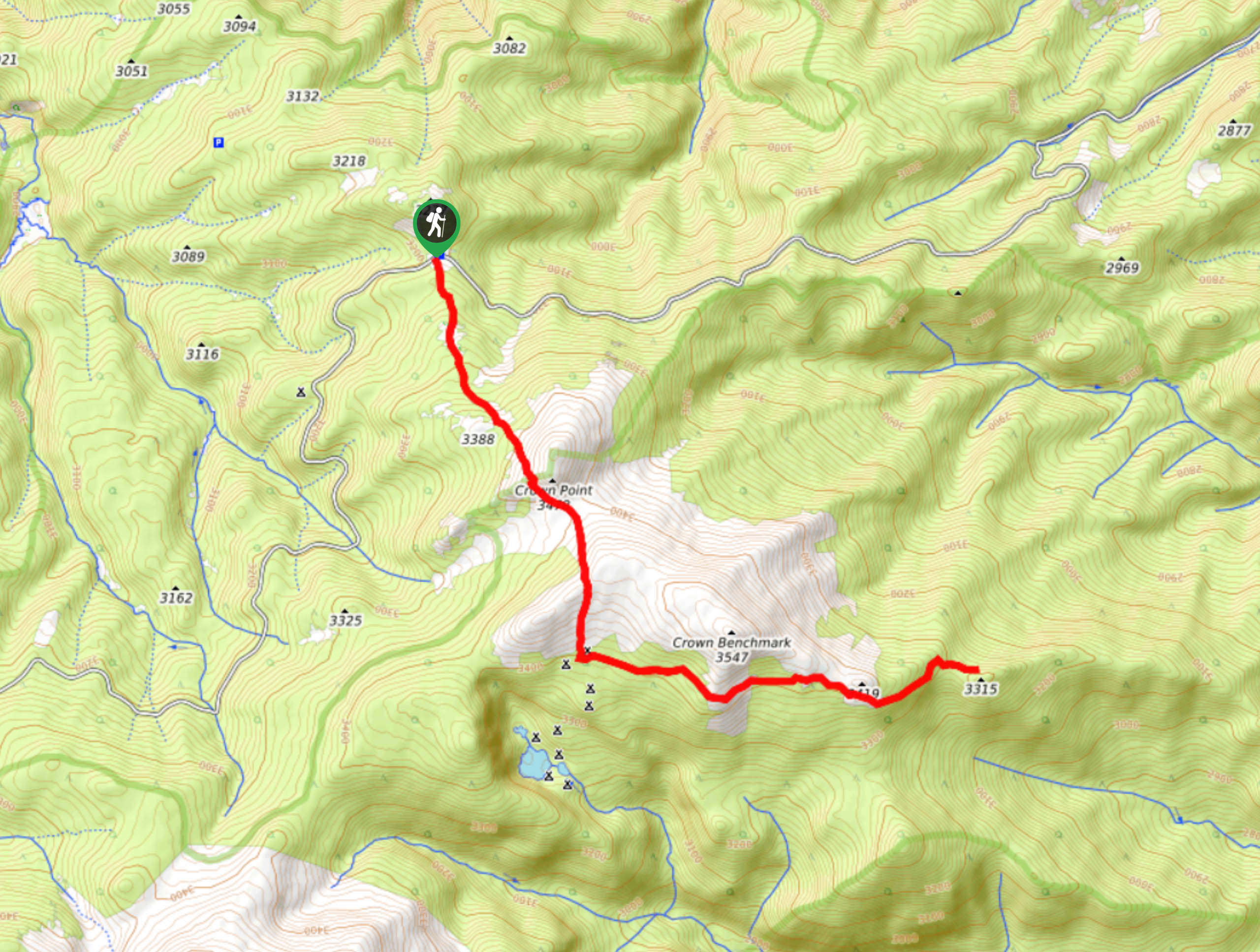
Crown Point Trail to the B-17 Crash Site Trailhead is located off Crown Point Road.

About
| Backcountry Campground | Dispersed Backcountry Camping, restrictions apply. |
| When to do | July-September |
| Pets allowed | Yes - On Leash |
| Family friendly | Older Children only |
| Route Signage | Average |
| Crowd Levels | Low |
| Route Type | Out and back |
Crown Point Trail to B-17 Crash Site
Elevation Graph
Weather
Crown Point Trail to the B-17 Crash Site Hike Description
The World War II bomber went down on June 4th, 1944, killing 4 of the 10 passengers onboard. To this day, jagged metal remains etched in the hillside. Adventure through the stunning Colorado woodlands over Crown point before exploring the sobering remains. This path is well-marked and easy to navigate, but it is lengthy. Ensure you have enough stamina to make it there and back!
Embark on your treasure hunt from the Crown Point Trailhead. The Crown Point Trail to the B-17 Crash follows the Browns Lake Trail for the first few kilometers. Hike along the path signposted as Browns Lake and trek through the dense pine forest. This path will weave you between meadowlands and tree shade as you near Crown Point. Ascend Crown Point and revel in the panoramic views from the overlook. Enjoy the vista, then continue down the saddle over to Crown Benchmark. At this point, you will meet an intersection, stay left and you will be diverted onto Flowers Trail.
Hike the exposed Flowers Trail over the ridge. The trail will then descend below the timberline to the B-17 Crash Site. Explore the eerie remains etched into the hillside. Adventure the crash site then retrace your steps along the path back to the trailhead.
Similar hikes to the Crown Point Trail to B-17 Crash Site hike

Hankins Pass Hike
The Hankins Pass Hike is a quintessential adventure across the Lost Creek Wilderness. The hike demonstrates the diversity of the…

Miller Gulch Loop Trail
The Miller Gulch Loop Trail is a scenic meadowland adventure in the Pike National Forest. Hike through grassy meadows laden…

The Castle Hike
The Castle Hike is an exciting adventure up the steep, forested terrain to The Castle Rock. From atop the summit,…
Comments