Mummy Pass Trail
View Photos
Mummy Pass Trail
Difficulty Rating:
Hike the Mummy Pass Hike through the diverse Colorado wilderness. Hike from the wilderness, through subalpine forests, up the alpine tundra and to a Rocky Mountain overlook. This exceptional backcountry adventure is reserved for experienced hikers who don’t mind a bit of a challenge. We love this trail, and we think that you might too.
Getting there
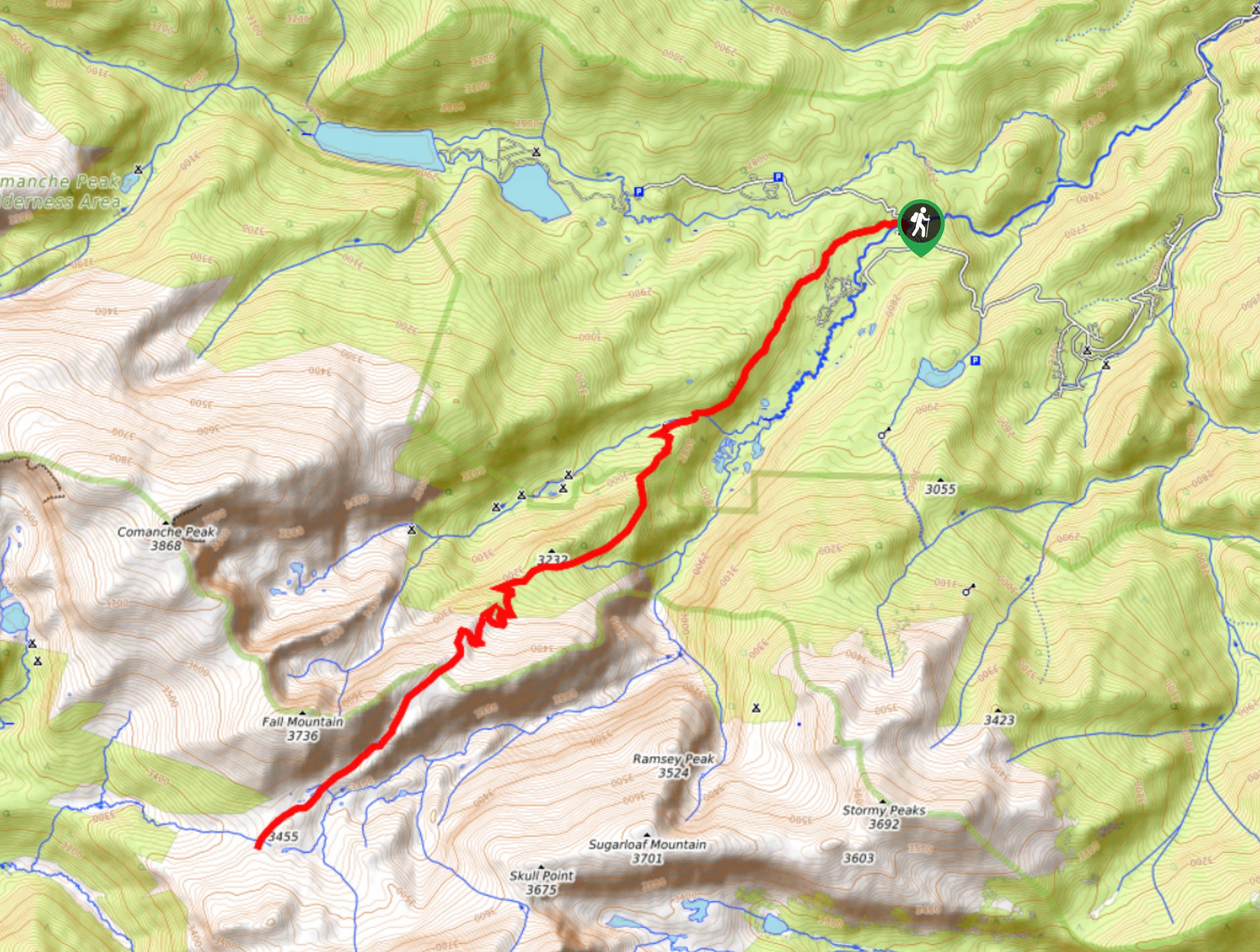
The Mummy Pass Hike begins at the Tom Bennett Campground off Forest Development Road 145.

About
| Backcountry Campground | Dispersed Backcountry Camping, restrictions apply. |
| When to do | April-November |
| Pets allowed | Yes - On Leash |
| Family friendly | No |
| Route Signage | Average |
| Crowd Levels | Low |
| Route Type | Out and back |
Mummy Pass Trail
Elevation Graph
Weather
Mummy Pass Hike Description
Hike through the subalpine terrain through the Comanche Peak Wilderness to the Rocky Mountain National Park. Walk up the Mummy Pass through the alpine tundra, amongst marmots and moose before summiting one of the most impressive Mummy Range overlooks. Hikers will ascend high altitudes along this trail so ensure to wear layers and consider microspikes to navigate the snowy and icy terrain at the summit. Note that overnight stays in the Rocky Mountain National Park require a permit.
Begin your excursion up the Mummy Pass Trail from the Tom Bennett Campground. From the campground, take the trail signposted Emmaline Lake. Hike up this path, ignoring intersecting routes near the Colorado State University Mountain Campus. Trek along this route through the forestlands along Fall Creek. At the junction, veer left, and you will be diverted onto the Mummy Pass Trail. Hike this path as it ascends the timberline. Navigate the rocky switchbacks into the Rocky Mountain National Park and alpine terrain. Here, the trail will plateau as you track along the pass.
You will come to the trail’s end when you intersect with Mummy Pass Creek. Revel in the expansive vistas of the Rocky Mountain National Park and the encompassing snow-capped peaks. When you are ready to return, retrace your steps along the route to the campground and trailhead.
Similar hikes to the Mummy Pass Trail hike

Hankins Pass Hike
The Hankins Pass Hike is a quintessential adventure across the Lost Creek Wilderness. The hike demonstrates the diversity of the…

Miller Gulch Loop Trail
The Miller Gulch Loop Trail is a scenic meadowland adventure in the Pike National Forest. Hike through grassy meadows laden…

The Castle Hike
The Castle Hike is an exciting adventure up the steep, forested terrain to The Castle Rock. From atop the summit,…
Comments