
Button Rock Mountain Trail
View Photos
Button Rock Mountain Trail
Difficulty Rating:
Put your navigational skills to the test as you maneuver the network off trails that lead up to the summit of Button Rock. The Button Rock Mountain Trail is a stimulating adventure through the Roosevelt National Forest that will guide you through diverse Colorado terrains up to a stunning overlook. Lace up those hiking shoes and get your GPS ready!
Getting there
The Button Rock Mountain Trailhead is off Big Elk Road.

About
| Backcountry Campground | Dispersed Backcountry Camping, restrictions apply. |
| When to do | June-October |
| Pets allowed | Yes - On Leash |
| Family friendly | Older Children only |
| Route Signage | Poor |
| Crowd Levels | Low |
| Route Type | Lollipop |
Button Rock Mountain Trail
Elevation Graph
Weather
Button Rock Mountain Hike Description
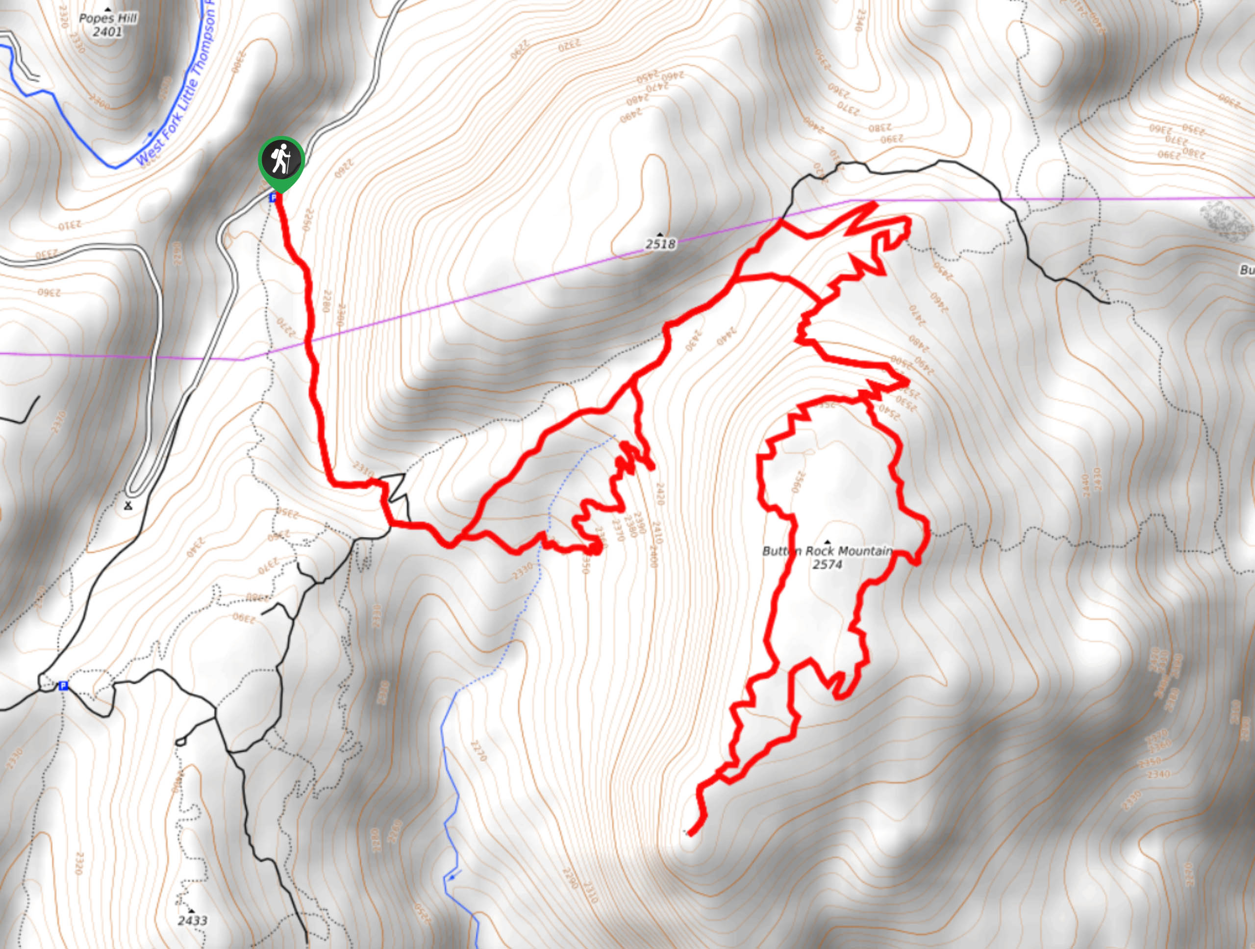
Hike through the dense pine woodlands along the Button Rock Mountain Trail. This network of paths is primitive, and many of them are unmarked. We highly suggest using the Trail GPS to help you navigate this forested adventure. Note that mountain bikers also utilize this path, so be mindful and respectful of those you share the trails with. Hike through the forestland and notice the vibrant wildflowers that line the path in the warmer months. There is only one stream crossing at the beginning of the hike, so pack plenty of water to keep hydrated along this journey.
From the trailhead and parking lot, track the unmarked trail on the left. Hike up the wooded route at the first set of intersecting paths, keep straight Loose Button Trail. Cross over RattleSnake Gulch Creek and ascend the path. Keep along this path, ignoring the merging Happy Ending Trail. Hike northeastward and at the next junction stay left, then take a right at the one soon after. This trail will guide you up to another fork in the road. Take a right and hike up the Button Rock summit route. Ascend the path and navigate the switchbacks. You can complete the summit loop from either direction at the next intersection, but we went clockwise. Hike around the Button Rock Mountain Loop Trail around the granite summit. Explore the rock outcroppings and enjoy the expansive vistas from atop the mountain.
Complete the loop, then hike back down the unmarked trail you ascended earlier. Descend the switchbacks, and at the junction, veer left. Head left again at the next turn and then right at the Loose Button Trail junction. Hike down the forested path along the RattleSnake Gulch Creek. At this point, you will meet back up with the unmarked trail that departed from the trailhead. Turn right and follow the path back to the parking lot.
Similar hikes to the Button Rock Mountain Trail hike

Hankins Pass Hike
The Hankins Pass Hike is a quintessential adventure across the Lost Creek Wilderness. The hike demonstrates the diversity of the…

Miller Gulch Loop Trail
The Miller Gulch Loop Trail is a scenic meadowland adventure in the Pike National Forest. Hike through grassy meadows laden…

The Castle Hike
The Castle Hike is an exciting adventure up the steep, forested terrain to The Castle Rock. From atop the summit,…
Comments