Bulwark Ridge Trail
View Photos
Bulwark Ridge Trail
Difficulty Rating:
There is no doubt about it, you will surely break a sweat as you ascend the Bulwark Ridge Trail in the Roosevelt National Forest. This woodland hike will push you out of your comfort zone and will have you sucking wind as you climb over 3281ft in elevation. Reserved for experienced hikers and those seeking a challenge, the Bulwark Ridge Hike will reward its conquerors with breathtaking Front Range vistas.
Getting there
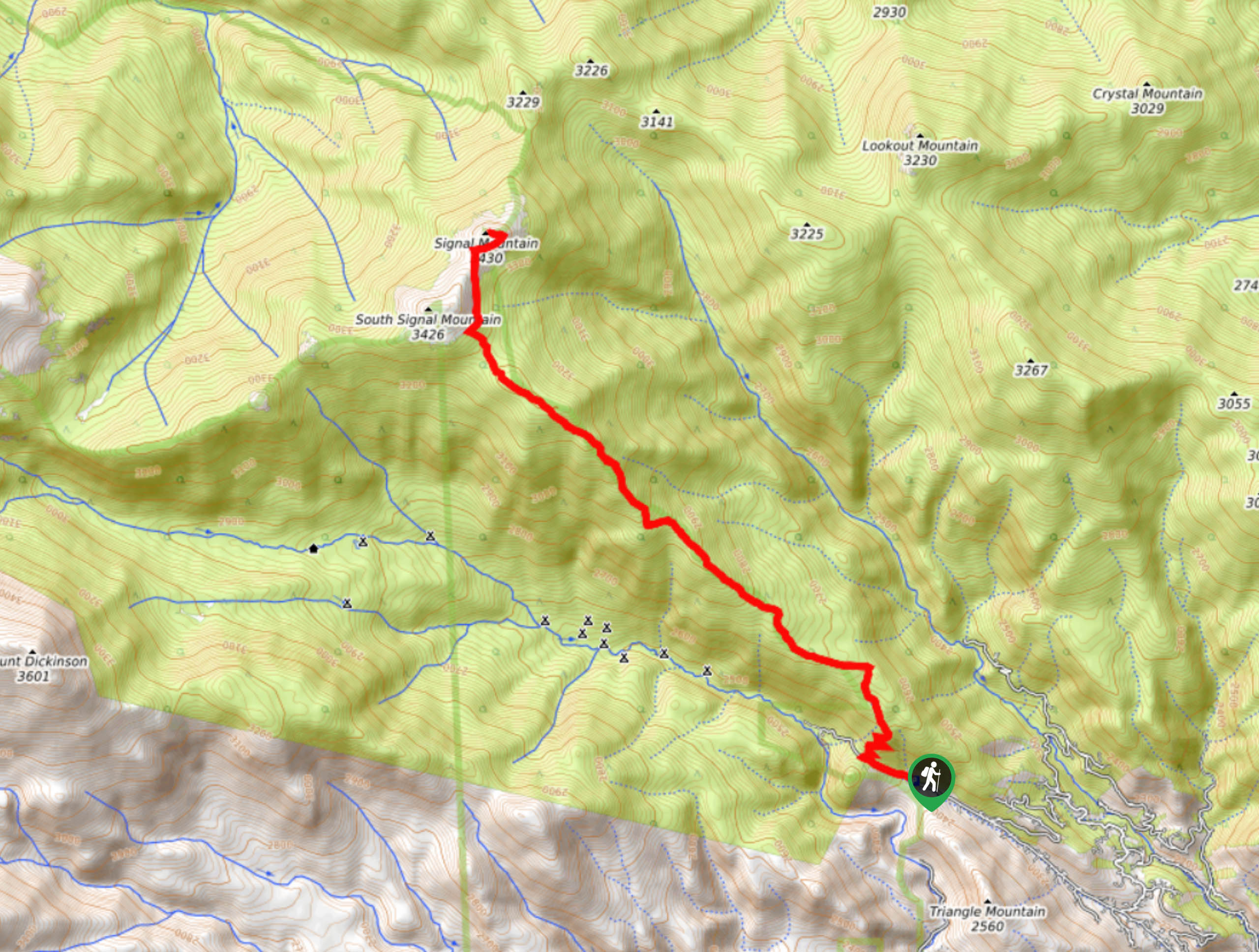
The Bulwark Ridge Trailhead is located at the end of Dunraven Glen Road.

About
| Backcountry Campground | Dispersed backcountry camping, restrictions apply. |
| When to do | Year-round |
| Pets allowed | Yes - On Leash |
| Family friendly | No |
| Route Signage | Average |
| Crowd Levels | Low |
| Route Type | Out and back |
Bulwark Ridge Trail
Elevation Graph
Weather
Bulwark Ridge Hike Description
The scenic hike up the Bulwark Ridge Trail is well-worth the exhaustion. This incredibly beautiful wilderness trail was unfortunately damaged in the Cameron Peak Fire in 2020. The route has since reopened but few forested sections are completely burned. Use your discretion and consider saving this hike for a calm day to avoid the chances of burned trees falling in the wind. Much of the path remains untouched, but due to the burn, there are plenty of exposed segments of the route. Make sure to wear layers to protect against the windy weather as you climb altitude. Note there is some scrambling required up steep terrain near the summit of Signal Mountain, we recommend sturdy hiking boots and trekking poles to help you navigate these sections.
Beginning from the parking lot, track up the Dunraven Glade Road until you meet the Bulwark Ridge Trailhead. From the trailhead, the path follows a steep route up several switchbacks. Navigate the switchbacks up the ridge and continue along the Bulwark Ridge Trail as it guides you through the woodlands. Hike up the route as it intersects with a small alpine creek on several occasions. Travel up the forestland, and through the eerie burn. Continue up the path and as you gain elevation, the route will become increasingly exposed. Now rocky, the trail will lead you up the steep Bulwark Ridge and through the saddle between South Signal Mountain and Signal Mountain. Hike along the boundary of the Rocky Mountain National Park before the path diverts you northeast up Signal Mountain.
Scramble up the mountainside and summit Signal Mountain. Enjoy the expansive panorama of the Rocky Mountains and the verdant woodlands below. Take a moment to appreciate what you just accomplished before beginning your return. When you have rehydrated and refueled, retrace your steps all the way back to the trailhead and car park.
Similar hikes to the Bulwark Ridge Trail hike

Hankins Pass Hike
The Hankins Pass Hike is a quintessential adventure across the Lost Creek Wilderness. The hike demonstrates the diversity of the…

Miller Gulch Loop Trail
The Miller Gulch Loop Trail is a scenic meadowland adventure in the Pike National Forest. Hike through grassy meadows laden…

The Castle Hike
The Castle Hike is an exciting adventure up the steep, forested terrain to The Castle Rock. From atop the summit,…
Comments