
Mount Woodside Trail
View Photos
Mount Woodside Trail
Difficulty Rating:
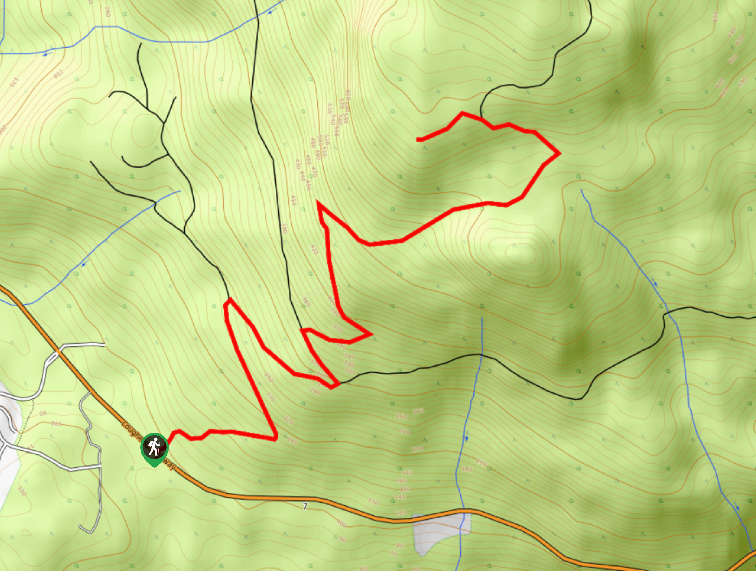
The hike up Mount Woodside is a solid out-and-back route in the Fraser Valley due to the steep incline along the entirety of the trail. Climbing uphill for 6.0mi, you will pass through beautiful stretches of forest until you reach the hang glider launch area. From this vantage point, you will have an amazing view over the valley and will be able to watch adventurous hang gliders as they soar through the air.
Getting there
To reach the Mount Woodside trailhead from Agassiz, drive northwest on BC-7 for 0.9mi and turn left to continue along the highway. Continue straight for another 6.2mi, where you will find the trailhead on your right.

About
| When to do | May-November |
| Backcountry Campsites | No |
| Pets allowed | Yes - On Leash |
| Family friendly | No |
| Route Signage | Average |
| Crowd Levels | Low |
| Route Type | Out and back |
Mount Woodside Trail
Elevation Graph
Weather
Mount Woodside Trail Description
The trail up Mount Woodside is a hike in the Fraser Valley that climbs uphill along a steep grade to reach a launch area for hang gliders. The route winds uphill through the trees along a forest service road to the beautiful vantage point that overlooks the Fraser Valley. If you time your hike properly, you can even watch some of the adventurous hang gliders as they launch themselves off Mount Woodside and glide above the scenic landscape below. Bring bug spray for the mosquitoes and water for the lack of shade on this hike. Following the trail is extremely easy as you’ll be hiking along an obvious dirt road the entire time.
For those looking to extend their hike, there is also the option to continue along the trail further up the mountain to reach the summit. Some hikers prefer the view from the hang glide launch pad.
Similar hikes to the Mount Woodside Trail hike

Chipmunk Creek Trail
Hike along the Chipmunk Creek Trail to experience the feeling of solitude along the trail while taking in scenic views…

Matsqui Trail
The Matsqui Trail is a 16.7mi multi-use trail that travels alongside the Fraser River and provides nice views…

Flora Peak Trail
The Flora Peak Trail is an 7.1mi out-and-back hiking route that will take you through dense forests and…
Comments