
Goat Ridge
View Photos
Goat Ridge
Difficulty Rating:
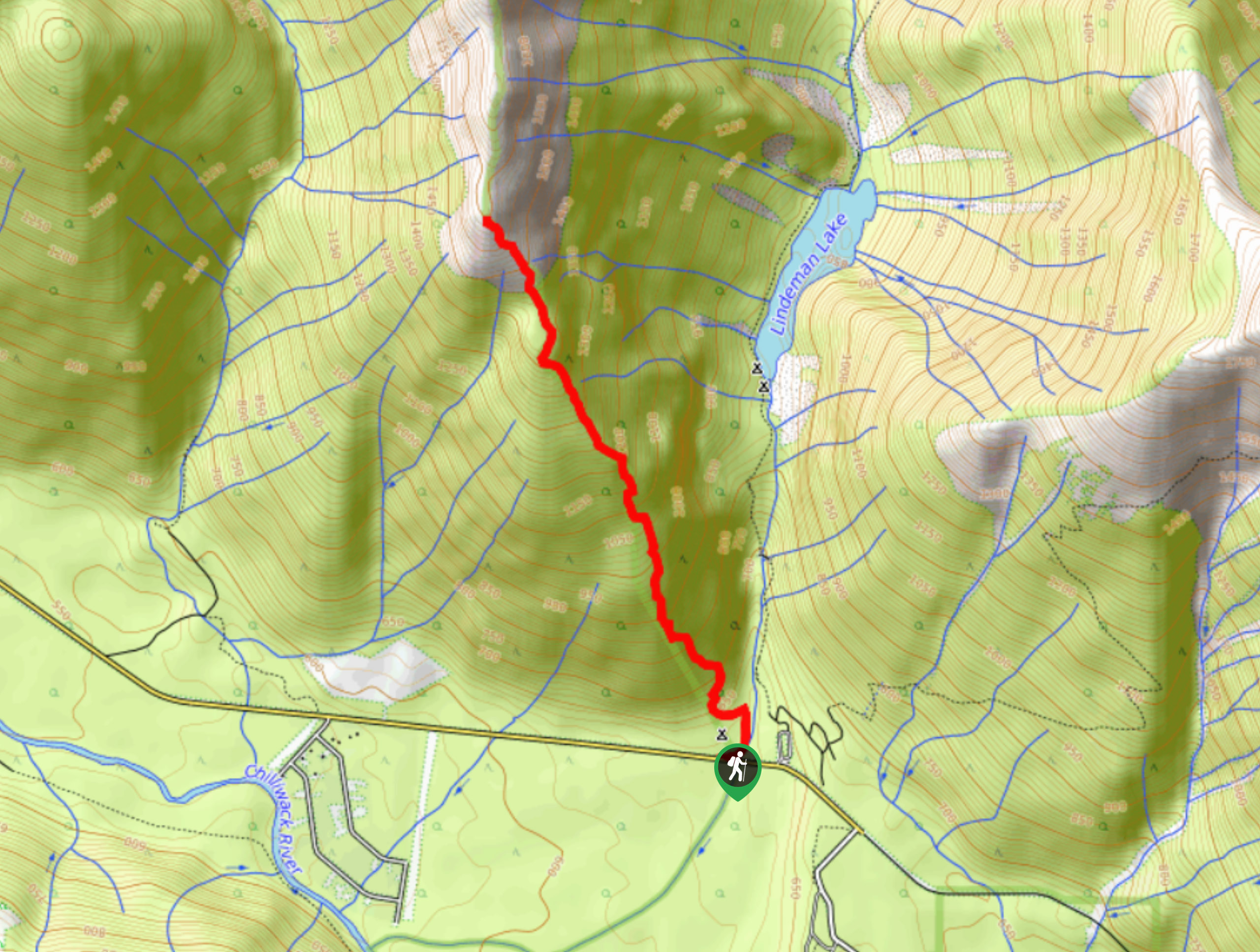
The hike up Goat Ridge is a steep climb that will take you through the beautiful forests found near Chilliwack Lake Provincial Park. This 8km out-and-back trail is fairly technical and contains several roped sections to aid your climb. When you reach the top of the ridge you can expect to see amazing views of the mountains and lakes in the surrounding area.
Getting there
To reach the Goat Ridge trailhead from Chilliwack, drive south on Vedder Road and take the second exit on the roundabout. Once you are on Chilliwack Lake Road, continue on for 24.5mi to where the trailhead can be found on the left side of the highway.

About
| When to do | June-October |
| Backcountry Campsites | No |
| Pets allowed | Yes |
| Family friendly | No |
| Route Signage | Average |
| Crowd Levels | Low |
| Route Type | Out and back |
Goat Ridge
Elevation Graph
Weather
Goat Ridge Trail Description
The hike up Goat Ridge is a steep route near Chilliwack Lake Provincial Park that will take hikers up to two scenic lookouts before reaching the top of the ridge. The trailhead can be a bit tricky to find, as it is located in a heavily forested area just off the side of the highway and once you do find it, you will set off on a very steep incline up to the ridge. Along the route there are five technical sections with rope installations to help with traversing some large rock formations.
Once you reach the lookouts, you will have amazing views over the Chilliwack, Lindeman, and Greendrop lakes, as well as nearby mountains like Mount Webb and Mount Meroniuk. From the top of the ridge, you will have even more beautiful views that reach out in every direction. This hike may be tough, but it is an amazingly scenic climb that is less busy than other routes in the Chilliwack Lake area.
Similar hikes to the Goat Ridge hike
Popkum Community Trail
Hike along the Popkum Community Trail for a fun and educational experience where you can learn about the wildlife and…
Fishtrap Creek Loop
Hiking the Fishtrap Creek Loop in Abbotsford is a great way to get out and explore the natural beauty of…

Matsqui Trail
The Matsqui Trail is a 16.7mi multi-use trail that travels alongside the Fraser River and provides nice views…
Comments