
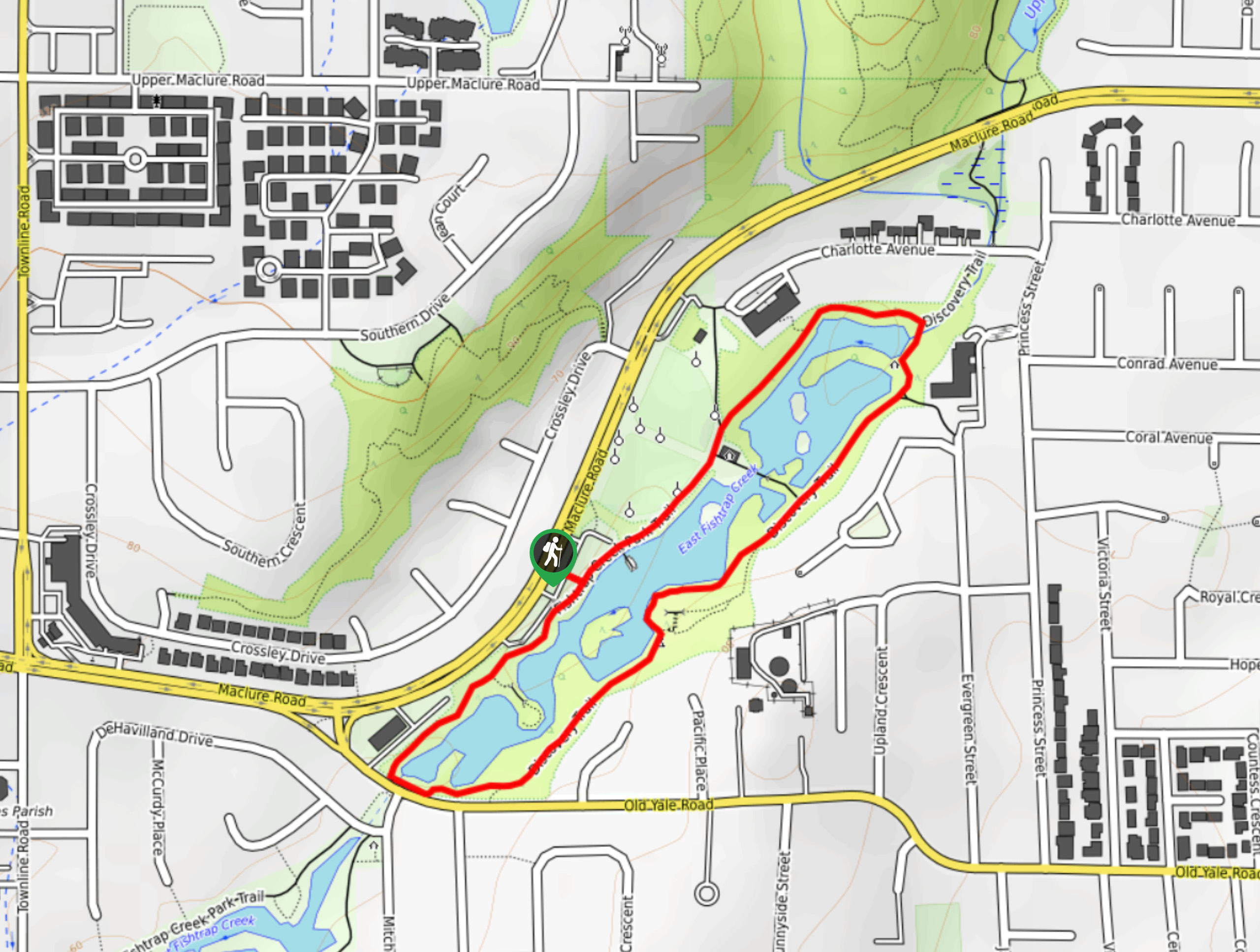
Fishtrap Creek Loop
View Photos
Fishtrap Creek Loop
Difficulty Rating:
Hiking the Fishtrap Creek Loop in Abbotsford is a great way to get out and explore the natural beauty of this city. The quick 1.2mi loop trail follows closely alongside the edge of the creek and provides hikers with scenic waterside views and a pleasant atmosphere for an outdoor stroll. Make sure to utilize the viewpoints over the creek for a chance to spot some of the many local wildlife species that can be found within the park.
Getting there
To reach the parking area for the Fishtrap Creek Loop from central Abbotsford, drive west on S Fraser Way and make a slight right onto Old Yale Road. After 1.1mi, make a right onto Maclure Road, where you will find the parking lot on your right in 755ft.

About
| When to do | Year-Round |
| Backcountry Campsites | N |
| Pets allowed | Yes - On Leash |
| Family friendly | Yes |
| Route Signage | Average |
| Crowd Levels | Moderate |
| Route Type | Circuit |
Fishtrap Creek Loop
Elevation Graph
Weather
Fishtrap Creek Trail Description
The Fishtrap Creek Loop is a beautifully scenic walking route in Abbotsford that covers a stretch of waterside trail in this lovely city park. The paved path along this route is almost entirely flat, making for a trail that is suitable for hikers of all skill levels, including families with young children. As you make your way around the water’s edge, you will be surrounded by a peaceful forest setting and enjoy nice views across the creek. Along the trail, you will also be able to utilize several lookouts where you can spot local wildlife, such as rabbits, beavers, frogs, and ducks. This short route is perfect for an afternoon/weekend nature excursion without leaving the city.
Similar hikes to the Fishtrap Creek Loop hike
Popkum Community Trail
Hike along the Popkum Community Trail for a fun and educational experience where you can learn about the wildlife and…

Matsqui Trail
The Matsqui Trail is a 16.7mi multi-use trail that travels alongside the Fraser River and provides nice views…
Dewdney Grind Trail
Hiking the Dewdney Grind is a challenging affair due to the steep incline and heavily-forested nature of the trail. Along…
Comments