
Bear Mountain Loop
View Photos
Bear Mountain Loop
Difficulty Rating:
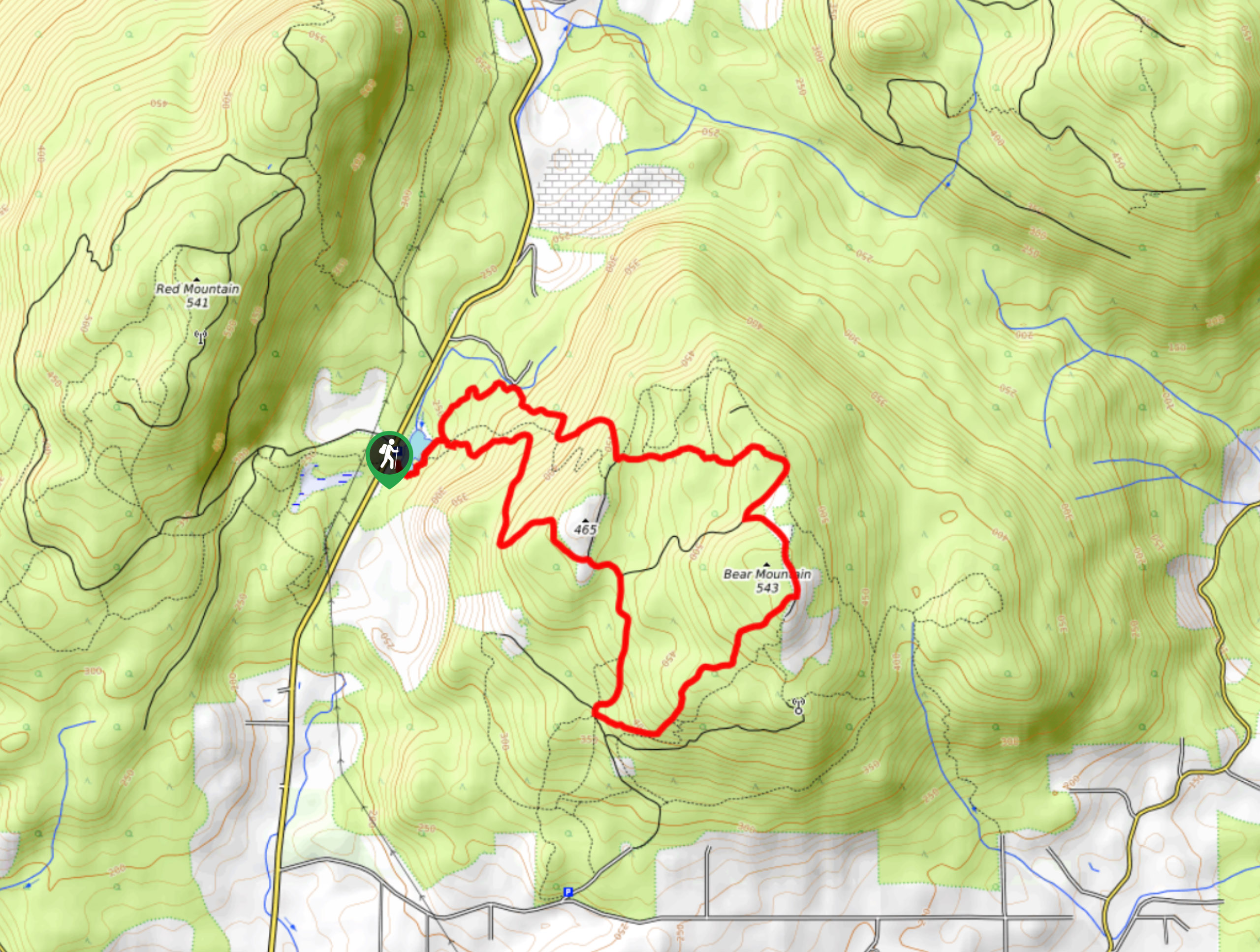
The Bear Mountain Loop is a forested hiking route just north of Mission, BC that can be utilized by either hikers or mountain bikers. This 5.5mi path climbs through a beautiful forest to the summit of Bear Mountain and provides nice views of the surrounding area. Try not to get lost on this dense network of trails!
Getting there
To reach the parking area at Bear Mountain from Mission, drive north on Cedar Street for 2.0mi and turn left onto Dewdney Trunk Road. After 0.9mi, turn right to stay on Dewdney Trunk Road, where you will find the parking lot on your right in 1.7mi.

About
| When to do | Year-Round |
| Backcountry Campsites | N |
| Pets allowed | No |
| Family friendly | Older Children only |
| Route Signage | Poor |
| Crowd Levels | Moderate |
| Route Type | Circuit |
Bear Mountain Loop
Elevation Graph
Weather
Bear Mountain Trail Description
The Bear Mountain Loop is part of a dense network of hiking and mountain biking trails just north of Mission, BC that meander around the slopes of Bear Mountain. As there are a lot of intersecting routes, it’s best to bring a GPS or trail map in order to stay on the correct path. The trail sets out from the parking area next to Mill Pond and climbs through a scenic stretch of forest on the way to the summit.
Along the trail you will be able to take in the beautiful forest setting and look out over the Fraser Valley and its surrounding mountains from a scenic lookout. Continuing down the forested trail, you will eventually complete the loop and arrive back at Mill Pond. As this is a multi-use trail, make sure to keep an eye out for mountain bikes and remember to share the trail.
Similar hikes to the Bear Mountain Loop hike

Chipmunk Creek Trail
Hike along the Chipmunk Creek Trail to experience the feeling of solitude along the trail while taking in scenic views…

Matsqui Trail
The Matsqui Trail is a 16.7mi multi-use trail that travels alongside the Fraser River and provides nice views…

Flora Peak Trail
The Flora Peak Trail is an 7.1mi out-and-back hiking route that will take you through dense forests and…
Comments