
Tunnel Spring Hike
View Photos
Tunnel Spring Hike
Difficulty Rating:
Some hikes are just made for quiet mornings, and Tunnel Spring is one of them. This is a relaxing route through the forest that leads you to the top of Observatory Mesa. While the views aren’t the most far-reaching around, this hike amongst the trees is very pleasant. It’s a steady climb up, but once you’re on the mesa you can stroll quite a ways along its flat top. Expect moderate traffic on this route.
This hike crosses the train tracks, and if your kids like trains, there’s a good chance you might spot one or two. While train tracks near a nature hike might seem like an unlikely combo, it’s a fun feature and watching the trains cruise by can be enjoyable. Once you’re on the mesa, you’ll feel far away from the city.
Getting there
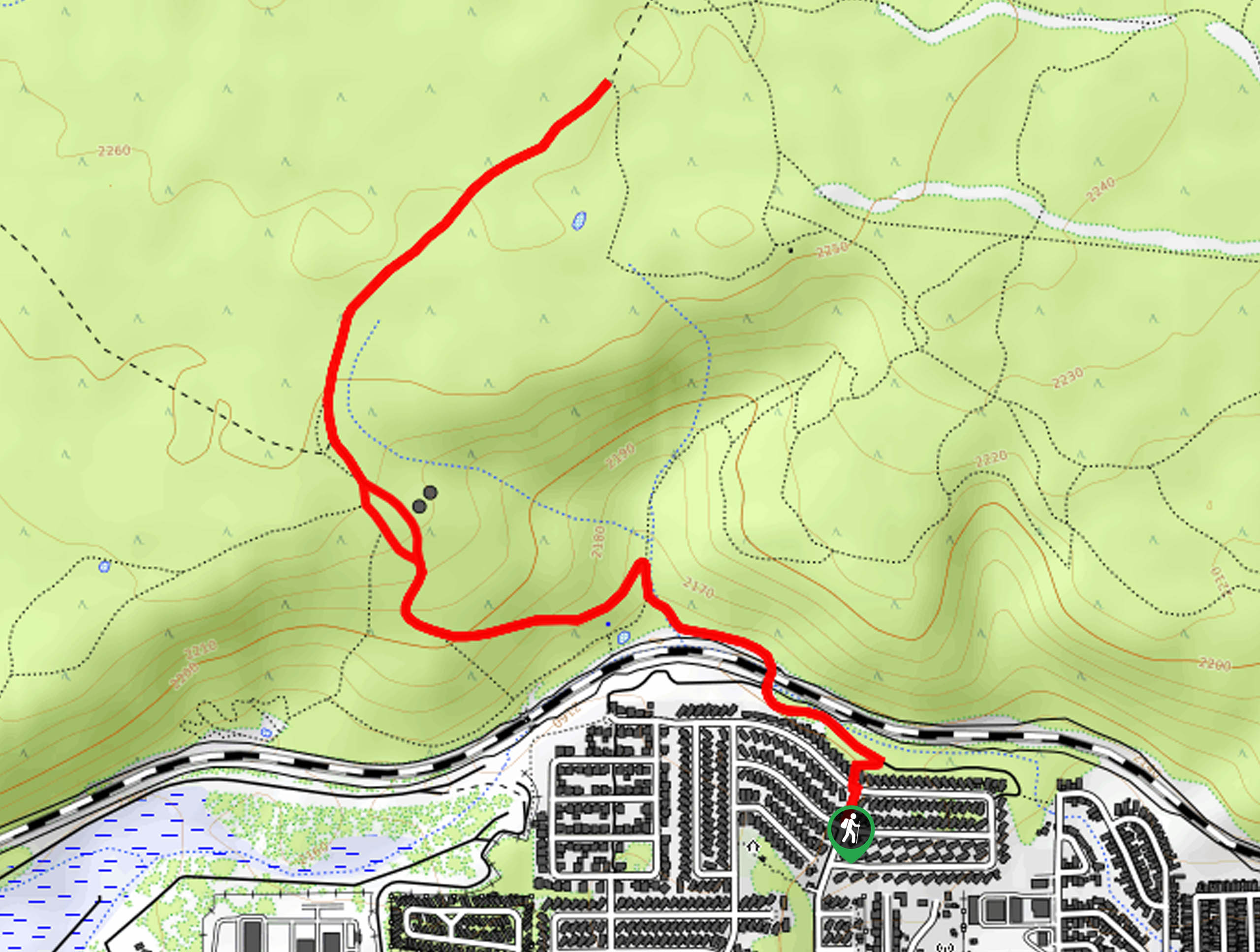
The trailhead for the Tunnel Spring hike is on S Railroad Spring road.

About
| Backcountry Campground | No |
| When to do | March-November |
| Pets allowed | Yes - On Leash |
| Family friendly | Yes |
| Route Signage | Poor |
| Crowd Levels | Moderate |
| Route Type | Out and back |
Tunnel Spring Hike
Elevation Graph
Weather
Tunnel Spring Hike Description
The Tunnel Spring hike is a hike that straddles the line between urban and remote. While it’s just minutes from busy Route 66 and easily reached in Flagstaff, it quickly makes you feel like you’re a ways away from the city. With an enjoyable trek through the ponderosa pines stretched ahead of you, this is a pleasant trip that won’t take all day to get to or enjoy.
This is a particularly nice hike to plan for a quiet morning. Something about the forest, the sunrise, and the usual lack of people makes this route best early in the day. You will need to plan for the mosquitoes in the summertime, though. For some reason, they’re relentless in this area.
The beginning of the Tunnel Spring hike crosses train tracks, and it’s not unusual to have a train or two pass by, which can be quite fun for little kids. Rest assured that once you’re up on the mesa, you’ll feel far away from the noise of the trains and the city.
The signage on this route is fairly poor and there are several unmarked junctions. Consider downloading your GPS track ahead of time to help mitigate navigational challenges.
From the trailhead, take the walkway between the houses to the road that runs parallel to the train tracks. Take a left here, passing through the tunnel. Take another left and go through a gate.
You’ll want to stay right onto the wide road heading uphill. The elevation gain is all behind you once you’ve crested the mesa. Atop the mesa, the trail heads northeast past the Lowell Tank.
Past the tank, the route terminates at the unsigned junction with Mars Hill Trail. If you’ve got a map or a good familiarity with this area, it’s possible to continue hiking for quite some time on the network of trails up here. Most of the routes are east of where you are, although there are a few that run west, too.
Whenever you’re ready, the route down the mesa follows the same path you took up.
Hiking Route Highlights
Observatory Mesa
The Observatory Mesa Natural Area is a 2,251-acre area acquired by the City of Flagstaff in 2013 from the Arizona State Land Department. This mesa sits northwest of the city of Flagstaff, and many hiking trails have been developed on it. Mostly covered in ponderosa pine forest, the mesa has become a popular recreational area, and in addition to trails, it also hosts the Lowell Observatory.
Frequently Asked Questions
Where do I park for the Tunnel Spring hike?
You’ll need to park on a residential street for this hike. Take care not to block any driveways.
Is the Tunnel Spring hike dog-friendly?
Yes, leased dogs are allowed on this trail.
Insider Hints
Keep an eye out for mule deer and elk on this hike.
If you can get on top of the mesa early enough, this is a lovely trail to watch the sunrise from.
Similar hikes to the Tunnel Spring Hike hike

Fay Canyon Loop
Fay Canyon is one of several main canyons in the Walnut Canyon National Monument. This loop hike explores part of…

Sandy Steps, Heart, and Upper Oldham Trail
The Sandy Steps, Heart, and Upper Oldham hike makes use of several different trails to create a hike that stretches…

Fisher Point via Fay Canyon
Fisher Point is one of the best viewpoints into the gorgeous Walnut Canyon. This route leads you to the point…
Comments