
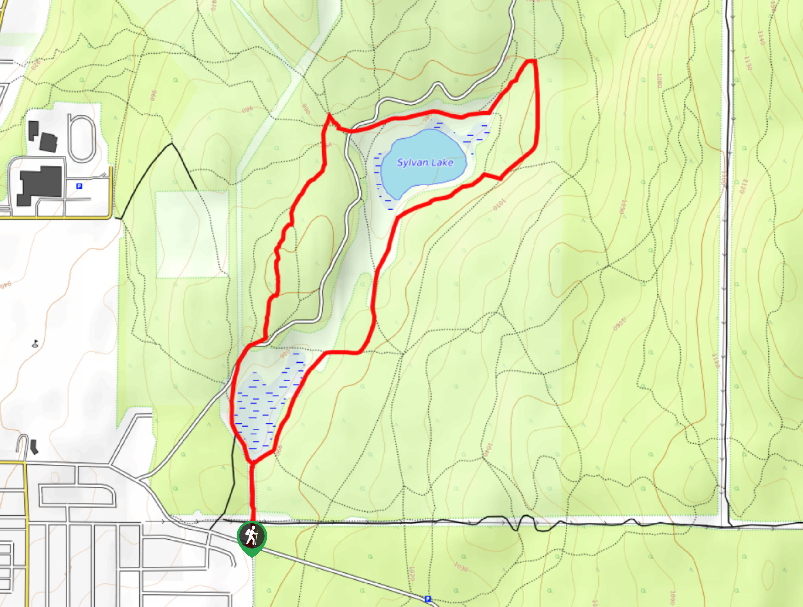
Sylvan Trail Loop
View Photos
Sylvan Trail Loop
Difficulty Rating:
The Sylvan Trail Loop is a 3.0mi lollipop hiking route in Cranbrook, BC, that will allow you to explore the beautiful forests to the east of the city before arriving at the picturesque shores of Sylvan Lake. Once there, hikers will enjoy amazingly scenic views of the meadows surrounding the lake that are framed by thick forests and rugged mountain peaks in the backdrop. Make sure to arrive early or at off-peak times, as parking for this hike can be limited at popular times.
Getting there
To reach the parking lot and trailhead for the Sylvan Trail Loop from the BC-95 highway in Cranbrook, drive east along 2nd Street S for 2.1mi, making a left turn to enter the parking area.

About
| When to do | April-September |
| Backcountry Campsites | No |
| Pets allowed | Yes |
| Family friendly | Yes |
| Route Signage | Average |
| Crowd Levels | Moderate |
| Route Type | Lollipop |
Sylvan Trail Loop
Elevation Graph
Weather
Sylvan Trail Loop
Hiking the Sylvan Trail Loop is a short and fun outdoor experience that will take you to a beautiful meadow surrounding the charming shores of Sylvan Lake. With a trail made up of easy-to-navigate and relatively flat terrain, this hike is perfectly suited for hikers of all skill levels.
The trail sets out from the parking area and heads north along a cleared path through the forest. When you reach a fork in the trail next to the First Alkali Pond, head left and follow the trail into the thick cover of the forest. Take some time enjoying the serene atmosphere of the forest setting before you eventually break from the tree cover into a picturesque meadow. As you work your way around the edge of the meadow, you will have some amazing views overlooking the calm waters of Sylvan Lake. You will quickly enter back into the forest and begin your return leg of the hike. After meeting back with the original junction near the pond, follow the trail to return to your vehicle in the parking area.
Similar hikes to the Sylvan Trail Loop hike

Spirit Trail Loop
The Spirit Trail Loop is a 10.1mi hiking circuit in the East Side Columbia Lake Wildlife Management Area,…

Ram Creek Hot Springs
Hiking to the Ram Creek Hot Springs will take you on an 6.9mi out-and-back trail that runs along…
Kimberley Nordic Centre Trail
The Kimberley Nordic Centre Trail is an 5.2mi hiking circuit in Kimberley, BC, that will take you through…
Comments