
Eager Hill via Waterpark Trail
View Photos
Eager Hill via Waterpark Trail
Difficulty Rating:
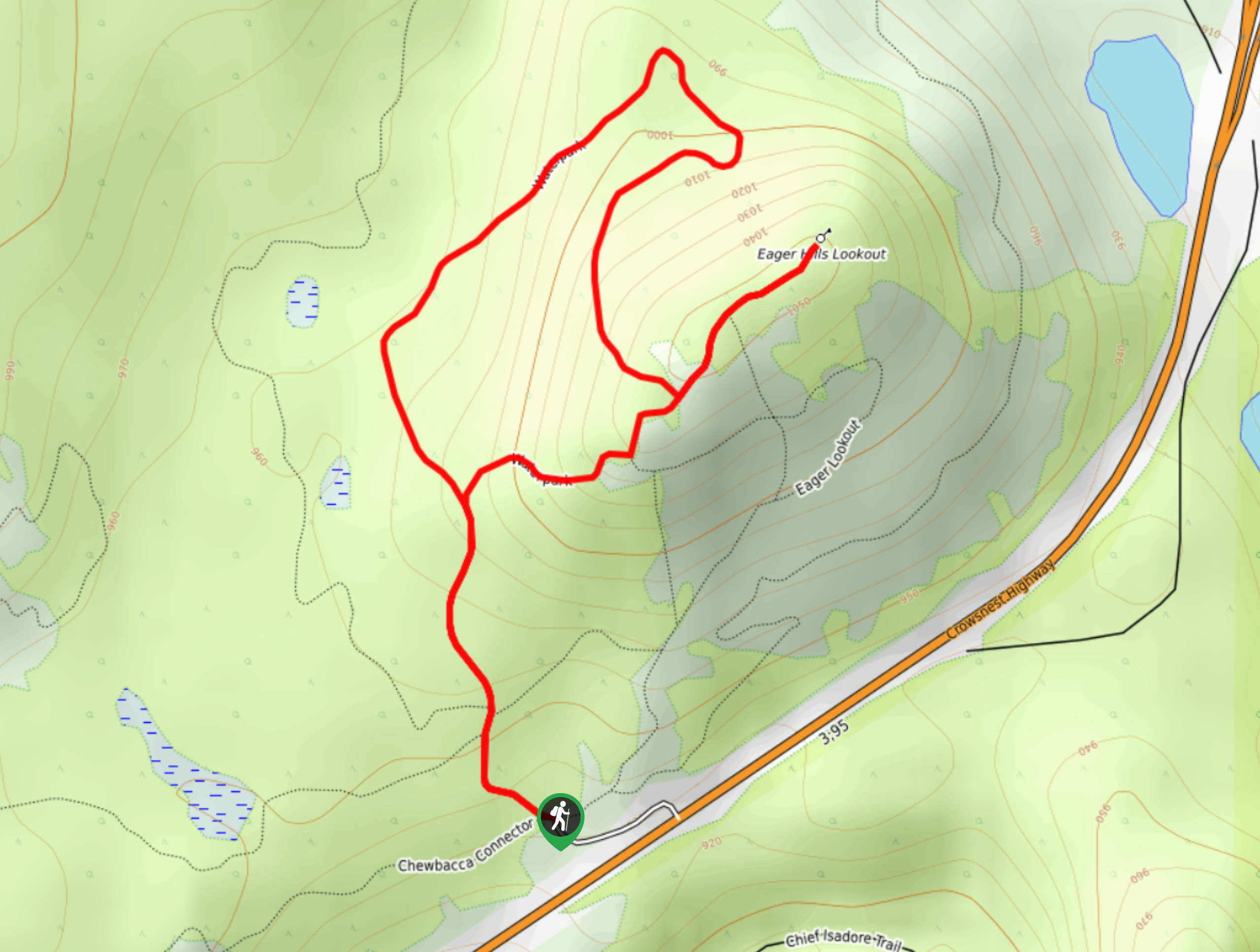
The Eager Hill via Waterpark Trail is a scenic lollipop hiking route that winds 2.1mi through the Cranbrook Community Forest Recreation Site to reach a lovely vantage point with spectacular views. Hikers utilizing this trail will experience a peaceful forest setting, as well as a sightline that stretches across the Kootenay River Valley toward the rugged expanse of the Canadian Rockies. Although short and fairly easy, some steep sections of trail along this may restrict mobility for some hikers.
Getting there
To reach the parking area for Eager Hill via Waterpark Trail from Cranbrook, drive northeast along BC-95 for 4.0mi and turn left to enter the parking lot next to the trailhead.

About
| When to do | April-September |
| Backcountry Campsites | No |
| Pets allowed | Yes - On Leash |
| Family friendly | Yes |
| Route Signage | Average |
| Crowd Levels | Moderate |
| Route Type | Lollipop |
Eager Hill via Waterpark Trail
Elevation Graph
Weather
Eager Hill via Waterpark Trail Description
Although the route is fairly easy to navigate, the Eager Hill via Waterpark Trail is part of an extensive network of multi-use trails in the Cranbrook area and might require a trail map or GPS in certain areas in order to stay on the correct route. This trail is largely made up of well-maintained paths that are accessible by hikers of almost every skill level; however, there are a few steep sections that you should take note of.
The trail sets out from the parking area and immediately begins to climb uphill through the forest. When you arrive at a fork in the trail, follow the path to the right to begin the loop portion of the hike in a counterclockwise direction towards Eager Hill Lookout. When you arrive at the vantage point, you will have a breathtaking view across the valley that includes the imposing rocky mountains directly opposite from you. Here, you will be able to spot individual peaks, such as The Steeples and Mount Fisher. When you have had enough of the amazing views, head back into the forest cover towards the junction and follow it right to complete the remainder of the loop. You will eventually arrive back at the original trail that you came in on, which you will need to follow in order to return to the trailhead.
Similar hikes to the Eager Hill via Waterpark Trail hike

Spirit Trail Loop
The Spirit Trail Loop is a 10.1mi hiking circuit in the East Side Columbia Lake Wildlife Management Area,…

Ram Creek Hot Springs
Hiking to the Ram Creek Hot Springs will take you on an 6.9mi out-and-back trail that runs along…
Kimberley Nordic Centre Trail
The Kimberley Nordic Centre Trail is an 5.2mi hiking circuit in Kimberley, BC, that will take you through…
Comments