
Bee Line Trail
View Photos
Bee Line Trail
Difficulty Rating:
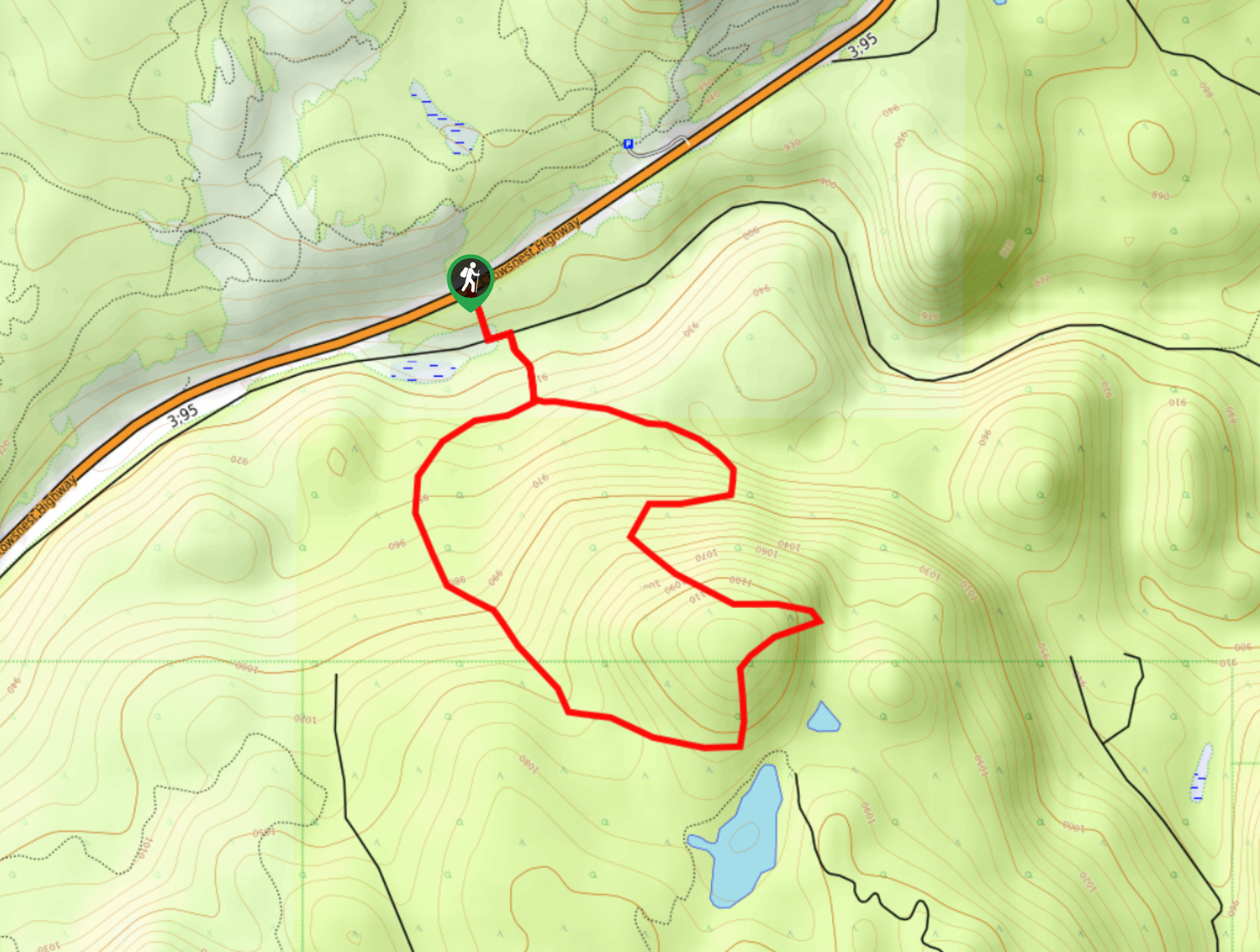
The Bee Line Trail is a 2.8mi lollipop hiking route in Cranbrook, BC, that will lead you uphill through a scenic stretch of forest to an amazingly scenic lookout. From the viewpoint atop the hill, you will have panoramic views of the landscape surrounding Cranbrook, including the Rocky Mountains to the east and the Purcell Mountains to the West. This is a very well-marked trail that is perfect for a fun family outing.
Getting there
To reach the parking area for the Bee Line Trail from Cranbrook, head north on BC-95/BC-3 for 4.4mi and you will find the trailhead on the right side of the highway along a rest stop/pullout.

About
| When to do | April-September |
| Backcountry Campsites | No |
| Pets allowed | Yes |
| Family friendly | Yes |
| Route Signage | Average |
| Crowd Levels | Moderate |
| Route Type | Lollipop |
Bee Line Trail
Elevation Graph
Weather
Bee Line Trail Description
Hiking the Bee Line Trail is a great way to get out and explore the natural beauty of the landscape surrounding the city of Cranbrook. Along this hike, you will make your way through a charming forest setting with ample signage and boardwalks that help you to reach the amazing lookout point at the top of the hill. The route isn’t very difficult, but it does feature a few steeper sections that should be manageable for hikers of most skill levels, including children. Make sure to bring microspikes if you are hiking in the shoulder seasons, as these steeper sections can become fairly icy.
The trail sets out from the side of the highway and immediately enters the forest. You will very quickly come to the Isadore Canyon Trail, at which point you should follow it to the left for roughly 100 paces. Here, you will find the main trail on your right that leads into the forest on a loop to the lookout. Make your way onto the boardwalk and follow the trail signs that will eventually take you up to an amazing hilltop perch with views of the Rocky and Purcell mountains. Feel free to take a bit of a rest while you enjoy the spectacular views before turning back and following the trail to the right to complete the loop. After descending through the serene forest atmosphere, you will arrive back at the junction with the Isadore Canyon Trail, where you can follow your initial route to return to the highway.
Similar hikes to the Bee Line Trail hike

Spirit Trail Loop
The Spirit Trail Loop is a 10.1mi hiking circuit in the East Side Columbia Lake Wildlife Management Area,…

Mount Stevens and Teepee Mountain
The trek to Mount Stevens and Teepee Mountain is a steep 8.4mi out-and-back hiking route east of Wasa,…

Ram Creek Hot Springs
Hiking to the Ram Creek Hot Springs will take you on an 6.9mi out-and-back trail that runs along…
Comments