
Blue Ridge Trail
View Photos
Blue Ridge Trail
Difficulty Rating:
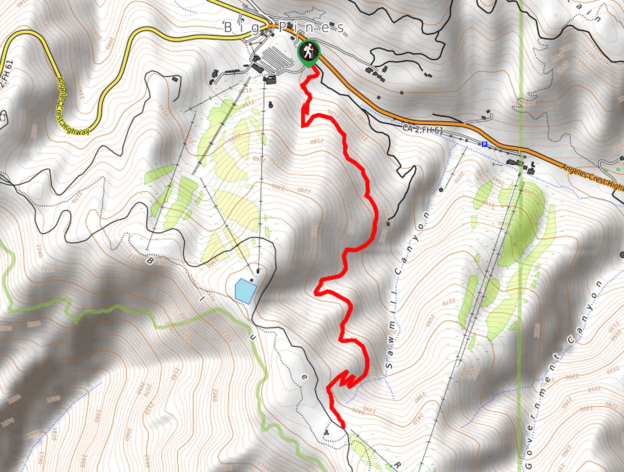
Hiking the Blue Ridge Trail is a great experience in Angeles National Forest that will take you uphill for gorgeous views of the mountainous California landscape. While out on the trail, you will work your way up through the forest to reach the top of a ridge, where you will enjoy sweeping views across the undulating landscape. Be cautious if hiking this route in cold/icy weather and make sure to bring microspikes and hiking poles for better traction.
Getting there
The starting point for the Blue Ridge Trail can be found along CA-2 at the Mountain High Resort.

About
| Backcountry Campground | Blue Ridge Camp |
| When to do | April-September |
| Pets allowed | Yes - On Leash |
| Family friendly | Yes |
| Route Signage | Average |
| Crowd Levels | High |
| Route Type | Out and back |
Blue Ridge Trail
Elevation Graph
Weather
Blue Ridge Trail Description
If you are after a moderately challenging adventure in the San Bernardino area that features some elevation gain, beautiful views, and is still suitable for the family, then you should absolutely take some time to explore the Blue Ridge Trail.
Setting out from the parking lot at the Mountain High Resort, you will pick up the trail leading to the south and into the tree cover. Here, you will almost immediately begin climbing uphill, gaining elevation and access to scenic views as you work your way to the top of the ridge.
Once there, you will enjoy spectacular views that spread out in all directions to include nearby mountains and hills. After taking in the beautiful views, simply head back downhill along the same route to return to your vehicle below.
Similar hikes to the Blue Ridge Trail hike

Mount Zion via Lower Winter Creek Trail Loop
The Mount Zion via Lower Winter Creek Trail Loop is a physically demanding Southern California adventure that features waterfall and…

Castaic Falls Trail
Hiking the Castaic Falls Trail is a fun little adventure in the Angeles National Forest that features a charming waterfall.…

Graveyard Truck Trail
Hiking the Graveyard Truck Trail is a pleasant experience in Southern California that features easy-going terrain and views of the…
Comments