Calf and Cautley Spout Walk
View Photos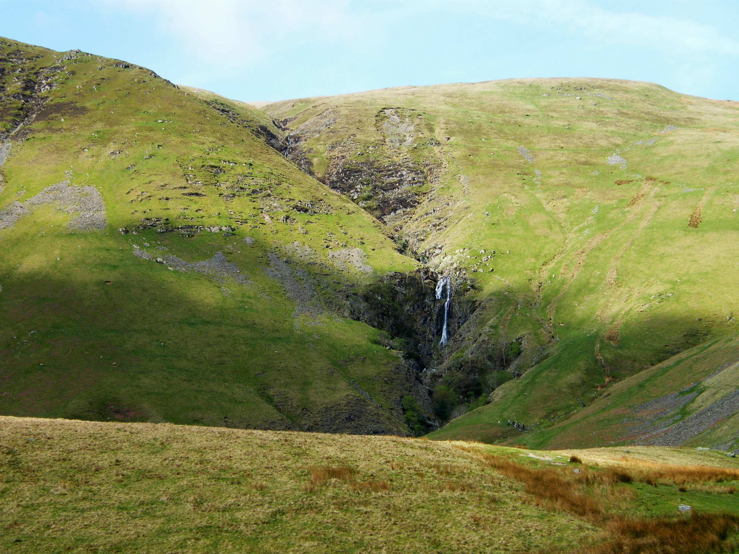
Calf and Cautley Spout Walk
Difficulty Rating:
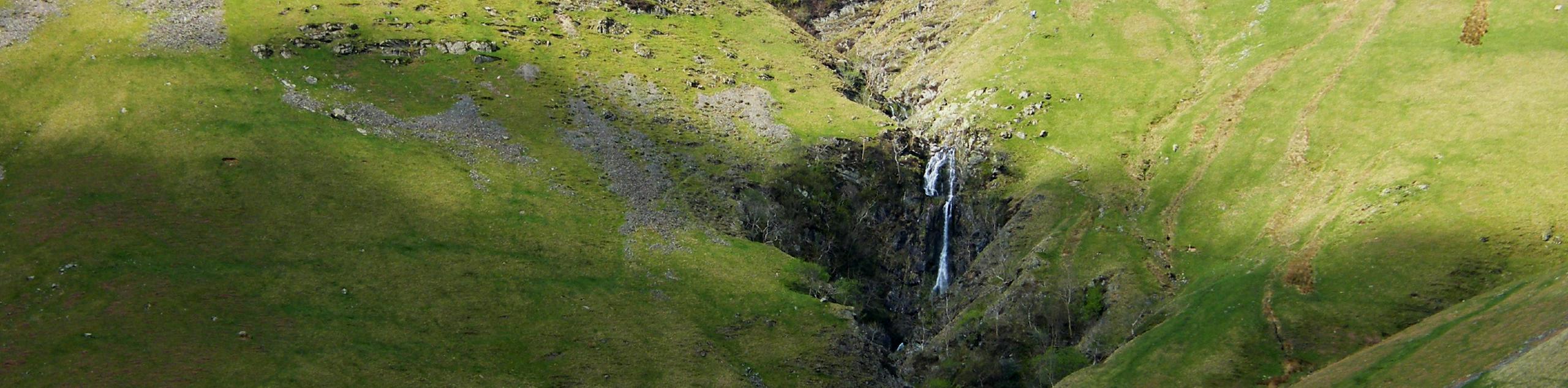
The Calf and Cautley Spout Walk takes you on a beautiful stroll to the highest waterfall in the United Kingdom, which sits at an impressive 650ft high and is nestled among beautiful rock formations. The views from the Cautley Home Beck will dazzle you as this area showcases both familiar English countryside views as well as a somewhat desert landscape.
Getting there
To get to the Calf and Cautley Spout Walk from Sedberg, head east on Main Street/A684 toward Joss Lane and turn left onto Long Lane/A684. Continue onto A683 and in 3.4mi, turn left. Make an immediate left, and in 0.4mi, you will arrive at your destination.

About
| Backcountry Campground | No |
| When to do | May - September |
| Pets allowed | Yes |
| Family friendly | No |
| Route Signage | Average |
| Crowd Levels | Moderate |
| Route Type | Out and back |
Calf and Cautley Spout Walk
Elevation Graph
Weather
Calf and Cautley Spout Walk Description
The Calf and Cautley Spout Walk takes you on a magical journey that displays familiar English countryside views and incorporates desert-like landscapes. This walk has steep uphill and downhill areas and is rated as a challenging walk, so experienced walkers should only attempt it.
The path has stunning views of the surrounding area, but you can expect rough terrain as you work towards the vistas. There is a lot of reward for the risk on this path as the scenery is like nothing else and goes on for miles into the distance.
Beginning at the roadside parking area near Cross Keys Public House, start along the footpath sign for “Cautley Spout” and cross the wooden footbridge that sits over River Rothay. You will come across a wooden swing gate, pass through this, and then hop on the gravel path to the left. You will see Pickering Gill, which runs from Great Dummocks, which is the route back to the Calf.
The track heads towards Pickering Gill and Cautley Holme Beck, but swings to the right, heads around Ben End, and then begins to make its ascent. You will have great views of Cautley Spout ahead of you and Cautley Crags. As you walk up the grassy path, you will pass a small plaque that explains the history of the area. As you continue, you will come to the base of the massive falls that pour from above. You will continue along the grassy slope after taking in the beauty of the falls and follow the human-made steps. Along the hillside, you can see amazing views of Cautley Holme Beck as it joins the River Rawthey, onto Baugh Fell.
You will reach the top of the falls and cross the path along the Red Gill Beck stream as it goes up the valley. Continue along the path through the valley and you will see the path from Bram Rigg and Calf meet. Head right here and follow the path to the triangulation point on the Calf. It is here that you will be able to see expansive views of Great Dun Fell, Mickle Fell, Wild Boar Fell, Pen-y-Ghent, and so many more amazing places in the Yorkshire Dales National Park.
Following the path, you will begin to head down where the path from Force Gill Beck meets the Bram Rigg Top to the Calf Path. Continue straight and you will reach Bram Rigg Top and move onto Calders. Moving along, continue straight across Great Dunmacks, and then head right, crossing the Great Dunmacks, and then follow the path to the top of Cautley Crags. Make sure you are careful at this point as this is rough terrain that drops off the cliff and visibility may not be good, depending on weather conditions. You will then begin heading downhill on a steep path to Pickering Gill. Take in the views of the three peaks and then continue heading down to the wall. You will then see a track by a barn, head down to this and follow to the left, passing a gate and a wooden footbridge that enters the outbound path. Turn right and follow this to the footbridge, and then to the roadside parking.
Insider Hints
Parts of this path have sheer drops, so ensure you are alert and have the appropriate footwear
Head to the Fairfield Mill to explore arts and crafts
Book a night at the Dalesman Country Inn
Grab food at the Three Hares Cafe
Similar hikes to the Calf and Cautley Spout Walk hike
Old Gang Smelt Mill and Reeth High Moor Walk
The Old Gang Smelt Mill and Reeth High Moor Walk is a rough and rugged adventure that will take you…
Hawes and Sedbusk Walk
The Hawes and Sedbusk Walk is a great family-friendly adventure in Yorkshire Dales National Park that will take you through…
Malham Tarn Upland Farm Walk
The Malham Tarn Upland Farm Walk is a fantastic route in Yorkshire Dales National Park that will take you around…
Comments