
Silas Lakes Trail
View Photos
Silas Lakes Trail
Difficulty Rating:
The Silas Lakes Trail is a wonderful adventure located at the southern end of the Wind River Mountain Range that boasts scenery and tranquility. Explore enchanting woodlands abundant with a variety of flora and fauna before culminating at a beautiful lake.
Getting there
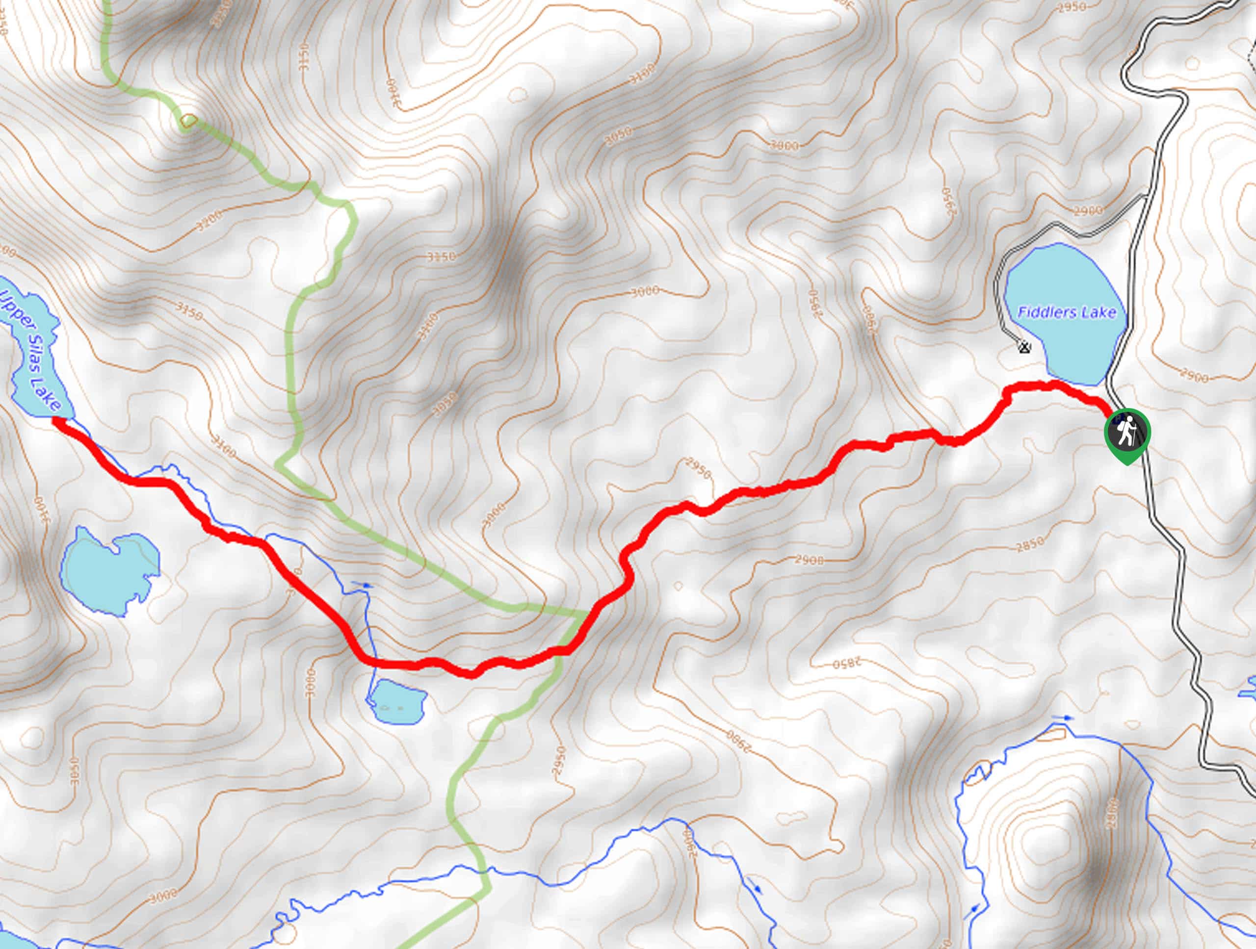
Access this hike from the Christina Lake Trailhead off Louis Lake Road.

About
| Backcountry Campground | Backcountry Camping |
| When to do | May-October |
| Pets allowed | Yes - On Leash |
| Family friendly | Yes |
| Route Signage | Average |
| Crowd Levels | Moderate |
| Route Type | Out and back |
Silas Lakes Trail
Elevation Graph
Weather
Silas Lakes Trail Description
The Silas Lakes Hike is a well-marked adventure that gradually undulates through dense woodlands and swathes of meadowlands to Silas Lake. Note sections of the path are rocky and uneven, so be mindful of your footing. As this path travels deep into the wilderness, it is important to be mindful of wildlife, including bears. Make sure at least one person in your party carries a can of bear spray—just in case.
Your adventure begins from the Christina Lake Trailhead. Setting out from here, you will wander along the southern shore of Fiddlers Lake before escaping beneath the treeline. As you climb, be sure to admire the mixed pines that line the forested corridor. After some hiking, you will confront an intersection, veer right here, and you will be diverted onto the Silas Lake Trail. Beyond this point, the terrain will become increasingly exposed and rocky—offering distant views of the Wind River Mountains.
Eventually, the path will pass Lower Silas Lake. From here, hikers will follow Silas Creek, traveling past Tomahawk Lake and up to Upper Silas Lake. Admire the alpine oasis that surrounds you and dip your tired feet in the chilly waters. When you are ready, simply retrace your footing along the path back to the trailhead.
Similar hikes to the Silas Lakes Trail hike
Glacier Trail
The Glacier Trail is a demanding day hike in the Winds that boasts a scenic and secluded experience. Wander through…
Upper Brewers Trail
The charm of a one-way trek is unrivaled. Enjoy new scenery every step of the way as you hike the…
Sheep Bridge Trail
The Sheep Bridge Trail checks all the boxes—short, scenic, and secluded. What more could you ask for? Mountain views? It…
Comments