Cirque of the Towers Overlook Hike
View Photos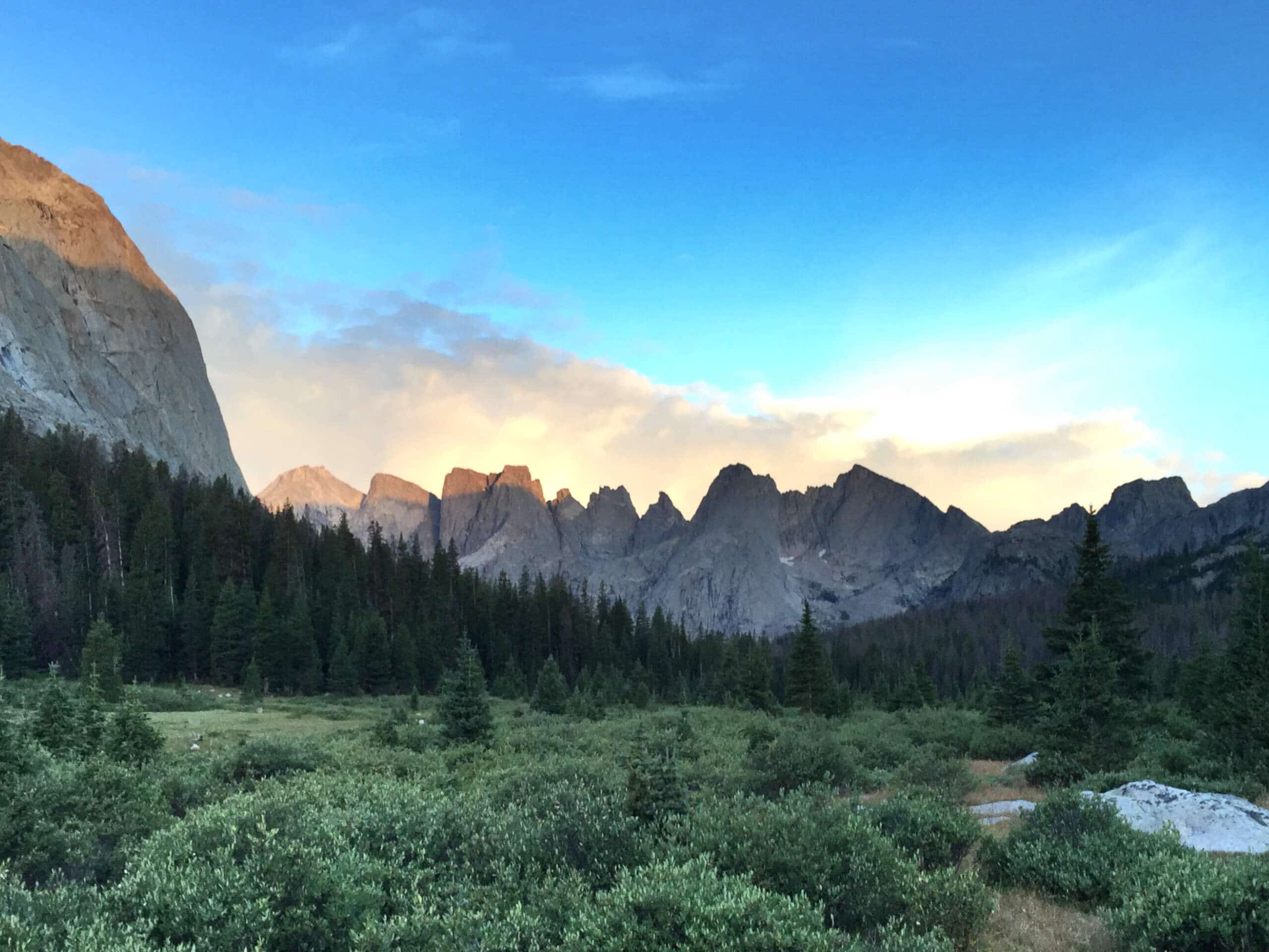
Cirque of the Towers Overlook Hike
Difficulty Rating:
Hike into the heart of the Wind River Mountains and indulge in spell-binding views on the Cirque of the Towers Overlook Hike. While demanding, this adventure to Jackass Pass boasts impressive views of the crags that will render you speechless.
Getting there
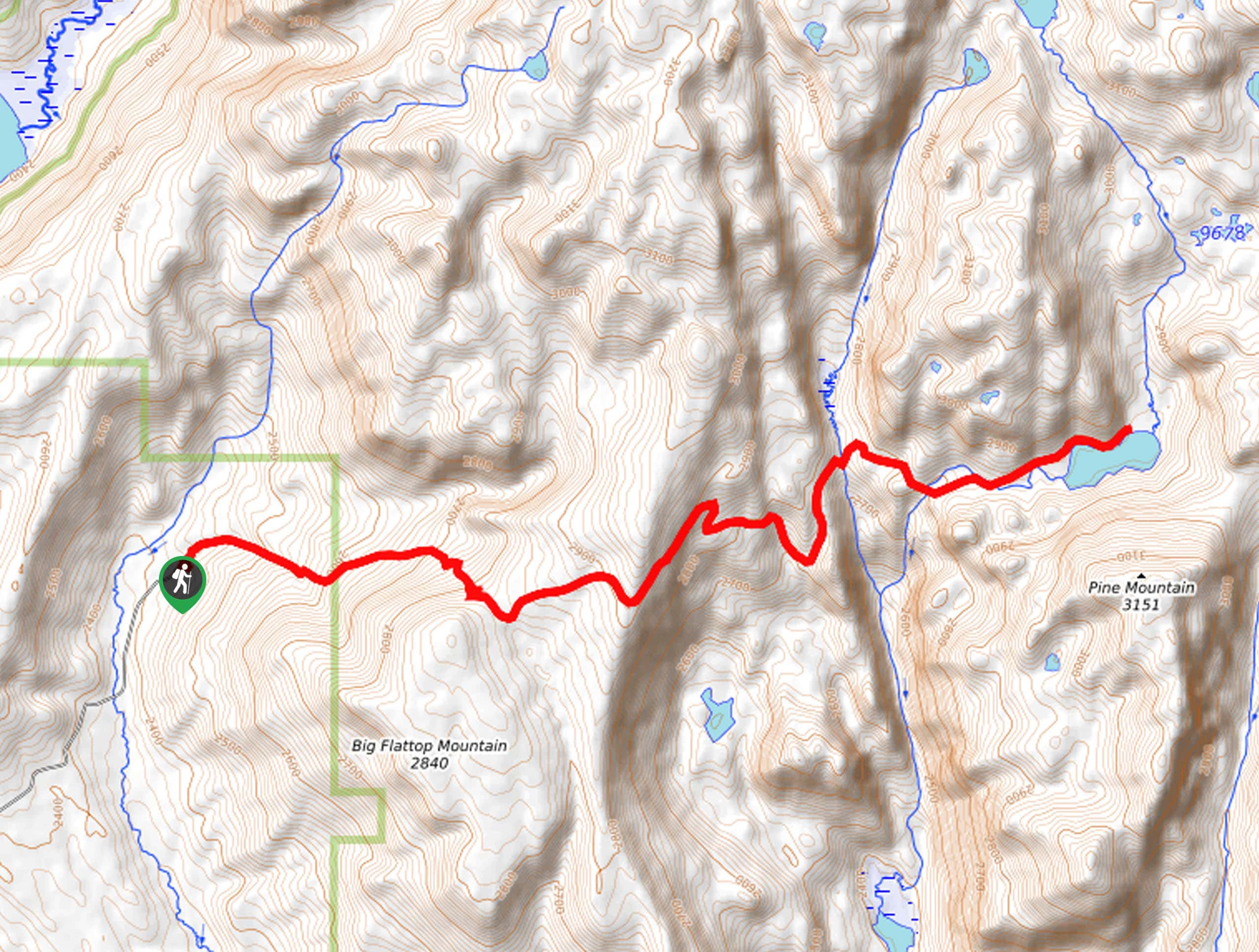
The Cirque of the Towers Overlook Hike departs from the Big Sandy Trailhead off Big Sandy Opening Road.

About
| Backcountry Campground | Backcountry Camping |
| When to do | May-October |
| Pets allowed | Yes - On Leash |
| Family friendly | No |
| Route Signage | Average |
| Crowd Levels | High |
| Route Type | Out and back |
Cirque of the Towers Overlook Hike
Elevation Graph
Weather
Cirque of the Towers Overlook Hike Description
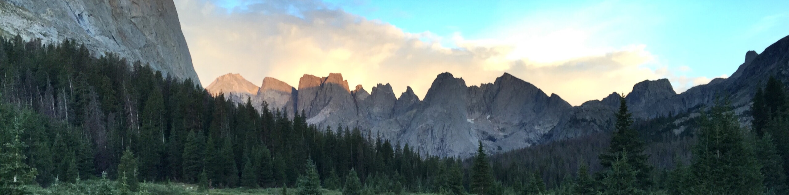
Beckoning the exploration of backpackers and intrepid day-hikers, the Cirque of the Towers Overlook Trail will undoubtedly test your limits. Traveling high into the mountain range over technical, unmarked terrain—this trek is no walk in the park. Make sure you are properly equipped with the downloaded trail GPS, a comfy pair of footwear, and bear spray! Additionally, as exposed terrain at high altitudes often sees extreme weather, we encourage you to dress in layers as insurance against changing conditions. Note this route is used as the gateway into the cirque and the Bridger Wilderness, so expect company!
The Cirque of the Towers Overlook Hike checks all the boxes—a good workout, great views, and dog-friendly—what more could you ask for? Before navigating the technical granite terrain, this route strolls through blossoming meadows, enchanting woodlands, and alongside a lazy river before opening into the alpine oasis carpeted with outcrops and vibrant tundra. Traveling through a diversity of landscapes, this hike also yields an abundance of flora and fauna, including deer, elk, bears, and marmots. Don’t forget to bring your camera, the views of the Cirque of the Towers are unrivaled.
Embark on your epic expedition into the Wind River Mountains from the Big Sandy Trailhead. Setting out from here, the Cirque of the Towers Overlook Hike follows the Freemont Trail alongside the Big Sandy River into the wilderness. This lovely access trail wanders through lodgepole forests and meadows to an intersection. Here, turn right before taking a sharp left onto the Big Sandy Lake Trail. Consistently climbing this segment of the path offers views of the crags rising above the landscape. Wandering along the lazy river, you will weave between swathes of luxuriant meadows and shaded tree stands.
After some trekking, the path will pass Diamond Lake. Beyond this point, the terrain will become increasingly rocky and uneven. Mind your footing as you climb and enjoy the views of Big Sandy Lake and Big Sandy infolding before your eyes. Soon you will reach the shoreline of Big Sandy Lake. Admire the beauty of the lake encircled by towering pines, the craggy ridges of Big Sandy Mountain, and vibrant patches of alpine tundra. Take the time here to rest and rehydrate before commencing your final push to the overlook. From this point forward, you will likely be in the company of climbers and backpackers heading past the overlook and into the cirque.
Continue hiking, intersecting with Lost Creek before diverting into the craggy canyon bisected by North Creek. Minding your steps as you navigate the vertiginous and rocky terrain, the route will guide you over North Creek and up to the shoreline of North Lake. Appreciate the beauty of the blue-hued pool and notice how the sights of Dog Tooth Peak and the War Bonnet towering above will make you feel small. Using the trail GPS or following the rock cairns, you will be led around the north shore of the lake, climbing up towards Arrowhead Lake—if you reach the lakeshore, you’ve gone too far.
Instead, you will climb further towards the cirque. From here, take the trail that climbs a foliage-covered ridge. Scramble up the rocky terrain just below Mitchell Peak to an epic overlook of the Cirque of the Towers. The spell-binding view is breathtaking. Marvel at the beauty and grandeur of the granite oasis and enjoy an up-close and personal view of the War Bonnet and Arrowhead Lake to the southwest. If you have time and energy, you can persist over the final ridge into the cirque. If these views are satisfactory enough, retrace your footing along the path back to the trailhead.
Trail Highlights
Cirque of the Towers
Located in the Wind River Range, the Cirque of the Towers is a collection of prominent peaks on the Continental Divide that tower above 12000ft, commanding the skyline. Lizard Head Peak is the highest of the mountains, but others include Shark’s Nose, War Bonnet Peak, Warrior Peak, Wolf’s Head, and Pingora Peak. The cirque is a popular destination for intrepid climbers and backpacking enthusiasts.
Frequently Asked Questions
How long is the Cirque of the Towers Overlook Hike.
The Cirque of the Towers Overlook is a 16.6mi out-and-back hike in Wind River.
How tall is Cirque of the Towers?
Cirque of the Towers looms above 12000ft in the Wind River Mountain Range.
Insider Hints
Bring the trail GPS, the tail end of the hike is only marked by cairns
Dress in layers, the higher you climb the windier will the conditions get
Make sure at least one person in your group carries bear spray
Wear a sturdy pair of footwear, much of the route is rocky and uneven
Be mindful of falling rocks as you hike amongst the crags
Similar hikes to the Cirque of the Towers Overlook Hike hike
Glacier Trail
The Glacier Trail is a demanding day hike in the Winds that boasts a scenic and secluded experience. Wander through…
Sweeney Creek Trail
The Sweeney Creek Trail can be enjoyed in a myriad of different ways. This epic expedition into the high country…
Section Corner Lake Trail
The Section Corner Lake Trail exemplifies the beauty and grandeur of the Wind River Mountain Range. Somewhat of a hidden…
Comments