
Cutthroat Lake Trail
View Photos
Cutthroat Lake Trail
Difficulty Rating:
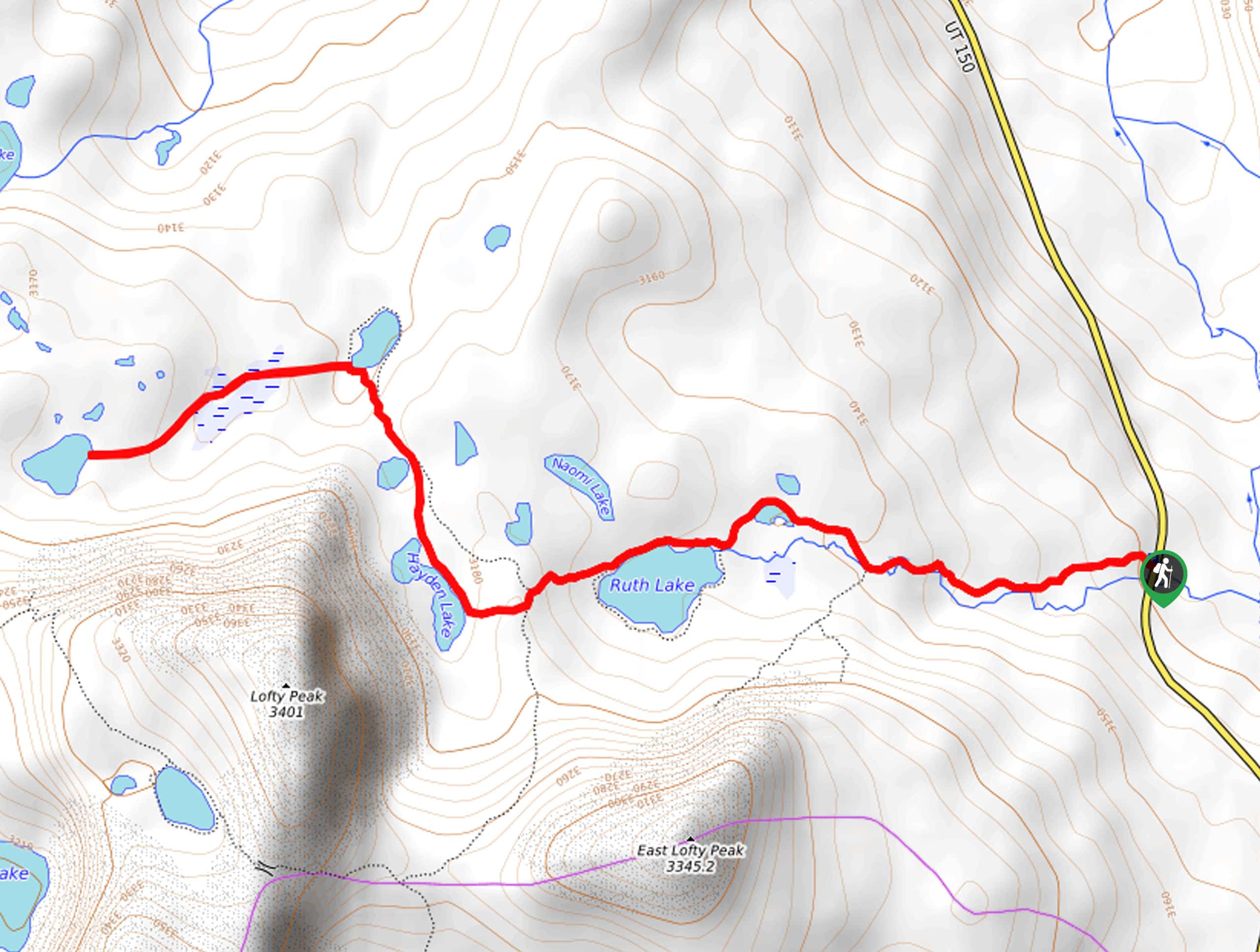
The Cutthroat Lake Trail is a beautiful hike east of Park City, Utah. This trail brings you past four stunning alpine lakes: Ruth Lake, Hayden Lake, Jewel Lake, and Cutthroat Lake. The Cutthroat Lake Trail makes an excellent day-hike or a fun and easy overnight backpacking trip.
Getting there
From Kamas, Utah, head east out of town on highway 150. Stay on Highway 150 for 34.0mi and look for the Ruth Lake parking area on the west side of the highway, just past the Butterfly Lake Campground. The Cutthroat Lake Trail begins here.

About
| Backcountry Campground | Primitive Camping at Ruth Lake, Jewel Lake, and Cutthroat Lake |
| When to do | April to October |
| Pets allowed | Yes |
| Family friendly | Older Children only |
| Route Signage | Poor |
| Crowd Levels | Moderate |
| Route Type | Out and back |
Cutthroat Lake Trail
Elevation Graph
Weather
Cutthroat Lake Trail Description
The Cutthroat Lake Trail is a gorgeous hike in the western Uintas. This trail is well maintained and well-traveled up to Ruth Lake. Once you pass Ruth Lake, the path becomes less defined, and some creative route finding is required. If you are not experienced in route finding, we recommend bringing along a map and/or GPS unit to help you stay on track. You will definitely want to bring a camera as well; the views along the Cutthroat Lake Trail are absolutely stunning.
Beginning at the Ruth Lake Trailhead, follow the well-marked path west as it winds along Hayden Fork to a divide. Stay right at the divide to make your way to Ruth Lake. Follow the path along the north shore of Ruth Lake and, just west of Ruth Lake, look for the rugged trail that branches off to your right. Follow this trail northwest for 0.4mi to Jewel Lake. From Jewel Lake, make your way west to the shores of Cutthroat Lake.
Kick back and relax at Cutthroat lake, and go for an invigorating swim in the cool waters before heading back to the trailhead following the way you came.
Similar hikes to the Cutthroat Lake Trail hike

Willard Creek Waterfall Trail
The Willard Creek Trail is an adventurous yet beautiful hike on the eastern edge of Willard, Utah. This trail is…

Skull Crack Trail
Despite the foreboding name, the Skull Crack Trail is a fantastic hike in the Uinta-Wasatch-Cache National Forest. This trail follows…

Box Elder Creek Trail
The Box Elder Creek Trail is a lovely hike northeast of Salt Lake City. This trail is used by both…
Comments