
Center Canyon Trail
View Photos
Center Canyon Trail
Difficulty Rating:
The Center Canyon Trail is a gorgeous hike in the Western Uintas. This trail is used by both hikers and OHV drivers but is rarely busy. A peaceful hike through the forest, the Center Canyon Trail is an excellent spot to see forest wildlife such as elk and deer.
Getting there
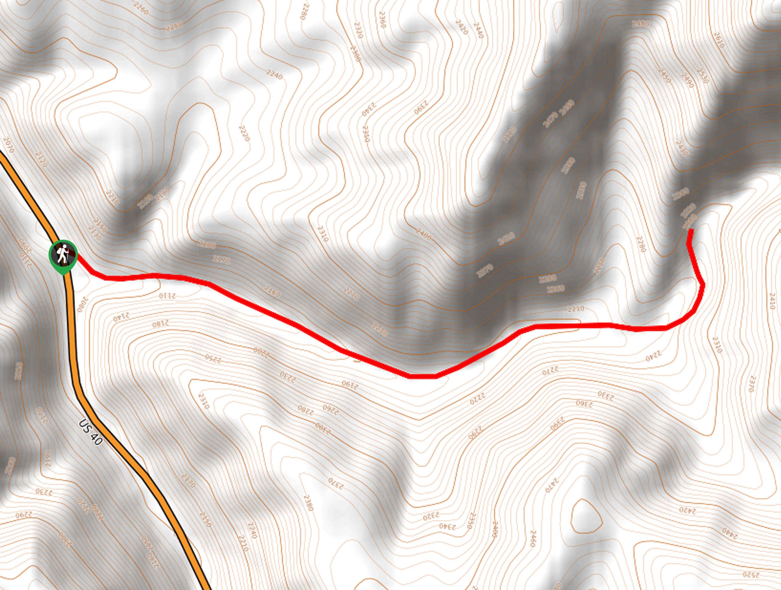
From Heber City, Utah head southeast along highway 40 for 10.0mi. Turn left onto Center Canyon Road and park along the road. The Center Canyon Trail begins here.

About
| Backcountry Campground | No |
| When to do | May to October |
| Pets allowed | Yes |
| Family friendly | Older Children only |
| Route Signage | Average |
| Crowd Levels | Low |
| Route Type | Out and back |
Center Canyon Trail
Elevation Graph
Weather
Center Canyon Trail Description
The Center Canyon Trail is a beautiful hike southeast of Heber City, Utah. Both hikers and OHV-drivers use this trail, so when hiking, be sure to stay aware of your surroundings and allow folks with wheels to pass you by. This trail is dog-friendly and is a great place to see forest wildlife. If your dog is reactive to other animals, be sure to keep them on a leash. If you are lucky enough to catch sight of wild animals such as deer or elk, who are often seen along this trail, do not feed them and give them plenty of personal space. With low-traffic year-round, the Center Canyon Trail is a great place to go for some peace and solitude in the beautiful Utah Wilderness.
From the highway 40 turn-off, head east along Center Canyon Road for 1.8mi before turning around and retracing your steps back to the vehicle.
If you are looking for a beautiful place to spend the night after your hike, check out the Lodge Pole Campground just down the road.
Similar hikes to the Center Canyon Trail hike

Willard Creek Waterfall Trail
The Willard Creek Trail is an adventurous yet beautiful hike on the eastern edge of Willard, Utah. This trail is…

Skull Crack Trail
Despite the foreboding name, the Skull Crack Trail is a fantastic hike in the Uinta-Wasatch-Cache National Forest. This trail follows…

Box Elder Creek Trail
The Box Elder Creek Trail is a lovely hike northeast of Salt Lake City. This trail is used by both…
Comments