
Mono Hot Springs Hike
View Photos
Mono Hot Springs Hike
Difficulty Rating:
There is nothing better than relaxing in a natural hot spring, aren’t we right? Especially when you are surrounded by stunning scenery! The Mono Hot Springs Hike is a wonderful walk through the campground to the San Joaquin River and thermal pools. If you need to relax, head out to the Mono Hot Springs.
Getting there
The Mono Hot Springs Hike departs from the Mono Hot Springs Resort off Kaiser Pass Road.

About
| Backcountry Campground | |
| When to do | Year-round |
| Pets allowed | Yes - On Leash |
| Family friendly | Yes |
| Route Signage | Good |
| Crowd Levels | Moderate |
| Route Type | Out and back |
Mono Hot Springs Hike
Elevation Graph
Weather
Mono Hot Springs Hike Description
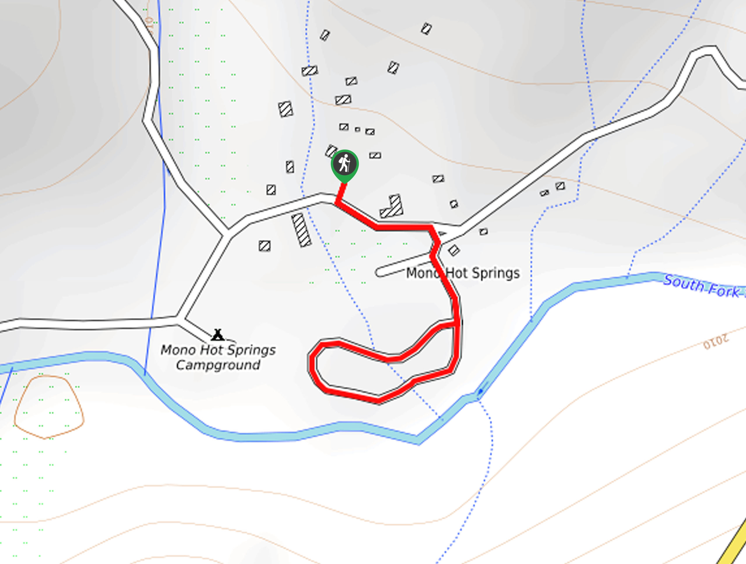
With six natural hot springs along the San Joaquin River, the Mono Hot Springs Hike is a must-add to your Sierra National Forest bucket list. Though coined the Mono Hot Springs Hike, this route is akin to an easy-going, quick nature walk. The encompassing scenery is picturesque, but the walk through the campground is not ideal, but the hot springs make up for the lack of wilderness along the route. Located near the campground and Mono Hot Springs Resort, the thermal pools are a popular spot, so we suggest heading out early to beat the crowds!
Perhaps you went on a technical trek yesterday, or you are simply yearning for a meditative experience, then head out along the Mono Hot Springs Hike. This wonderful route wanders through the bustling Mono Hot Springs Resort and Campground before reaching the thermal pools. Take a dip in the plunge pools or head down into the river for a more natural experience. Float in the hot pools bounded by granite bluffs and outcrops while reveling in the views of the lush vegetation that bound the river and the encompassing Sierra Nevada Mountains. We love a great hot spring, and if you do too, this trek is for you.
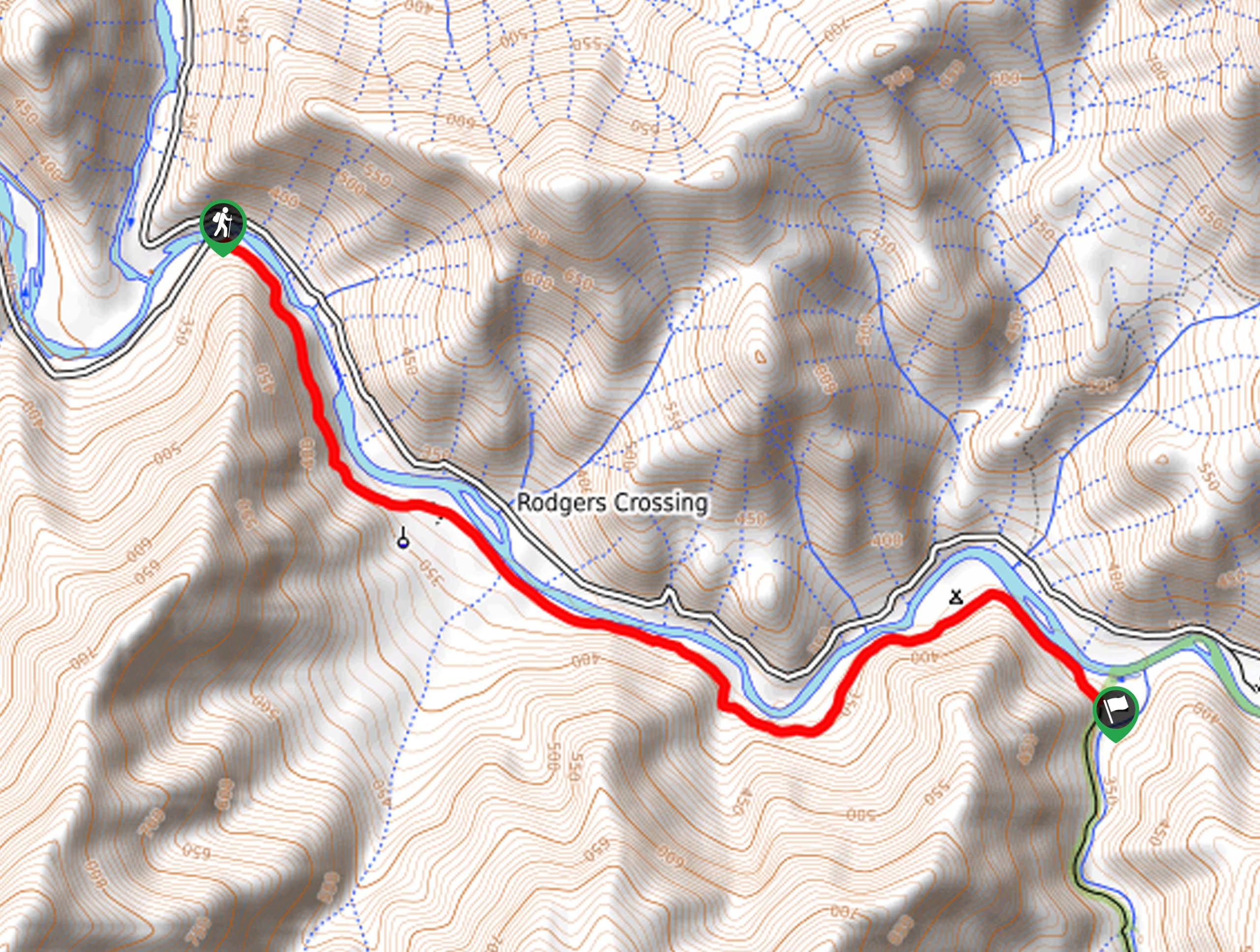
Setting out from the day-use parking lot in the Mono Hot Springs Resort, the Mono Hot Springs Hike heads south back to the road, where you will briefly head east, past the River Rock Café. At the route’s intersection, veer right, and you will be guided south into the US Forest Service Campground. Wander past the dozens of campsites towards the San Joaquin River. At this point, you will have you diverge from the road and trek down the bank to the hot springs. Take your time enjoying the warm mineral springs and stunning alpine views. When you are ready, loop through the campground, then retrace your footing along the road back to the parking lot, marking the end of your adventure.
Trail Highlights
Mono Hot Springs
The Mono Hot Springs is a set of six thermal pools on the San Joaquin River in the Sierra National Forest. Sitting at an elevation of 6562ft in the Sierra Nevada Mountain Range, the hottest the mineral springs get is around 112 °F. If you are seeking a nice relaxing soak amongst looming peaks and lush vegetation, then head out to the Mono Hot Springs.
Frequently Asked Questions
When are the Mono Hot Springs closed?
The Mono Hot Springs are never officially closed, but the Kaiser Pass Road is subject to seasonal closure—making them hard to access.
Are the Mono Hot Springs free?
Yes, you can access the Mono Hot Springs free of charge.
Insider Hints
Head out in the early morning to beat the crowds
Pack plenty of water to stay hydrated as you soak beneath the sun!
Note the Kaiser Pass Road is subject to seasonal closure
Charge your camera, the springs warrant plenty of photo opportunities
Don’t forget your swimsuit!
Similar hikes to the Mono Hot Springs Hike hike
Chiquito Pass Trail
The Chiquito Pass Trail is arguably one of the most scenic adventures in the Sierra National Forest. Wander up through…
Wuh-Ki'o Trail
The Wuh-Ki'o Trail is an unassumingly picturesque adventure in the Sierra National Forest. Traveling through meadowlands, brush, over bridges, and…
Davis Flat Trail
Experience the grandeur of the Sierra Nevada Mountains as you hike through the Kings River Valley, bounded by rolling hills.…
Comments