Manzanita and Azalea Trail
View Photos
Manzanita and Azalea Trail
Difficulty Rating:
The Manzanita and Azalea Trail is a charming adventure that is easily accessible from Wilsonia in the Kings Canyon National Park. Wander around the perimeter of the village amid the lush flora, including flowering Azalea and Manzanita.
Getting there
Begin this hike from the Grant Grove Visitor Center.

About
| Backcountry Campground | No |
| When to do | Year-round |
| Pets allowed | No |
| Family friendly | Yes |
| Route Signage | Average |
| Crowd Levels | Moderate |
| Route Type | Circuit |
Manzanita and Azalea Trail
Elevation Graph
Weather
Manzanita and Azalea Trail Description
This is a wonderful trail through lush forestlands adorned with carpets of verdant ferns and blooming wildflowers, exposing epic views of the Sierra Nevada Mountains along the way. Open year-round, this lovely path can be enjoyed with a pair of snowshoes and a pair of chained tires to access the Grant Grove Visitors Center. Be sure to stay on the marked path to safeguard the fragile environment. Note entrance to the park costs $35USD per vehicle or $20USD per person for pedestrians or cyclists.
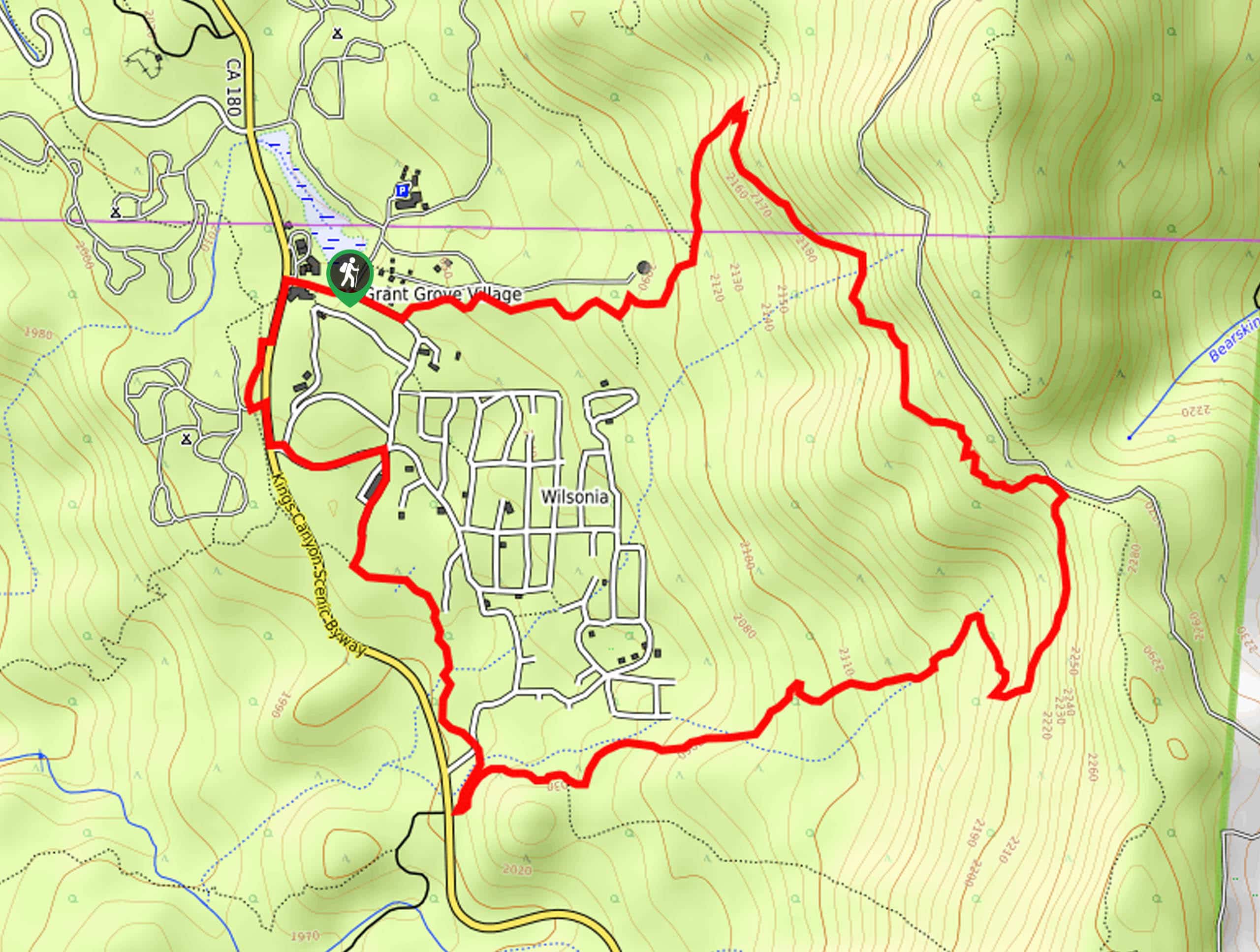
Embark on your adventure along the Manzanita and Azalea Trail from the Grant Grove Visitors Center. Setting out from here, head east along Upper Loop Road, turning left onto the Manzanita Trail at the trailhead. Follow this route into the lively wilderness. As you progress higher into the woodlands, you will be granted impressive views of the High Sierra, merging onto the Azalea Trail at the path’s end.
When you ultimately reach the trail’s end, turn right onto the South Boundary Trail. Eventually, you will want to turn right and cross over the Kings Canyon Scenic Byway and back to the Grant Grove Visitors Center.
Similar hikes to the Manzanita and Azalea Trail hike

Eagle and Bobcat Loop Hike
The Eagle and Bobcat Loop Hike is an amazing adventure that the whole family can enjoy. Wander through luxuriant meadows…
Bobcat Point Loop Hike
Seeking incredible vistas of the Sierra Nevada Mountain Range? The Bobcat Point Loop Hike is an incredible adventure in the…

Huckleberry and Alta Loop Hike
The Huckleberry and Alta Loop Hike is a beautiful adventure that offers a wealth of incredible scenery for hikers to…
Comments