
Wapato Lake Trail
View Photos
Wapato Lake Trail
Difficulty Rating:
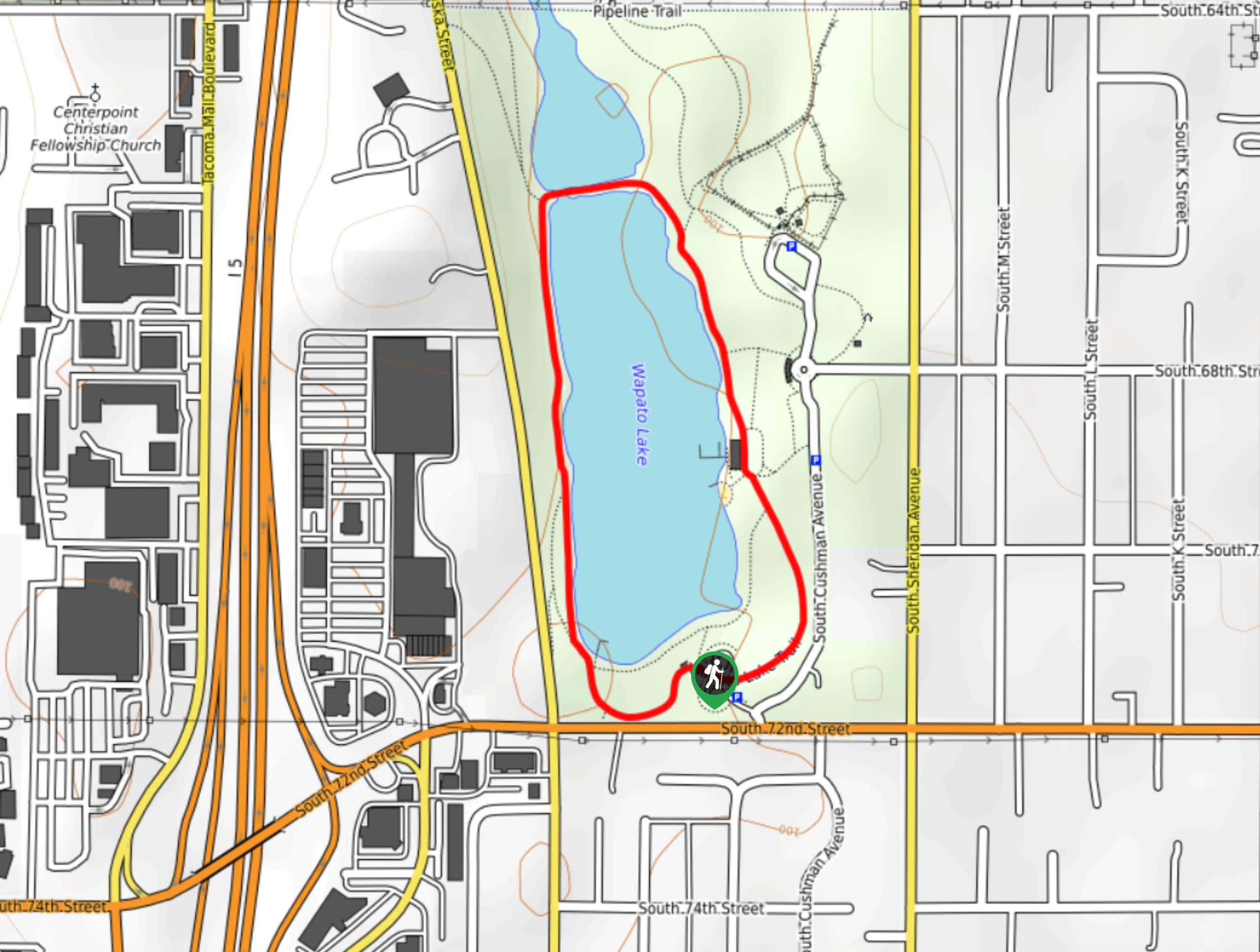
Wapato Lake Trail is a 1.0mi easy hike in Wapato Lake Park that is suitable for all skill levels. This hike circles Wapato Lake, providing access to a picnic area and dog park on the way. This trail is very easy to follow and a great choice for dog walkers who want to take advantage of the park.
Once you’re done hiking, check out the pretty gardens and snap a photo in the gorgeous historic pergola.
Getting there
The trailhead for the Wapato Lake Trail is at the south end of Wapato Lake off the loop road.

About
| Backcountry Campground | No |
| When to do | Year-round |
| Pets allowed | Yes - On Leash |
| Family friendly | Yes |
| Route Signage | Average |
| Crowd Levels | Moderate |
| Route Type | Loop |
Wapato Lake Trail
Elevation Graph
Weather
Wapato Lake Trail Description
Wapato Lake Trail is a very short, very easy loop walk around Wapato Lake. The walk is less than a mile long and essentially flat, making it suitable for every skill level. This walk might not seem like much on its own, but the surrounding park offers lots more to keep you busy after the trail.
Check out the beautiful gardens and the gorgeous historic pergola, which was built in 1938. The flowers bloom all year long! Or maybe plan a picnic and make use of the shelters, which are reservable if needed. There is also a dog park on the grounds for those with furry friends in tow.
There are restrooms at several points in the park and around the lake, including near the trailhead.
Begin from the south end of the lake. Take the trail on your left to begin walking around the east side of the lake. You’ll be between the water and S Alaska Street.
The trail reaches a junction at the crossing between the two bodies of water. Turn right here and then head south down the other side of the lake. Pass the dog park on your left, the parking area, and the main picnic area.
There are several intersecting trails here, but just keep going straight on your current path. You’ll walk past the bathhouse on your right and then reach a junction. Go left here to wrap around the wider side of the loop. Alternatively, you can go right to hug the shore and then take a very short connecting trail up to where you started.
If you want to make a longer trip out of it, you can go left at the junction where you’ll cross between the two sides of the water. This connects to a trail right on the northern border of the park. You can take any of the three intersecting trails on your right to head back down to the lake past the dog parks.
After you’re done, head into the main park to enjoy the afternoon or continue on to your next adventure.
Trail Highlights
Wapato Park
Wapato Park is an urban oasis near Tacoma set around a bright blue lake. The park is designed with an afternoon of fun in mind, offering plenty of activities to enjoy: boat launches for fishing, biking and hiking trails, dog parks, games, playgrounds, picnic areas, and gardens are all here for your use. Check out the historic pergola in the annual gardens, which was built in 1938.
Frequently Asked Questions
Can you swim in Wapato Lake?
No. You can boat in the lake, but it’s not open for swimming.
Do I need a pass or permit for Wapato Lake Trail?
No, no pass or permit is required to use this trail or visit the park.
Can you fish in Wapato Lake?
Wapato Lake is open for juvenile (under 15 years of age) fishing. It is stocked with rainbow trout.
Insider Hints
You can play horseshoes at the beach park.
Check out the gardens in different seasons to appreciate the different blooms.
Similar hikes to the Wapato Lake Trail hike

Sky Country to Harvey Manning Loop
The Sky Country to Harvey Manning Loop is a 4.2mi loop trail in the northern part of Cougar…

Iverson Spit Preserve Loop
The Iverson Spit Preserve Loop is a 1.2mi loop hike right on the beach, coursing through a beaver…

Lowell Riverfront Trail
The Lowell Riverfront Trail is a 3.0mi route alongside the Snohomish River in Everett. This trail is heavily…
Comments