
Sword Fern and Highline Trail
View Photos
Sword Fern and Highline Trail
Difficulty Rating:
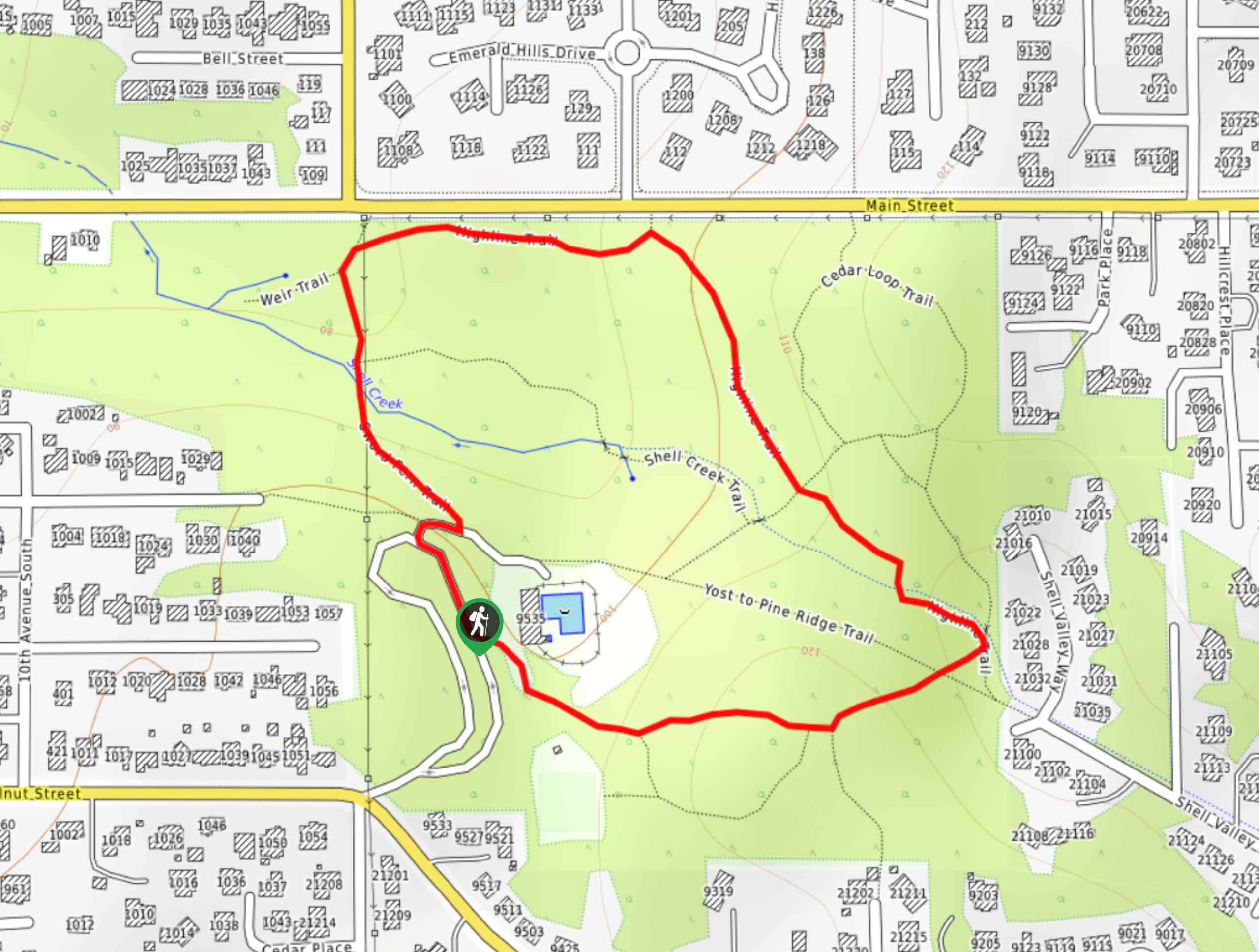
Sword Fern and Highline Trail is a super quick and extremely easy loop trail in Yost Park in Edmonds. It’s a go-to for locals to get some fresh air and it can be completed several times to get more distance in if you prefer a longer walk. There are intersecting trails in the park that may be confusing, so download your GPS if it’s the first time you’ve visited.
Getting there
The trailhead for the Sword Fern and Highline Trail is in the park off Bowdon Way.

About
| Backcountry Campground | No |
| When to do | Year-round |
| Pets allowed | Yes - On Leash |
| Family friendly | Yes |
| Route Signage | Poor |
| Crowd Levels | Moderate |
| Route Type | Loop |
Sword Fern and Highline Trail
Elevation Graph
Weather
Sword Fern and Highline Trail Description
The Sword Fern and Highline Trail is a pleasant short loop through the woods of an urban park. If it’s too short for you, you can use some of the connecting trails to lengthen your trip. The Yost Pool is in the park if you fancy a swim after.
Begin from the entrance to the park. You can do the loop either clockwise or counterclockwise. Follow the Sword Fern Trail and Highline Trail. If you accidentally find yourself on the Shell Creek Trail, Cedar Loop Trail, or Yost to Pine Ridge Trail, no worries, they’ll connect you back to the loop in no time. Enjoy the scenery before completing your loop back at the parking area.
Similar hikes to the Sword Fern and Highline Trail hike

Sky Country to Harvey Manning Loop
The Sky Country to Harvey Manning Loop is a 4.2mi loop trail in the northern part of Cougar…

Iverson Spit Preserve Loop
The Iverson Spit Preserve Loop is a 1.2mi loop hike right on the beach, coursing through a beaver…

Lowell Riverfront Trail
The Lowell Riverfront Trail is a 3.0mi route alongside the Snohomish River in Everett. This trail is heavily…
Comments