
Paradise Valley Conservation Area Trail
View Photos
Paradise Valley Conservation Area Trail
Difficulty Rating:
The Paradise Valley Conservation Area Trail is a 4.6mi easy hike on a pleasant wooded trail. This route is shared by hikers and cyclists. This trail is well-maintained and shaded most of the way. There are plenty of trails in the park that allow you to further explore if you wish. Watch out for exposed roots and cut trees.
Getting there
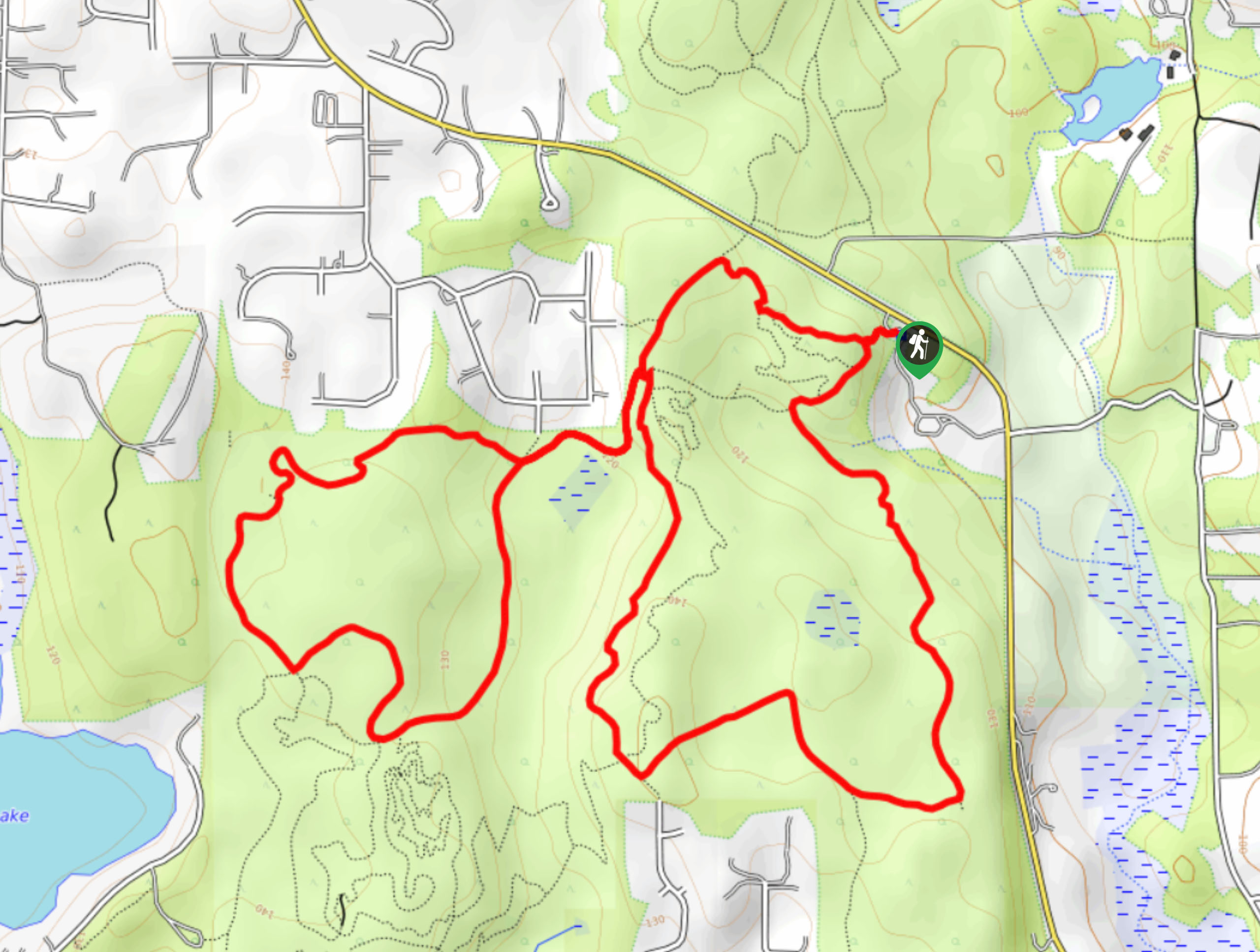
The trailhead for the Paradise Valley Conservation Area Trail is off Paradise Lake Road in the middle of the park.

About
| Backcountry Campground | No |
| When to do | Year-round |
| Pets allowed | Yes - On Leash |
| Family friendly | Yes |
| Route Signage | Average |
| Crowd Levels | High |
| Route Type | Loop |
Paradise Valley Conservation Area Trail
Elevation Graph
Weather
Paradise Valley Conservation Area Trail Description
The Paradise Valley Conservation Area Trail is a pretty route flanked by trees and ferns that offers a taste of nature to hikers of all skill levels. This route is shared by bikers and has some exposed roots, so keep an eye out as you go. There are lots of interconnecting trails in the park, so download your GPS ahead of time to stay on track.
Begin from the trailhead, heading to the split. You can go either way, but we’ll describe the route clockwise. Keep left at the split onto Mainline Trail and then left again onto Wetland Plateau Trail. Go straight through two junctions and then take a sharp left onto Mainline Trail. Keep left to stay on this trail and then take a right onto Red Alder Trail. Stay on this trail until 106 Dr Trail, where you’ll connect to Cascara Trail, which takes you back to where you started via Whispering Firs Trail.
Similar hikes to the Paradise Valley Conservation Area Trail hike

Explorer Falls Hike
The Explorer Falls hike is a 5.3mi moderate hike near Sultan, Washington. This trail takes you to a…

Sky Country to Harvey Manning Loop
The Sky Country to Harvey Manning Loop is a 4.2mi loop trail in the northern part of Cougar…

Iverson Spit Preserve Loop
The Iverson Spit Preserve Loop is a 1.2mi loop hike right on the beach, coursing through a beaver…
Comments