North Creek Trail: U of WA Bothell to Thrasher’s Corner
View Photos
North Creek Trail: U of WA Bothell to Thrasher’s Corner
Difficulty Rating:
This section of the North Creek Trail goes from the University of WA Bothell to Thrasher’s Corner, stretching 9.2mi. The route is very easy and mostly flat, comprised mostly of sidewalks. This is a good trail to take the dogs out on or to run if you live in the area. You can continue further on the North Creek Trail for more distance if desired.
Getting there
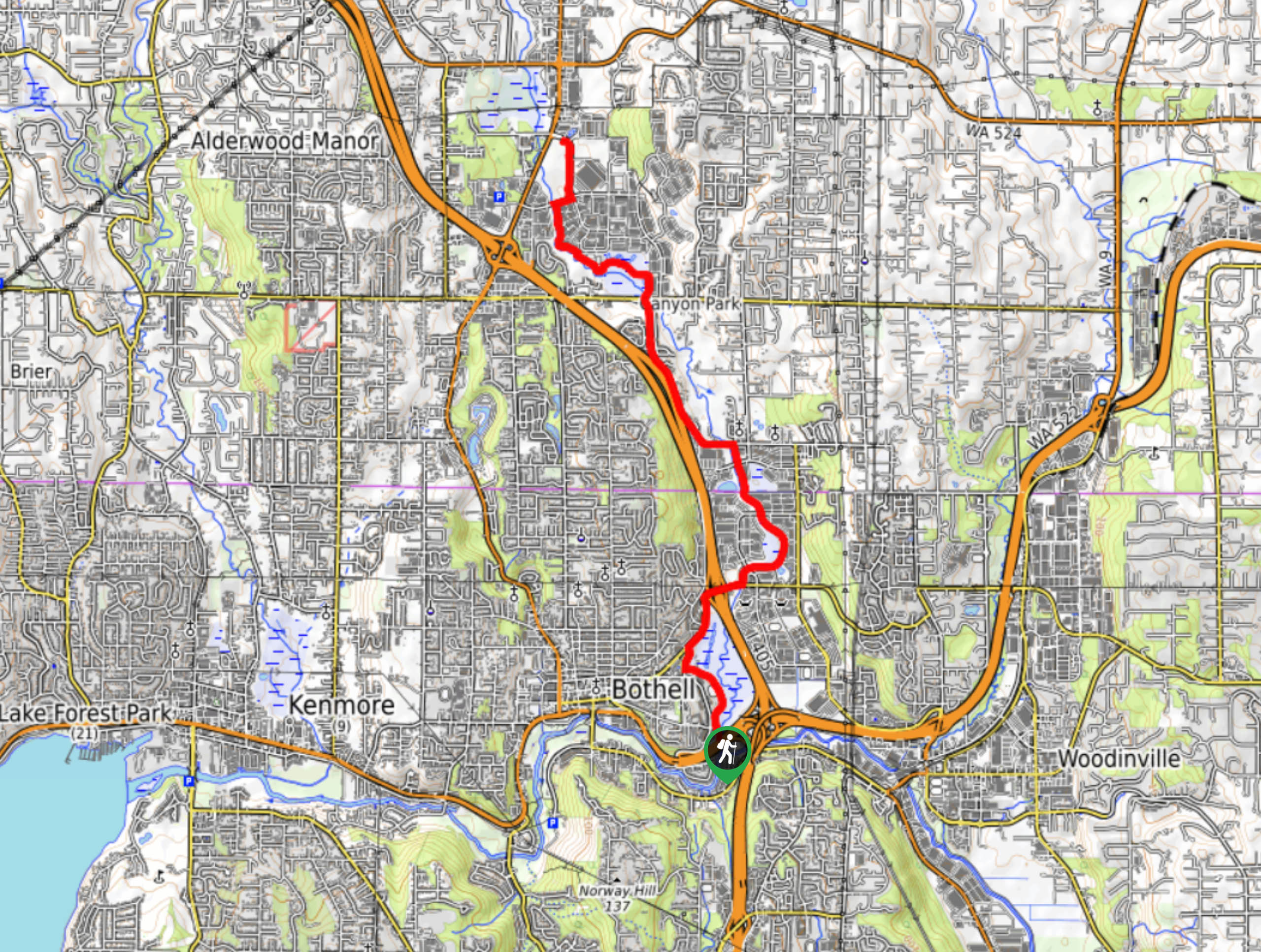
The trailhead for this section of the North Creek Trail is beside Chase House off S Campus Way.

About
| Backcountry Campground | No |
| When to do | Year-round |
| Pets allowed | Yes - On Leash |
| Family friendly | Yes |
| Route Signage | Average |
| Crowd Levels | Low |
| Route Type | Out and back |
North Creek Trail: U of WA Bothell to Thrasher’s Corner
Elevation Graph
Weather
North Creek Trail: U of WA Bothell to Thrasher’s Corner Description
North Creek Trail is a well-kept multi-use trail that links Bothell, Mill Creek, and Everett. The route is designed to link the Sammamish River Trail and the Burke Gilman Trail, so you can continue past the bounds of this guide for a longer adventure if you’d like. The route is mostly sidewalk. It’s not a trail with impressive views, but it’s perfect for exercising.
This stretch of the North Creek Trail begins off S Campus Way. Get on the trail and hike north past the field. The trail then followers the road, crossing the highway and then hugging the river as you cross N Creek Parkway. Take a left at 240th St SE and follow this until the trail then follows the creek.
This section terminates at the intersection of Bothell-Everett Highway and 214th St SE. Turn around here and retrace your steps or cross the street and turn right to continue further.
Similar hikes to the North Creek Trail: U of WA Bothell to Thrasher’s Corner hike

Explorer Falls Hike
The Explorer Falls hike is a 5.3mi moderate hike near Sultan, Washington. This trail takes you to a…

Sky Country to Harvey Manning Loop
The Sky Country to Harvey Manning Loop is a 4.2mi loop trail in the northern part of Cougar…

Iverson Spit Preserve Loop
The Iverson Spit Preserve Loop is a 1.2mi loop hike right on the beach, coursing through a beaver…
Comments