
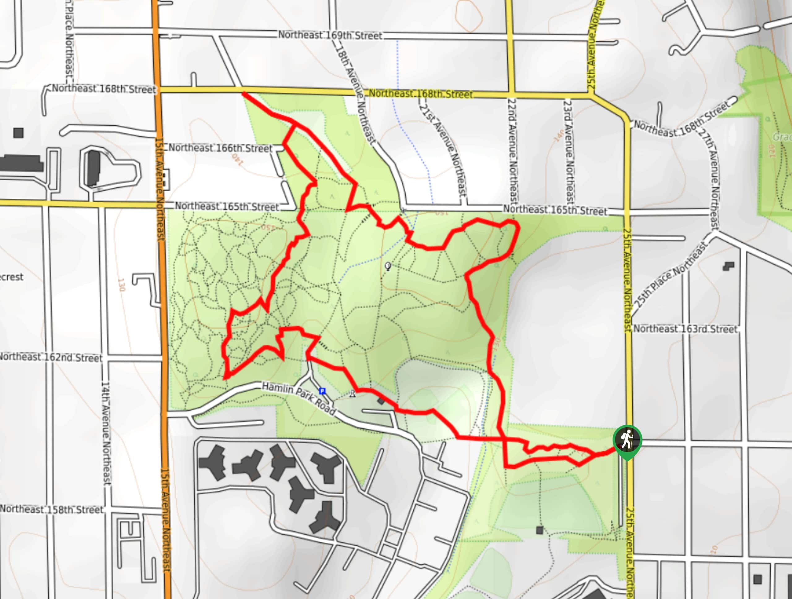
Hamlin Park Loop
View Photos
Hamlin Park Loop
Difficulty Rating:
The Hamlin Park Loop is a 2.0mi trail that follows the perimeter of Hamlin Park. This trail is very easy and mostly flat, but there are many intersecting trails that can make navigation difficult. We recommend downloading a GPS track. Additionally, this park gets most of its traffic after the workday, so visit in the morning or midday for a quieter experience.
Getting there
The trailhead for the Hamlin Park Loop is just south of Kellogg Middle school off 25th Ave NE.

About
| Backcountry Campground | No |
| When to do | Year-round |
| Pets allowed | Yes - On Leash |
| Family friendly | Yes |
| Route Signage | Poor |
| Crowd Levels | Low |
| Route Type | Loop |
Hamlin Park Loop
Elevation Graph
Weather
Hamlin Park Loop Description
Hamlin Park is a wonderful spot, with tall trees and a wooded network of trails accessible without leaving the city. This loop trail is a great way to explore the whole park, but it can get confusing with many unsigned junctions. Download the GPS ahead of time and when in doubt, just stick to the perimeter of the park.
Begin from the trailhead, which is next to the school. You’ll pass a field, some parking, and a restroom and play area as you walk. As you get into the thick of the trail network, just keep trying to work your way roughly northeast.
The route pops up into the far northern corner of the park and back down, winding behind the school and back to where you began. To extend your adventure, try exploring more of the trails in the interior of the park.
Similar hikes to the Hamlin Park Loop hike

Sky Country to Harvey Manning Loop
The Sky Country to Harvey Manning Loop is a 4.2mi loop trail in the northern part of Cougar…

Iverson Spit Preserve Loop
The Iverson Spit Preserve Loop is a 1.2mi loop hike right on the beach, coursing through a beaver…

Lowell Riverfront Trail
The Lowell Riverfront Trail is a 3.0mi route alongside the Snohomish River in Everett. This trail is heavily…
Comments