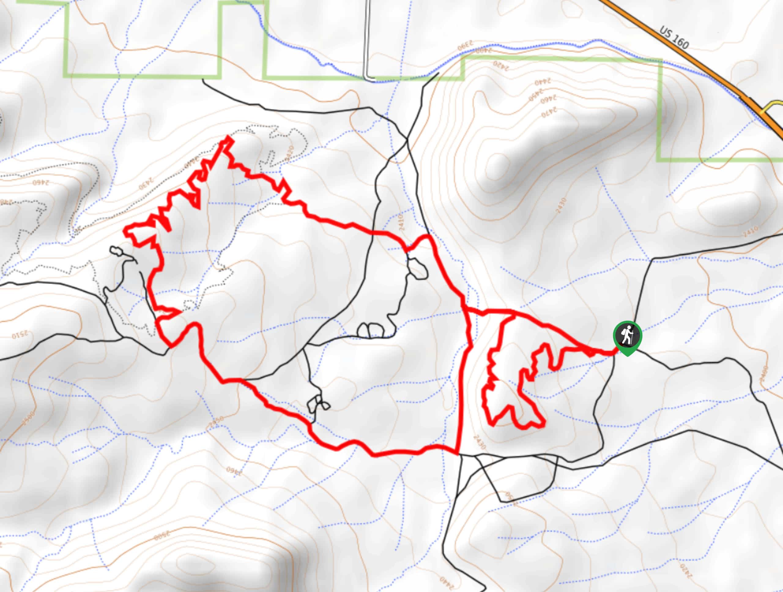
Stone Quarry Loop Hike
View Photos
Stone Quarry Loop Hike
Difficulty Rating:
The Stone Quarry Loop Hike is a rugged excursion southeast of Del Norte, Colorado that will take you through a desert like landscape with some light tree cover. While out hiking the trail, you will work your way through undulating hills while taking in the pleasant views of the surrounding landscape. Hikers should take note that this route is popular with mountain bike enthusiasts, so make sure to share the path and allow others to safely pass.
Getting there
The trailhead for the Stone Quarry Loop Hike can be found along US-160, just 4.9mi southeast of Del Norte.

About
| Backcountry Campground | No |
| When to do | Year-Round |
| Pets allowed | Yes - On Leash |
| Family friendly | Yes |
| Route Signage | Average |
| Crowd Levels | Moderate |
| Route Type | Circuit |
Stone Quarry Loop Hike
Elevation Graph
Weather
Stone Quarry Loop Hike Description
If you are looking to get outside for a bit of exercise and experience the natural beauty of the Colorado landscape, the Stone Quarry Loop Hike is a great option that is easily accessible and will provide a few hours of outdoor fun.
Setting out from the trailhead, you will make your way to the northwest across the undulating landscape, taking in the views of the surrounding area as you pass through some areas filled with scrub and light tree cover. As you loop around the trail, you will pass by several quarries and follow the trail as it bends back to the east. Here, you will once again make your way through the hilly landscape, before arriving back at the trailhead where you began.
Similar hikes to the Stone Quarry Loop Hike hike

Twin Buttes and Lightner Creek Loop Trail
The Twin Buttes and Lightner Creek Loop Trail is a great hiking route in Durango, Colorado that features some challenging…

Meadow Loop via Horse Gulch Trail
The Meadow Loop via Horse Gulch Trail is a great hiking route in Durango that will take you uphill for…

The Ridge Trail
The Ridge Trail - also known as Raiders Ridge Trail - is an amazing hiking route in Durango, Colorado that…
Comments