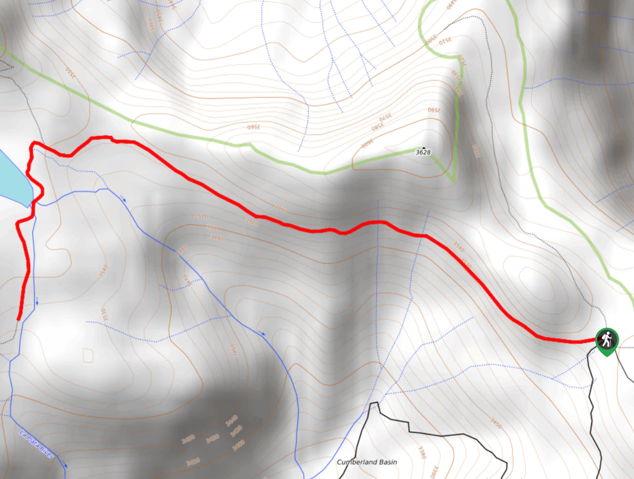
Highline Trail to Taylor Lake
View Photos
Highline Trail to Taylor Lake
Difficulty Rating:
Hiking the Highline Trail to Taylor Lake is a spectacular adventure in the San Juan Mountains of Colorado that will lead you to a charming lake. While out on the trail, you will make your way through a beautifully scenic meadow with gorgeous views of the surrounding alpine landscape, before arriving at the peaceful shores of Taylor Lake. Hikers should take note that the road leading into the trailhead is rough and rugged, requiring a 4x4 high clearance vehicle to safely traverse.
Getting there
The starting point for the Highline Trail to Taylor Lake can be found at the Kennebec Trailhead on County Road 124.

About
| Backcountry Campground | No |
| When to do | March-October |
| Pets allowed | Not allowed June 1-Sept15 |
| Family friendly | Yes |
| Route Signage | Average |
| Crowd Levels | Moderate |
| Route Type | Out and back |
Highline Trail to Taylor Lake
Elevation Graph
Weather
Highline Trail to Taylor Lake Description
If you don’t mind taking a bit of a drive to reach the trailhead of an ultra-scenic hike that ends at a lovely alpine lake, then the Highline Trail to Taylor Lake will be the perfect route for you to explore the stunning landscape of the San Juan Mountains.
Setting out from the trailhead, you will make your way to the northwest along an easy-going footpath that leads through a scenic alpine meadow. Here, you will be inundated with beautiful views of the surrounding forests and fields that are covered with wildflowers during the summer months. Eventually, you will arrive at the quiet shores of Taylor Lake, where you can sit and enjoy the mountain views while relaxing amongst nature. After spending some time by the lake, simply head back along the same path to return to the trailhead for the rugged ride back home.
Similar hikes to the Highline Trail to Taylor Lake hike

Twin Buttes and Lightner Creek Loop Trail
The Twin Buttes and Lightner Creek Loop Trail is a great hiking route in Durango, Colorado that features some challenging…

Meadow Loop via Horse Gulch Trail
The Meadow Loop via Horse Gulch Trail is a great hiking route in Durango that will take you uphill for…
Skyline Trail from Jenkins Ranch Road
Hiking the Skyline Trail from Jenkins Ranch Road is a great outdoor experience in Durango, Colorado that offers scenic views…
Comments