
Haviland Lake Trail
View Photos
Haviland Lake Trail
Difficulty Rating:
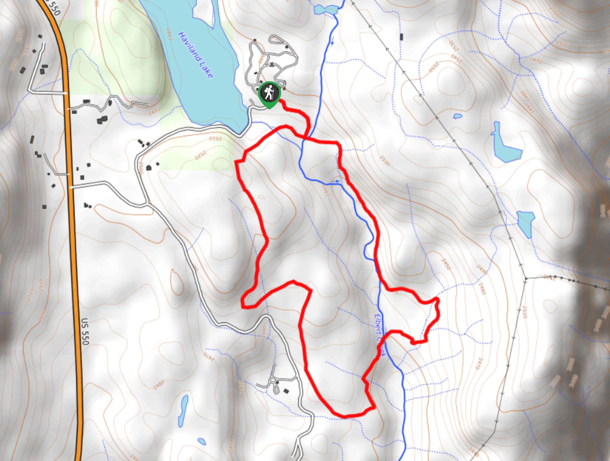
The Haviland Lake Trail is a laidback adventure in the San Juan Mountains that will take you along the forested hillside for views of the surrounding mountains. While out on the trail, you will leave the shores of Haviland Lake behind and enter into the forest, climbing uphill for views of the surrounding landscape, before looping around the woodland terrain on the return leg. Hikers should take note that the route along this trail is not very well marked, so make sure to bring a GPS if you want to ensure that you stay on the right track.
Getting there
The Haviland Lake Trailhead can be found at the Haviland Lake Campground on Haviland Lake Road.

About
| Backcountry Campground | Haviland Lake Campground |
| When to do | May-September |
| Pets allowed | Yes - On Leash |
| Family friendly | Yes |
| Route Signage | Average |
| Crowd Levels | High |
| Route Type | Lollipop |
Haviland Lake Trail
Elevation Graph
Weather
Haviland Lake Trail Description
If you are looking for an easy-going adventure in the San Juan Mountains of Colorado that will allow you to explore the forest, take in views of the surrounding landscape, and camp nearby to the trailhead, then the Haviland Lake Trail is a great option to do so.
Setting out from the trailhead, you will enter into the cover of the forest and head to the southwest until you arrive at a junction near the banks of Elbert Creek. Head right here and follow the path as it continues on to the southwest and climbs up the wooded hillside for beautiful views of the surrounding landscape and nearby mountains.
After meandering along the hillside, you will make a descent through the forest to the south, following the trail as it bends to the northeast and crosses back over Elbert Creek. Here, you will follow along the banks of the creek to the north, enjoying the last of the tranquil woodland atmosphere before arriving back at the trailhead.
Similar hikes to the Haviland Lake Trail hike

Twin Buttes and Lightner Creek Loop Trail
The Twin Buttes and Lightner Creek Loop Trail is a great hiking route in Durango, Colorado that features some challenging…

Meadow Loop via Horse Gulch Trail
The Meadow Loop via Horse Gulch Trail is a great hiking route in Durango that will take you uphill for…

The Ridge Trail
The Ridge Trail - also known as Raiders Ridge Trail - is an amazing hiking route in Durango, Colorado that…
Comments