
Columbine Lake Trail #509
View Photos
Columbine Lake Trail #509
Difficulty Rating:
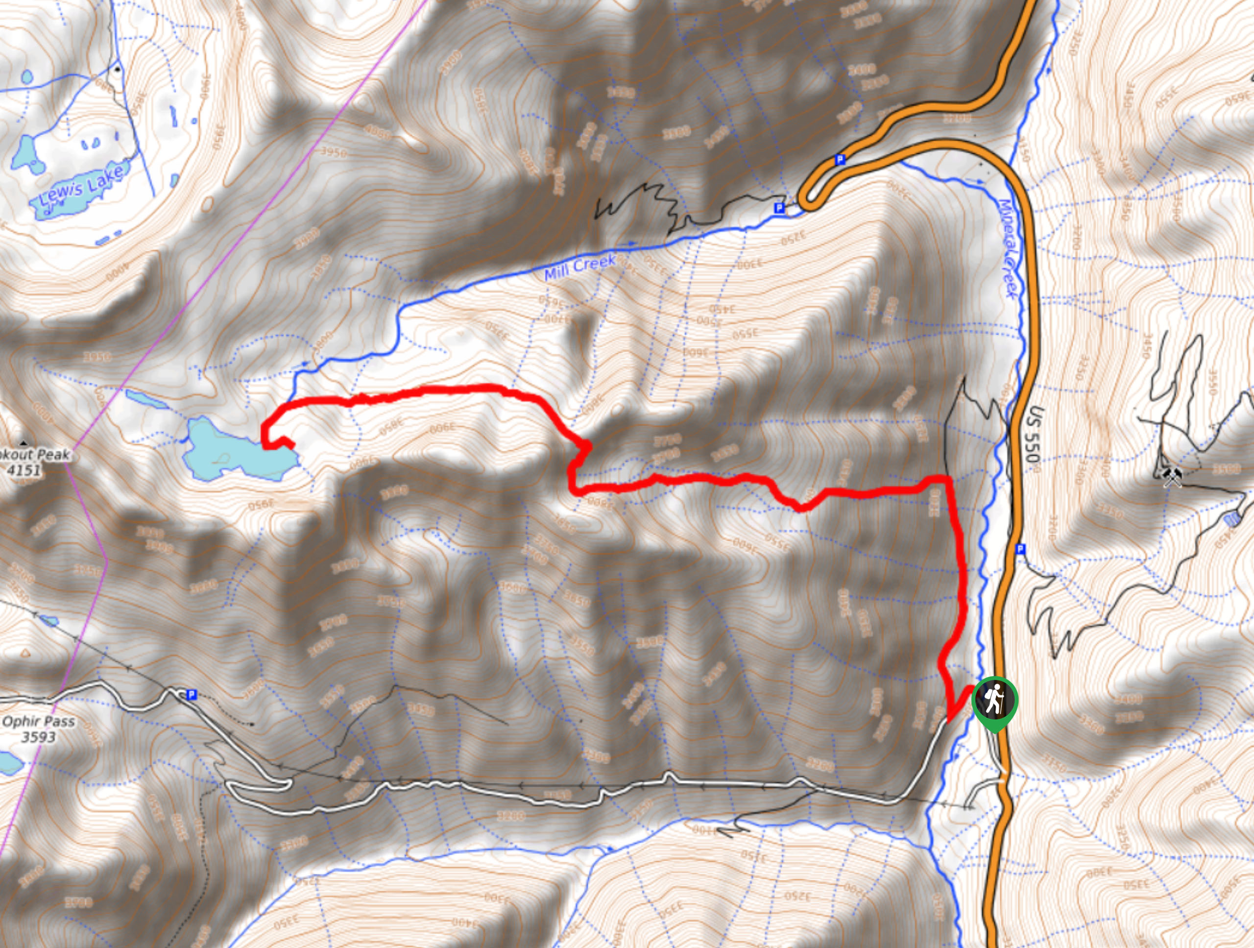
Columbine Lake Trail #509 is a fantastic hiking route in the San Juan Mountains that will take you up to a breathtaking alpine lake with some of the best views in Colorado. While out on the trail you will work your way up a steep slope that features 16 switchbacks, before being greeted by an amazing alpine scene of rugged mountain peaks and strikingly blue water. Hikers should take note that, while camping is permitted at the lake, the alpine meadow ecosystem there is fragile, so take extra care and leave the area exactly as you found it.
Getting there
The trailhead for Columbine Lake Trail #509 can be found along Ophir Pass Road, just 0.2mi northwest of the junction with US-550.

About
| Backcountry Campground | Columbine Lake |
| When to do | Year-Round |
| Pets allowed | Yes |
| Family friendly | No |
| Route Signage | Average |
| Crowd Levels | Moderate |
| Route Type | Out and back |
Columbine Lake Trail #509
Elevation Graph
Weather
Columbine Lake Trail #509 Description
Featuring plenty of switchbacks along the trail and a good amount of elevation gain, the Columbine Lake Trail #509 is a challenging route that will definitely give you a bit of a leg burn. Be sure to bring plenty of water and snacks to stay fuelled on your hike. Additionally, proper hiking boots with great ankle support will be key in staying comfortable on this steep route.
Although it is a challenge to get there, once you arrive at the turquoise shores of Columbine Lake you will be inundated with absolutely breathtaking views of the surrounding alpine landscape. This hike is the definition of getting rewarded for your effort, so make sure to leave the area around the lake just as you found it so that others can also enjoy its pristine beauty.
Setting out from the trailhead, you will follow Ophir Pass Road for roughly 0.2mi and turn right along the forest service road. Here, you will follow the road through a mixture of spruce and fir trees for 0.8mi, where you will find a path branching off to the left that is well-marked.
Turn left onto the trail and follow it as it begins to climb sharply up the mountainside. Terrain here will be very steep and you will need to traverse a series of 16 switchbacks in order to work your way uphill and out of the forest.
Continuing uphill through a wonderfully scenic alpine basin, you will follow the trail for 1.4mi as it traverses a saddle before arriving at a fork in the path. Keep right here and follow the trail west until it meets up with the banks of Mill Creek, at which point you will head south towards the shoreline of Columbine Lake.
Take some time here to explore the area, while taking in views of the strikingly blue water of the lake and the surrounding mountain terrain. Once you have spent enough time in this beautiful location, head back along the same trail and work your way back through the switchbacks to return to the trailhead where you began the Columbine Lake Trail #509.
Trail Highlights
Columbine Lake
Located high above Ophir Pass to the northwest of Silverton, Columbine Lake is a stunning turquoise body of water that sits at an elevation of 12684ft. The glacial lake is drained by Mil;l Creek, which flows down the mountainside into Ophir Pass. Overlooking the Columbine Lake is the rugged summit of Lookout Peak at 13619ft.
Frequently Asked Questions
Where is Columbine Lake located?
Columbine Lake can be found near Ophir Pass, just northwest of Silverton, Colorado.
What elevation is Columbine Lake?
Columbine Lake is situated in the Rocky Mountains at an elevation of 12685ft.
Insider Hints
Wear proper hiking boots with good support.
Bring plenty of water, as the trail is steep and tiring.
Similar hikes to the Columbine Lake Trail #509 hike

Twin Buttes and Lightner Creek Loop Trail
The Twin Buttes and Lightner Creek Loop Trail is a great hiking route in Durango, Colorado that features some challenging…

Meadow Loop via Horse Gulch Trail
The Meadow Loop via Horse Gulch Trail is a great hiking route in Durango that will take you uphill for…

The Ridge Trail
The Ridge Trail - also known as Raiders Ridge Trail - is an amazing hiking route in Durango, Colorado that…
Comments