
Plunge Creek Truck Trail
View Photos
Plunge Creek Truck Trail
Difficulty Rating:
Hiking the Plunge Creek Truck Trail is a pleasant excursion into the San Bernardino Mountains that will offer some scenic views of the Southern California landscape. While out on the trail, you will steadily climb uphill along a dirt track, gaining a decent amount of elevation that will be sure to tire you out a bit. Make sure to wear sunscreen and/or protective clothing, as this route doesn’t feature much shade to block out the sun.
Getting there
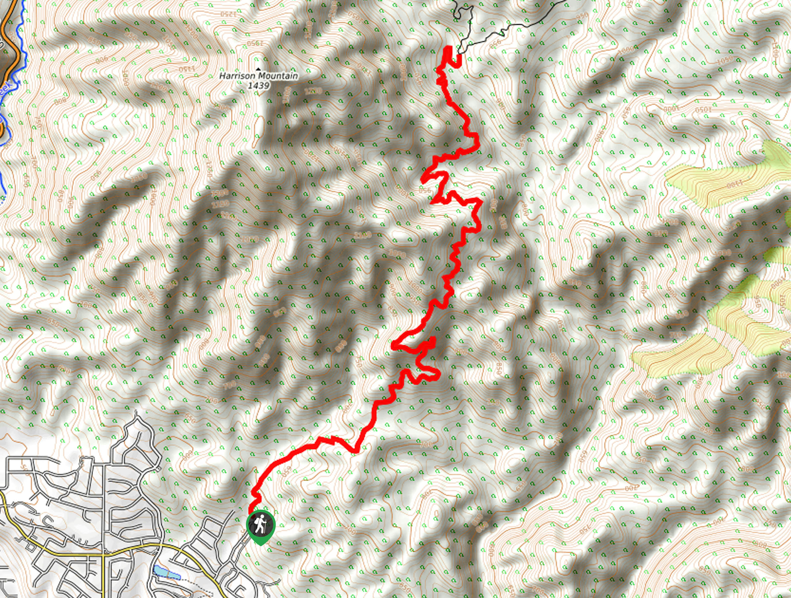
The starting point for the Plunge Creek Truck Trail can be found at the end of Van Leuven Lane in Highland, California.

About
| Backcountry Campground | No |
| When to do | Year-Round |
| Pets allowed | Yes - On Leash |
| Family friendly | Older Children only |
| Route Signage | Average |
| Crowd Levels | Moderate |
| Route Type | Out and back |
Plunge Creek Truck Trail
Elevation Graph
Weather
Plunge Creek Truck Trail Description
While the Plunge Creek Truck Trail follows along a dirt road without much variation in terms of terrain, that doesn’t mean that it is lacking in views. If you are after a scenic adventure near Highland, then this is a great option to explore, just be sure to display your adventure pass when parking your vehicle.
Setting out from the starting point at the end of Van Leuven Lane, you will make your way north along the track and follow it as it winds uphill. Be sure to take your time here, as the steady elevation gain will certainly catch up with you if you try to speedily make your way uphill.
The trail will quickly bend to the northeast and take you along the lower slopes of Harrison Mountain. Here, you will gain elevation through the hill landscape and be able to take in the scenic views that stretch out across the landscape, before arriving at the end point of the route. After pausing for a break, simply utilize the same route to return to the trailhead.
Similar hikes to the Plunge Creek Truck Trail hike

Bluff Mesa Hike
The Bluff Mesa Hike is a fantastic adventure in Southern California that features a lovely woodland setting and can be…

Palm View Peak Trail
The Palm View Peak Trail is a great hiking route in the San Bernardino National Forest that features a solid…

Cram Peak Ridge Trail
The Cram Peak Ridge Trail is a fantastic, albeit difficult, hiking route in the San Bernardino National Forest that will…
Comments