
Marshall Peak Trail
View Photos
Marshall Peak Trail
Difficulty Rating:
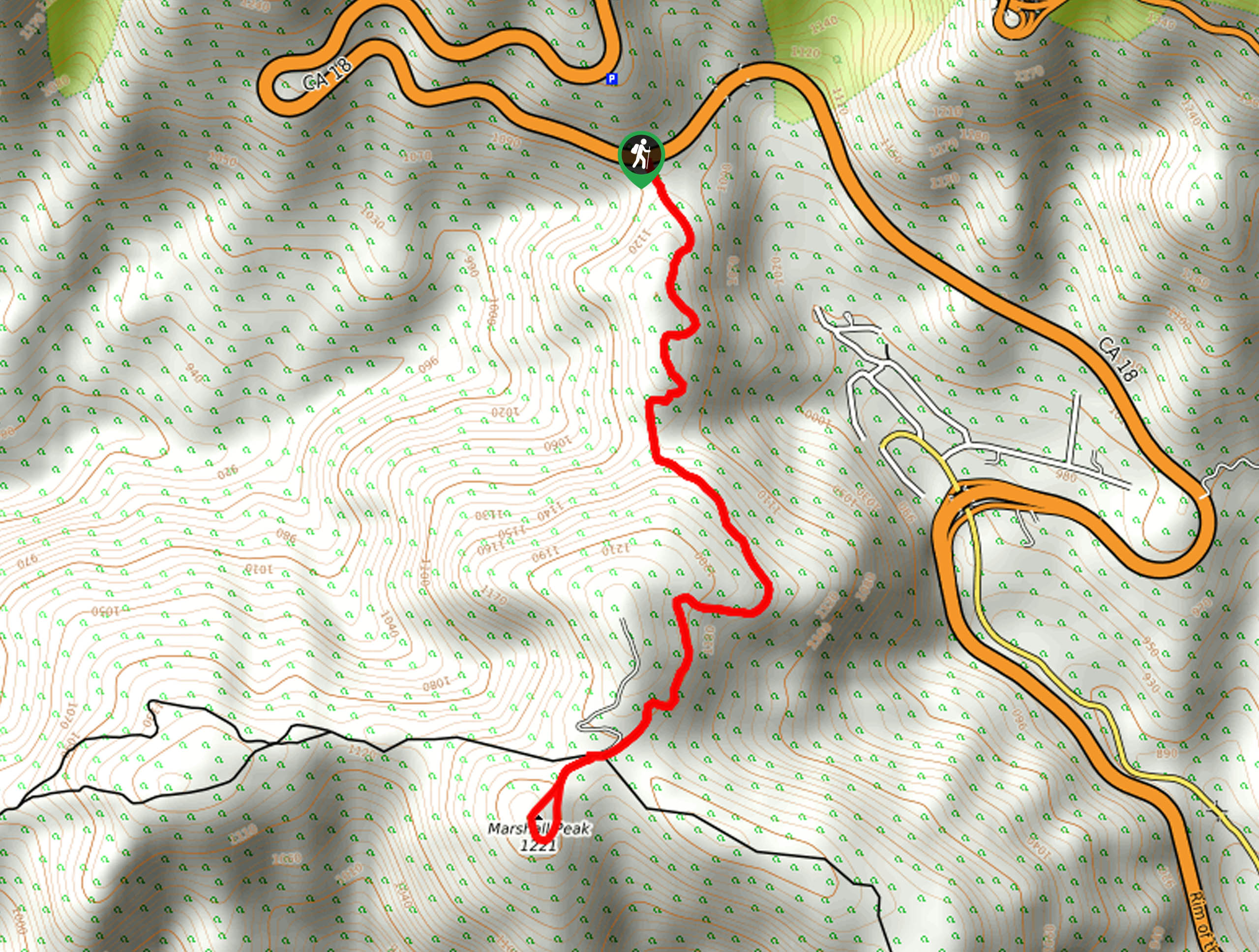
The Marshall Peak Trail is a fairly short hiking route near San Bernardino that offers some beautiful views overlooking the city. While out hiking the trail, you will climb uphill along a forest service road to reach the summit of Marshall Peak, where you will have sweeping views of the Southern California landscape from a paragliding launch. Hikers should take note that there is a fair amount of trash and debris along the initial portion of the hike, but do not worry, as this is short lived and there are beautiful views beyond.
Getting there
The starting point for the Marshall Peak Trail can be found along CA-18, just 7.2mi north of Wildwood Dog Park in San Bernardino.

About
| Backcountry Campground | No |
| When to do | March-November |
| Pets allowed | Yes - On Leash |
| Family friendly | Yes |
| Route Signage | Average |
| Crowd Levels | Moderate |
| Route Type | Out and back |
Marshall Peak Trail
Elevation Graph
Weather
Marshall Peak Trail Description
If you are after a quick adventure near San Bernardino, California that features an easy to navigate dirt road and sweeping views of the city from a summit, then the Marshall Peak Trail is an ideal route to explore.
Setting out from the trailhead, you will follow along the road as it climbs uphill to the south and cuts through some woodland terrain. Although some less than considerate people decided to dump a bunch of trash near the initial stretch of this trail, it is short lived the further away you get from the highway.
As you continue steadily climbing uphill, you will gain a better perspective of the surrounding landscape, before finally arriving at the summit of Marshall Peak. Here, you can relax and gaze out across San Bernardino, while hopefully catching sight of some adventurous paragliders taking off from the launch point. After taking in the views, simply head back along the same route to return to the trailhead.
Similar hikes to the Marshall Peak Trail hike

Bluff Mesa Hike
The Bluff Mesa Hike is a fantastic adventure in Southern California that features a lovely woodland setting and can be…

Palm View Peak Trail
The Palm View Peak Trail is a great hiking route in the San Bernardino National Forest that features a solid…

Cram Peak Ridge Trail
The Cram Peak Ridge Trail is a fantastic, albeit difficult, hiking route in the San Bernardino National Forest that will…
Comments