Hanna Flat to Grays Peak Hike
View Photos
Hanna Flat to Grays Peak Hike
Difficulty Rating:
The Hanna Flat to Grays Peak Hike is a great route west of Fawnskin in the San Bernardino National Forest that will take you to a summit vantage point for views of the surrounding area. While out hiking the trail, you will traverse a stretch of undulating terrain with light tree cover, before making the climb up to the summit of Grays Peak for scenic views. Be sure to bring plenty of sunscreen, as large portions of this trail are exposed to the sun.
Getting there
The starting point for the Hanna Flat to Grays Peak Hike can be found at the Hanna Flat Campground along Coxey Road.

About
| Backcountry Campground | Yellow Post #2, Gray’s Peak Group Campground |
| When to do | May-September |
| Pets allowed | Yes |
| Family friendly | No |
| Route Signage | Average |
| Crowd Levels | Low |
| Route Type | Out and back |
Hanna Flat to Grays Peak Hike
Elevation Graph
Weather
Hanna Flat to Grays Peak Hike Description
If you are after a long, but fairly laidback adventure in the San Bernardino National Forest that will lead you up to the top of a summit with sweeping views, then you should certainly check out the Hanna Flat to Grays Peak Hike.
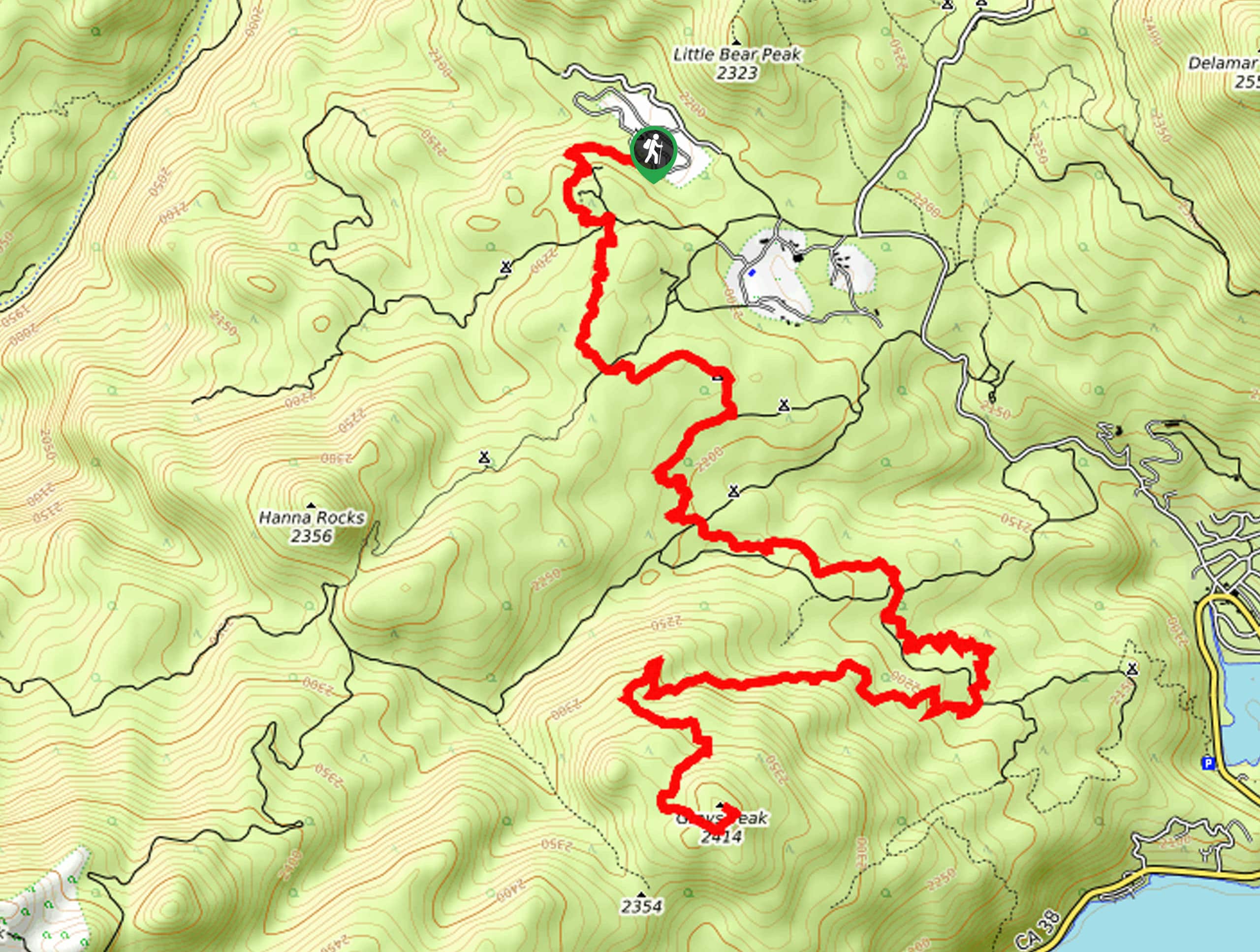
Setting out from the trailhead at Hanna Flat Campground, you will head to the south through the forest, where you will pass by the rock strewn terrain of the Hanna Flat Big Bear Lake Lookout. From here, the trail continues south past the Yellow Post #2 and Grays Peak campgrounds, bending to the southeast before turning back to the west to begin the ascent of Grays Peak.
Here, you will climb uphill across the northern face of the mountain, eventually turning to the south for the final push up to the summit through some rocky terrain. Tackle some time here to appreciate the beautiful views of the surrounding area, before heading back down along the same route for the return into the campground where you started.
Similar hikes to the Hanna Flat to Grays Peak Hike hike

Bluff Mesa Hike
The Bluff Mesa Hike is a fantastic adventure in Southern California that features a lovely woodland setting and can be…

Palm View Peak Trail
The Palm View Peak Trail is a great hiking route in the San Bernardino National Forest that features a solid…

Cram Peak Ridge Trail
The Cram Peak Ridge Trail is a fantastic, albeit difficult, hiking route in the San Bernardino National Forest that will…
Comments