
Hanna Flat Campground Trail
View Photos
Hanna Flat Campground Trail
Difficulty Rating:
The Hanna Flat Campground Trail is a fun hiking excursion in San Bernardino National Forest that will see you traverse some undulating terrain while enjoying scenic views of the surrounding landscape. While out hiking the trail, you will climb uphill through the forest along the lower slopes of Gray’s Peak and take in views of Big Bear Lake, before continuing across the rugged landscape on the way to the Hanna Flat Campground. This is a great hiking route if you are also looking to enjoy a fun weekend of camping in the San Bernardino Mountains.
Getting there
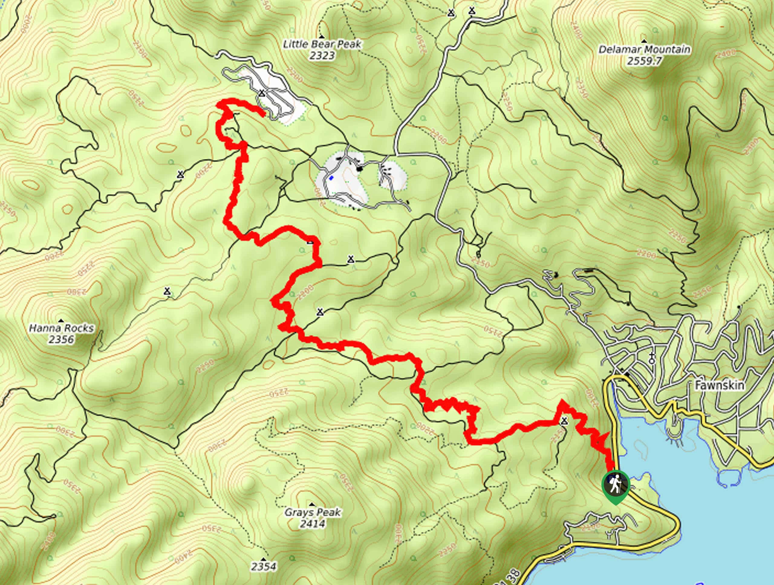
The starting point for the Hanna Flat Campground Trail can be found at the Gray’s Peak Trailhead on CA-38, just southwest of Fawnskin.

About
| Backcountry Campground | Gray’s Peak, Yellow Post #1, Yellow Post #2, Hanna Flat |
| When to do | May-October |
| Pets allowed | No |
| Family friendly | Older Children only |
| Route Signage | Average |
| Crowd Levels | Low |
| Route Type | Out and back |
Hanna Flat Campground Trail
Elevation Graph
Weather
Hanna Flat Campground Trail Description
Although there isn’t an overly large amount of elevation gain along the Hanna Flat Campground Trail, it is still a challenging hike that features some rugged terrain. Be sure to wear proper hiking boots with good support in order to have the best footing along the trail. Additionally, access to this trail does require an adventure pass, so be sure to purchase one prior to setting out on your hike or else you will be fined.
Whether you are planning for a fun weekend of camping or are simply looking for a solid day hike, the Hanna Flat Campground Trail will be sure to provide you with hours of fun. A pleasant forest setting, undulating mountain terrain, and scenic views overlooking Big Bear Lake await on this great outdoor adventure in San Bernardino National Forest.
Setting out from the Gray’s Peak Trailhead on CA-38, follow the trail as it leads uphill through the forest to the northwest for 0.7mi, passing by the Yellow Post #1 campsite to arrive at a junction with Forest Road 2N70. Here, you will turn right and keep right for the next 0.5mi, where you will find a path branching off into the forest on your right.
Taking this path, you will traverse a rocky stretch of woodland terrain for 0.7mi and meet back up with the road, following it to the right. Here, you will quickly arrive at a junction and take the path on the left, where you will immediately be met with a fork. Keep right here and continue along the trail as it bends to the northwest through the dense cover of the forest.
After 0.7mi, you will cross directly over the road and pick up the trail on the opposite side, keeping left for another 1.1mi to pass by the Yellow Post #2 campsite and meet up with a road. Once again crossing over to the opposite side, you will traverse the rocky landscape to the north for another 0.5mi. Here, you will cross over yet another road and pick up the trail that will take you past the Hanna Flat Big Bear Lake Lookout.
After a quick climb up the rocks to take in the views stretching south to Big Bear Lake, you will follow the trail as it descends slightly to the northeast to arrive at the endpoint of the route at the Hanna Flat Campground. If you are planning on camping overnight you can begin to set up camp, otherwise, simply head back along the same route to return to the starting point of the Hanna Flat Campground Trail.
Trail Highlights
Big Bear Lake
Big Bear Lake is the largest recreational lake in Southern California and can be found in the San Bernardino Mountains. The 2,971 acre body of water has no tributaries, streams, or rivers that feed into it to restore its water levels each year. Instead, Big Bear Lake is replenished by snowmelt from the surrounding mountains.
Insider Hints
You will need to display an adventure Pass in order to access this route.
A good amount of this trail is exposed to the sun, so make sure to bring sunscreen/protective clothing and plenty of water.
Proper hiking boots will be needed to safely traverse the rugged terrain.
Pair this hike with a fun weekend of camping at a nearby site.
Similar hikes to the Hanna Flat Campground Trail hike

Bluff Mesa Hike
The Bluff Mesa Hike is a fantastic adventure in Southern California that features a lovely woodland setting and can be…

Palm View Peak Trail
The Palm View Peak Trail is a great hiking route in the San Bernardino National Forest that features a solid…

Cram Peak Ridge Trail
The Cram Peak Ridge Trail is a fantastic, albeit difficult, hiking route in the San Bernardino National Forest that will…
Comments