Grays Peak Trail
View Photos
Grays Peak Trail
Difficulty Rating:
The Grays Peak Trail is an amazing intermediate length hiking route in San Bernardino National Forest that will take you up to a gorgeous summit viewpoint. While out on the trail, you will work your way uphill through a wonderfully atmospheric stretch of woodland terrain, before arriving at the top of Grays Peak for views of Big Bear Lake. Hikers should take note that this trail is sometimes closed due to habitat protection, so make sure to check its status in advance of your hike.
Getting there
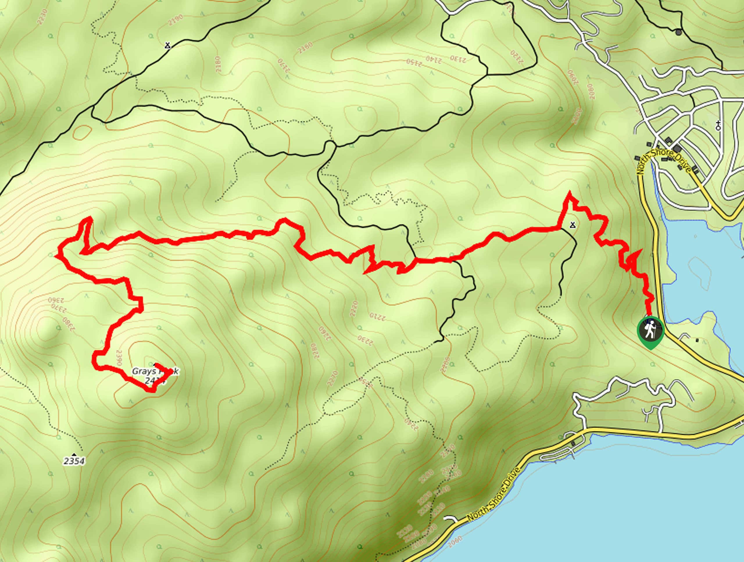
The Grays Peak Trailhead can be found along North Shore Drive/CA-38, just 0.5mi south of Fawnskin.

About
| Backcountry Campground | Yellow Post #1 |
| When to do | May-September |
| Pets allowed | Yes - On Leash |
| Family friendly | Older Children only |
| Route Signage | Average |
| Crowd Levels | High |
| Route Type | Out and back |
Grays Peak Trail
Elevation Graph
Weather
Grays Peak Trail Description
For those outdoor enthusiasts in the San Bernardino area that are after a beautifully scenic hiking route that isn’t over technical or challenging, the Grays Peak Trail is a fun hike that offers just enough difficulty and some truly rewarding views overlooking the expanse of Big Bear Lake.
Setting out from the trailhead, you will make your way to the north through the cover of the forest, following the trail as it climbs uphill past the Yellow Post #1 Campsite. From here, the route will bend to the west and continue uphill through the forest, although the tree cover will lighten somewhat.
After traversing the north face of Grays Peak, the trail will turn to the south and continue pushing further uphill through some rocky terrain on the way to the summit. Once there, you will be met with gorgeous views overlooking Big Bear Lake and the surrounding mountains. After pausing for a quick rest, you can head back down the mountainside along the same route to return to the trailhead where you began your journey up Grays Peak.
Similar hikes to the Grays Peak Trail hike

Bluff Mesa Hike
The Bluff Mesa Hike is a fantastic adventure in Southern California that features a lovely woodland setting and can be…

Palm View Peak Trail
The Palm View Peak Trail is a great hiking route in the San Bernardino National Forest that features a solid…

Cram Peak Ridge Trail
The Cram Peak Ridge Trail is a fantastic, albeit difficult, hiking route in the San Bernardino National Forest that will…
Comments