Ernie Maxwell Trail
View Photos
Ernie Maxwell Trail
Difficulty Rating:
The Ernie Maxwell Trail is a spectacular nature hike in Southern California that features a variety of terrain and wonderfully scenic views. While out hiking the trail, you will gain a small amount of elevation as you work through the forest and take in the awesome views of surrounding mountain peaks. Sections of this route are a bit narrow and rocky, but it is still a great trail that the entire family can enjoy.
Getting there
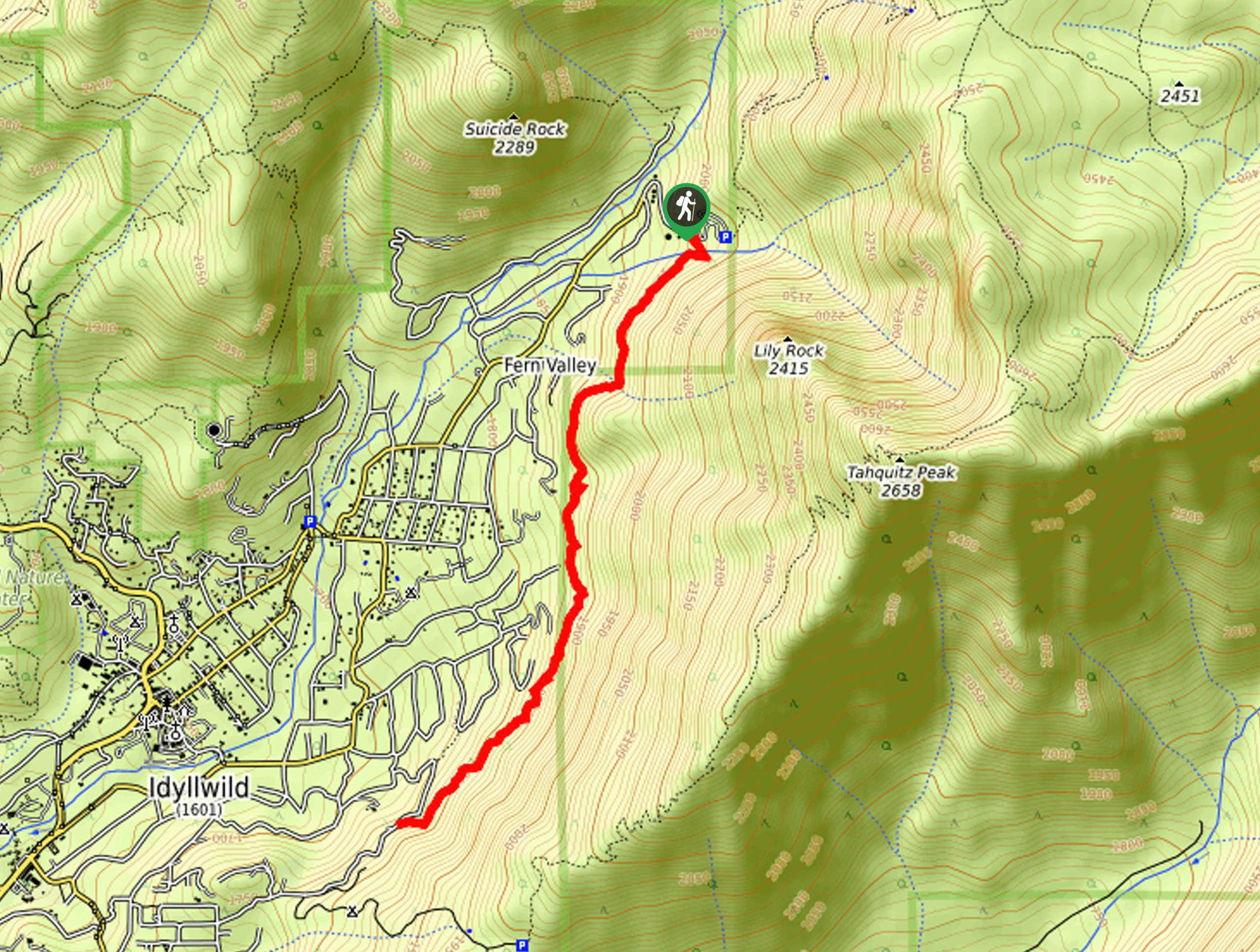
The starting point for the Ernie Maxwell Trail can be found along Fern Valley Road, just 2.5mi northeast of Idyllwild.

About
| Backcountry Campground | No |
| When to do | May-October |
| Pets allowed | Yes - On Leash |
| Family friendly | Yes |
| Route Signage | Average |
| Crowd Levels | High |
| Route Type | Out and back |
Ernie Maxwell Trail
Elevation Graph
Weather
Ernie Maxwell Trail Description
Even though it isn’t an overly long or challenging route, you will still need to arrive prepared for the Ernie Maxwell Trail. Rough terrain in certain sections of the trail can be difficult for some to traverse, so wear proper hiking footwear for the best traction along the trail. Additionally, if you are planning on hiking this trail in the winter, hiking poles and microspikes are recommended to better traverse the icy ground. Be sure to obtain a free permit prior to setting out on your adventure.
Although there isn’t really a main viewpoint or vista, the Ernie Maxwell Trail is a beautifully scenic hiking route that will be sure not to disappoint. The route features a peaceful woodland setting and beautiful views of the surrounding mountains throughout, making for a fun adventure in Southern California.
Setting out from the trailhead, you will follow the path south and into the cover of the forest, where you will cross over the banks of Fern Valley Creek in just 340ft. From here, the trail will continue on to the southwest for another 0.5mi, offering intermittent views of nearby peaks before arriving at another creek crossing.
Take some time here to appreciate the tranquility of the woodland atmosphere, enjoying the views as you hike along the hillside above Fern Valley for the next 1.7mi. Here, you will descend slightly to arrive at the endpoint of the trail at the edge of Tahquitz View Drive. Turning back along the trail, you will retrace your steps and relive the beautiful views on the way back to the point where you began the Ernie Maxwell Trail.
Insider Hints
Make sure to obtain a permit prior to your adventure.
Wear Proper hiking footwear.
Arrive early for parking.
Hiking poles and microspikes are recommended in cold/icy weather.
Similar hikes to the Ernie Maxwell Trail hike

Bluff Mesa Hike
The Bluff Mesa Hike is a fantastic adventure in Southern California that features a lovely woodland setting and can be…

Palm View Peak Trail
The Palm View Peak Trail is a great hiking route in the San Bernardino National Forest that features a solid…

Cram Peak Ridge Trail
The Cram Peak Ridge Trail is a fantastic, albeit difficult, hiking route in the San Bernardino National Forest that will…
Comments