Castle Rock Trail
View Photos
Castle Rock Trail
Difficulty Rating:
The Castle Rock Trail is one of the more popular hiking routes within San Bernardino National Forest, and it is for good reason. While out on the trail, you will climb up a steep and often rocky path to reach a breathtaking vantage point at the summit of Castle Rock, where you will take in views overlooking Big Bear Lake. Hikers should take note that parking is limited at the trailhead and fills up quickly, so make sure to arrive early to secure a space.
Getting there
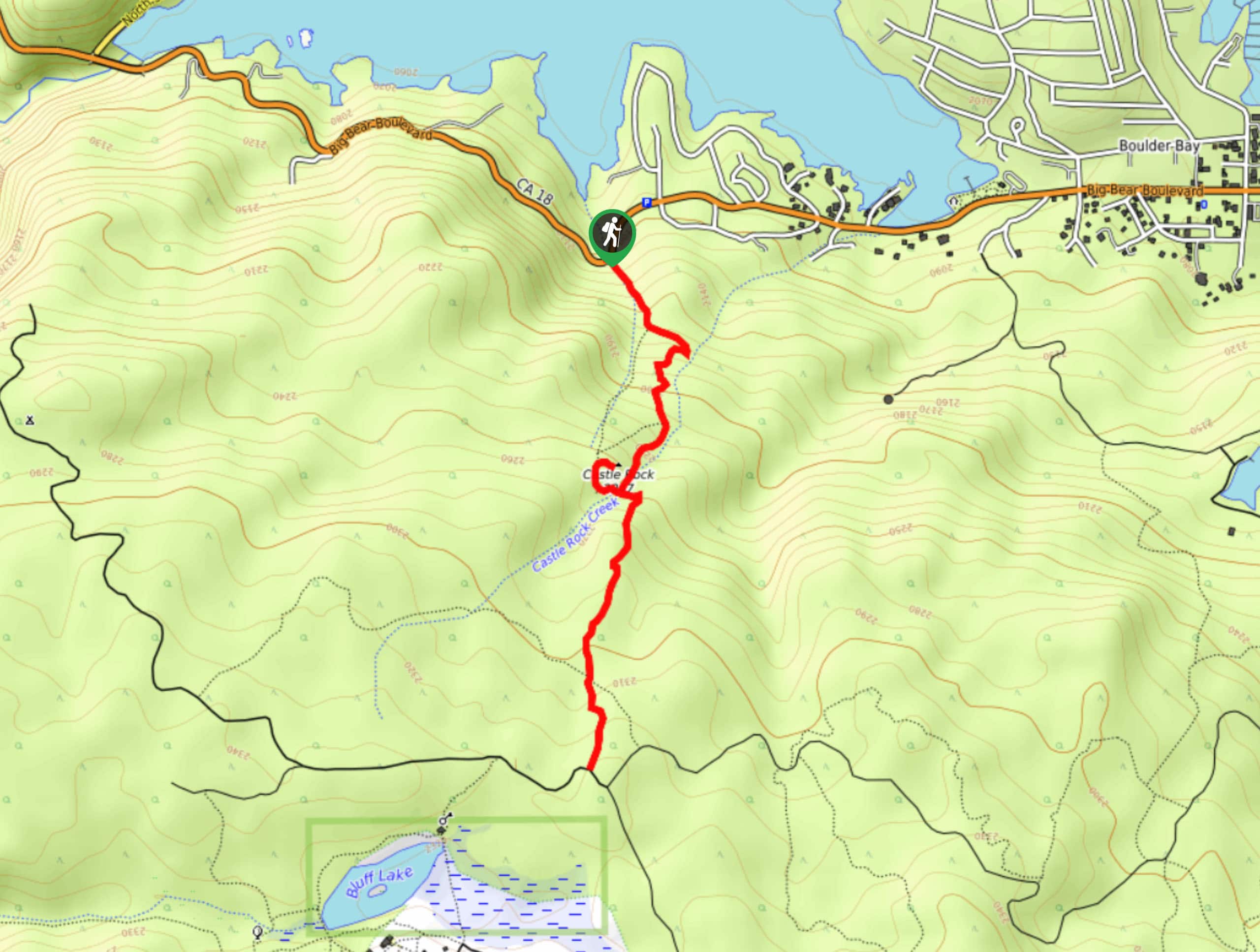
The starting point for the Castle Rock Trail can be found along CA-18, just 1.2mi southeast of the Bear Valley Dam.

About
| Backcountry Campground | No |
| When to do | April-October |
| Pets allowed | Yes - On Leash |
| Family friendly | Older Children only |
| Route Signage | Average |
| Crowd Levels | High |
| Route Type | Out and back |
Castle Rock Trail
Elevation Graph
Weather
Castle Rock Trail Description
Featuring some steep and rocky terrain within a beautiful woodland setting, the Castle Rock Trail is still a challenging hike that will require a good level of fitness. Be sure to wear proper hiking shoes and bring hiking poles to save your knees on the descent. Additionally, the beautiful views along the trail make it a popular one, so try to arrive early to secure a parking space and make sure to have your adventure pads visible in your vehicle.
Although it is quite popular, the Castle Rock Trail is one of the best hiking routes in the Big Bear Lake area. Climbing up the steep trail through the woodland landscape, you will gain an incredible view overlooking the San Bernardino Mountains and the lake below. It is a bit of a challenge to reach the summit, but the views are well worth the effort.
Setting out from the trailhead, you will enter into the dense cover of the forest and follow along the trail as it runs to the southeast alongside Castle Rock Creek. Here, you will immediately begin to climb up the steep hillside and keep to the left as you gain elevation through the forest landscape.
After 0.6mi of uphill hiking along the trail, you will cross over Castle Rock Creek and arrive at a junction, taking the path on the right in order to climb up to the summit of Castle Rock Peak itself. Crossing once again over Castle Rock Creek, you will keep to the right and do some light scrambling over the rocky terrain in order to reach the summit. Here, you will experience sweeping views across the California landscape, including Big Bear lake to the north below.
Once you have taken in the views, head back along the same path for 0.1mi to arrive back at the junction in the trail. Keep right here and continue along the trail as it turns south through the woodland landscape for another 0.4mi to arrive at a junction. Passing straight through, you will follow the trail for another 0.2mi to arrive at the endpoint of the route at the edge of a forest service road.
From here, you will turn back along the trail to retrace your footsteps and relish in the woodland scenery on the return leg of the hike. After passing by Castle Rock, carefully descend the steep hillside on the way into the trailhead where you began your adventure on the Castle Rock Trail.
Trail Highlights
Big Bear Lake
Situated in the San Bernardino Mountains, Big Bear Lake is Southern California’s largest recreational lake, with a surface area of 2971 acres. The lake has no tributaries feeding into it, making its replenishment completely reliant on melting snow from the surrounding mountains.
Frequently Asked Questions
How tall is Castle Rock?
The summit of Castle Rock is located in the San Bernardino Mountains at an elevation of 7372ft.
Do I need an Adventure Pass for the Castle Rock Hike?
Yes, an Adventure Pass is required to complete the Castle Rock Trail.
Insider Hints
Wear proper hiking boots with good ankle support.
Arrive early, as parking at the trailhead is quite limited.
Make sure to keep your dog under control or on a leash.
Similar hikes to the Castle Rock Trail hike

Bluff Mesa Hike
The Bluff Mesa Hike is a fantastic adventure in Southern California that features a lovely woodland setting and can be…

Palm View Peak Trail
The Palm View Peak Trail is a great hiking route in the San Bernardino National Forest that features a solid…

Cram Peak Ridge Trail
The Cram Peak Ridge Trail is a fantastic, albeit difficult, hiking route in the San Bernardino National Forest that will…
Comments