
Castle Rock Peak Hike
View Photos
Castle Rock Peak Hike
Difficulty Rating:
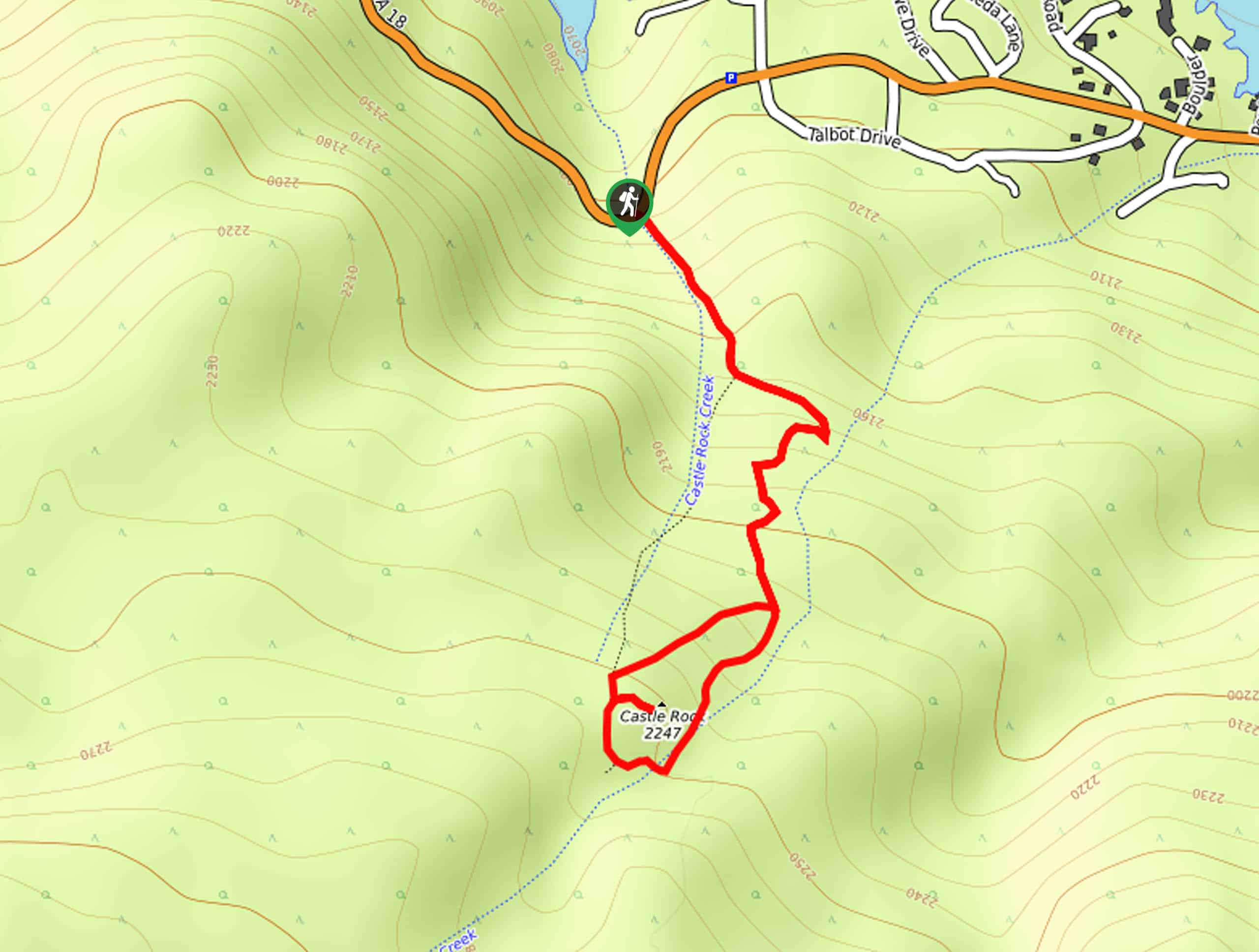
The Castle Rock Peak Hike is a short, but beautifully, scenic adventure in the San Bernardino National Forest that will take you on a steep climb up to a stunning viewpoint. While out hiking the trail, you will work your way uphill through the forest alongside Castle Rock Creek, before pushing on to the rocky summit for gorgeous views overlooking Big Bear Lake. The best views can be had after a short scramble up some rocks, but they are well worth the minimal effort.
Getting there
The trailhead for the Castle Rock Peak Hike can be found just 1.2mi southeast of the Bear Valley Dam on CA-18.

About
| Backcountry Campground | No |
| When to do | March-October |
| Pets allowed | Yes - On Leash |
| Family friendly | Yes |
| Route Signage | Average |
| Crowd Levels | High |
| Route Type | Lollipop |
Castle Rock Peak Hike
Elevation Graph
Weather
Castle Rock Peak Hike Description
Although it is only a short route, the Castle Rock Peak Hike is quite steep and will require a bit of physical fitness to traverse. Make sure to wear proper hiking boots and bring poles for stability. Additionally, you should try to arrive early in order to secure parking near the trailhead.
If you are looking for a quick and rewarding hike in the San Bernardino area, then look no further than the Castle Rock Peak Hike. This short trail will lead you up a steep forested path to a rocky summit with spectacular views overlooking Big Bear Lake. The best views will require a bit of clambering over the rocky terrain to reach, but there aren’t many better vantage points in the surrounding area.
Setting out from the Castle Rock Trailhead on Big Bear Boulevard, you will follow the trail as it enters into the cover of the forest to the southeast. Here, you will immediately begin to climb up the steep hillside along the banks of Castle Rock Creek, working your way through the atmospheric woodland landscape to reach a junction after 0.2mi.
Taking the path on the left, the trail will become even more steep as you continue climbing up the mountainside to the south. Stretches of the trail here will be quite rocky as well, so keep an eye on your footing and carefully work your way through the uneven ground.
After 0.3mi of hiking from the previous junction, you will arrive at another and follow it once again to the left alongside Castle Rock Creek for another 0.2mi to approach a T-intersection in the trail. Turning to the right, you will cross over the creek and make your way west, very quickly climbing further uphill to arrive at the summit of Castle Rock.
Take some time here to explore the area, climbing on top of the rocks in order to get the best views looking out over Big Bear Lake and the surrounding mountains. Once you have had your fill of the views, you can head down from the summit in a northeast direction, where you will quickly meet up with your original path. Following this to the left, you will head back down the mountainside on the return into the trailhead where you began the Castle Rock Peak Hike.
Trail Highlights
Big Bear Lake
Located in the San Bernardino Mountains of California, Big Bear Lake is the largest recreational lake in Southern California, with a total surface area of 2971 acres. There are no tributaries feeding into the lake, instead, its water levels are replenished by snowmelt from the surrounding mountains.
Frequently Asked Questions
What elevation is Castle Rock?
The Castle Rock is a summit in the San Bernardino Mountains of California that is situated at an elevation of 7372ft.
Will I need an Adventure Pass to do the Castle Rock Hike?
Yes, a valid Adventure Pass is required to hike the Castle Rock Trail.
Insider Hints
Wear proper hiking boots for this hike.
You will need to purchase an Adventure Pass and display it on your dashboard.
Arrive early, as parking at the trailhead can become limited.
Be sure to keep your dog on a leash.
Similar hikes to the Castle Rock Peak Hike hike

Bluff Mesa Hike
The Bluff Mesa Hike is a fantastic adventure in Southern California that features a lovely woodland setting and can be…

Palm View Peak Trail
The Palm View Peak Trail is a great hiking route in the San Bernardino National Forest that features a solid…

Cram Peak Ridge Trail
The Cram Peak Ridge Trail is a fantastic, albeit difficult, hiking route in the San Bernardino National Forest that will…
Comments